Topographic Surveying Explained: Definition, Process, & Why It Matters?

May 29, 2025
If you’ve ever seen someone with a tripod and a strange-looking device at a construction site, chances are you were looking at a topographic survey in action. It may not seem exciting, but it’s one of the most important steps in shaping the spaces we live and work in.
Before any road is built, any building designed, or any land developed, there needs to be a clear understanding of the terrain. That’s exactly what topographic surveying delivers.
While newer technologies, such as drone mapping and LiDAR, often take center stage, topographic surveying remains the foundation. It’s how we turn the natural landscape into accurate, usable data. Without it, engineers can’t plan drainage systems, architects can’t design structures, and construction crews don’t know where to begin.
In this article, we’ll explore what topographic surveying is, how it works, and why it still plays a critical role in land development today.
Let’s delve in.
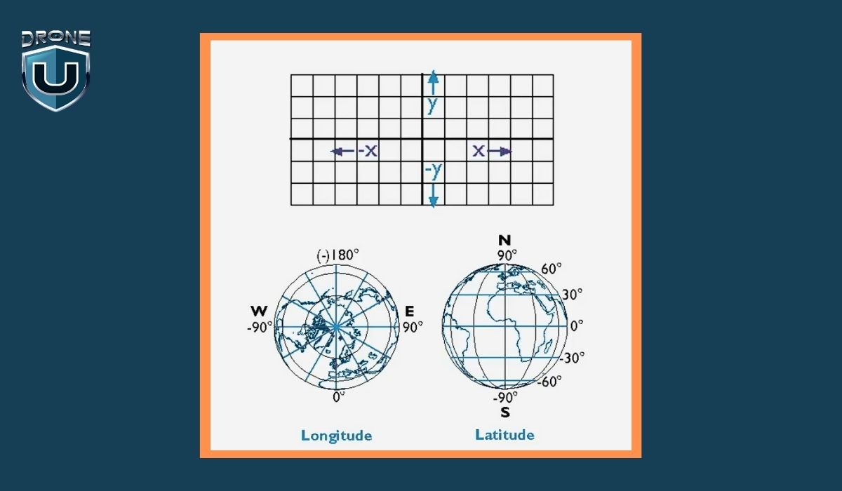
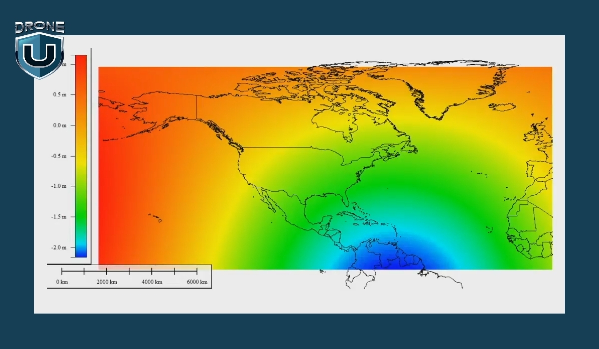
Topographic surveying is the process of measuring and mapping the shape and features of the land. It records both horizontal positions (X and Y) and vertical elevation (Z) of everything on a site, including hills, trees, and rivers, as well as man-made features such as roads, buildings, fences, and drainage ditches.
The result is usually a topographic map. This map shows the surface of the land in detail, using contour lines to represent elevation changes, and symbols or labels to mark important features.
In simple terms, A topographic survey shows you what the land looks like, where everything is, and how the ground rises or falls across the area.
Imagine a company is building a new neighborhood. One of the biggest challenges is managing rainwater so it doesn’t flood the streets or damage houses.
To solve this, engineers need to know exactly how the land slopes — where it’s high and where it’s low. This helps them design a drainage system that guides water safely away from homes.
Additionally, Surveyors measure the land’s elevation and locate important features like ditches, culverts, and roads. This data forms a detailed map showing how water will flow naturally across the site.
Without this survey, engineers might guess the slopes and drainage points. This guesswork can cause water to pool in the wrong places, leading to flooding, costly repairs, and even legal problems.
Example: STRABAG found that using drones for surveys makes the process 80% faster than traditional methods. This big time-saving makes their surveying work for construction projects much more efficient.
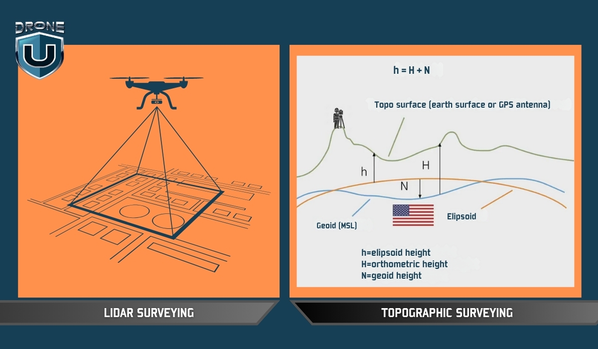
It’s easy to confuse topographic surveying with terms like drone surveying or LiDAR scanning because they often get mentioned together. But they’re not the same, and understanding how they differ is key to knowing which method suits your project best.
| Aspect | Topographic Surveying | LiDAR Surveying |
| What It Is | A survey process focused on mapping elevation and features | A sensor technology that measures distances using lasers |
| Primary Tools | Total stations, GNSS, levels | LiDAR scanners (airborne or terrestrial) |
| Output | Topographic maps with contours, elevations, and site features | Dense point clouds, elevation models |
| Key Difference | Focuses on what is measured | Focuses on what sensor is used to collect elevation |
| Example | Surveyor uses GNSS to map a sloped construction site | LiDAR scanner generates a terrain model beneath the forest cover |
Topographic surveying is about what data you need—the shape and features of the land. LiDAR describes how or with what technology you gather that data.
Modern topographic surveying has been significantly enhanced by drone technology, offering faster, safer, and often more accurate data collection over large or complex terrains.
Here’s how drone-based topographic surveys are conducted and why each stage is important:
The process begins with a thorough reconnaissance phase. Instead of a traditional walkover survey, this stage involves analyzing satellite imagery, reviewing site access, and checking for airspace restrictions or obstacles like power lines, tall trees, or buildings that could interfere with drone flight.
Surveyors also assess weather conditions and light levels, which affect the quality of aerial imagery. Proper planning ensures that the drone mission is efficient, legal, and safe, with minimal risk of data gaps or flight failure.
Although drones capture aerial data, they still rely on precise reference points on the ground to ensure positional accuracy. Surveyors set up Ground Control Points (GCPs)—marked targets with known GPS coordinates—spread strategically across the site. These are recorded using high-precision GNSS equipment.
The drone imagery is later georeferenced to these GCPs, anchoring the aerial data to real-world coordinates and enhancing the survey’s spatial accuracy.
Next, the drone is flown over the site in a pre-programmed flight path, capturing high-resolution aerial images and sometimes LiDAR point cloud data, depending on the equipment used.
Photogrammetry drones use overlapping images to create 3D models and elevation data, while drones equipped with LiDAR sensors can penetrate dense vegetation and provide highly detailed elevation data even in forested or uneven areas. This phase is usually faster than traditional ground surveys and reduces the need for surveyors to navigate difficult terrain directly.
Once the data is collected, it is imported into specialized photogrammetry or GIS software. The software processes the images to generate orthophotos, digital elevation models (DEMs), contour lines, and 3D surface models.
If LiDAR data was collected, it is processed to classify ground points and strip out vegetation or structures as needed. The result is a comprehensive, georeferenced topographic map ready for engineering, planning, or construction use.
Despite the speed of drone surveys, quality control remains essential. Surveyors cross-check the drone-derived outputs with the GCP data to verify accuracy. Any discrepancies are analyzed and corrected through software adjustments or re-flights if needed.
This step ensures that the data meets required tolerances and is suitable for high-stakes applications like design or land development.
Drone-based topographic surveys dramatically reduce the time required compared to traditional methods. A site that might take several days to survey on foot can often be flown and mapped in a few hours.
However, the timeline still depends on factors like site size, terrain complexity, weather conditions, and the extent of data processing required. When optimized, drones can deliver complete, quality-controlled maps within 24–72 hours for many projects.
Topographic surveying isn’t just a technical step—it’s the foundation of every smart, risk-aware decision in construction and land development.
Today, drones have redefined what’s possible, delivering high-resolution data over vast or difficult terrain in a fraction of the time. But the value isn’t in the drone—it’s in the accuracy, insight, and foresight that a well-executed survey provides.
With the rise of drone technology, surveyors can now capture complex terrain data faster and more safely, without compromising accuracy.
But drones don’t replace the need for expert insight—they amplify it.
This reduces risk, prevents costly design errors, and ensures that every structure is built on data that reflects the real world.
