

Class E Airspace: A Comprehensive Guide for Drone Pilots (2026)

May 25, 2026
Quick Answer: Class E AirspaceClass E airspace is FAA-controlled airspace that covers most of the United States between Class G (uncontrolled) airspace below and Class A airspace above 18,000 feet. It is often called “Class Everywhere” because of how widely it appears. When you need authorization: Only in surface Class E (E2) areas. These are found around non-towered airports with IFR procedures. Use LAANC or FAA DroneZone to get approval. When you do not need authorization: Class E starting at 700 feet AGL or 1,200 feet AGL does not require authorization for drone operations below 400 feet. You are flying in Class G below it. Visibility requirement: 3 statute miles below 10,000 feet MSL. Stay 500 feet below clouds, 1,000 feet above clouds, and 2,000 feet horizontally from clouds. Key rule: Remote ID is required in Class E airspace regardless of authorization status. |
Class E airspace is the most common controlled airspace in the United States. It covers the vast majority of the country between ground-level Class G airspace and Class A airspace at 18,000 feet. Drone pilots encounter it more than any other controlled airspace type.
Unlike Class B, C, and D airspace, Class E does not have a single fixed starting altitude. It can begin at the surface, at 700 feet AGL, or at 1,200 feet AGL depending on location. This is the main source of confusion for drone pilots. This guide resolves it.
In this article, we cover where Class E begins, when you need FAA authorization, the five types, visibility requirements, and when and where you can fly.
Class E airspace is one of the six FAA-designated controlled airspace classes in the U.S. It’s often informally referred to as “Class Everywhere” or “Class Eco” due to its widespread presence in the United States.
Class E covers most of the airspace between higher-altitude commercial traffic and lower-level recreational flights. Think of it as the bridge between controlled and uncontrolled airspace.
While Class E may be less restrictive than Class A, B, C, or D airspace, it still maintains specific FAA rules, especially regarding weather minimums, pilot certifications, and ATC services.
Understanding these rules is essential for safe and legal drone operations.
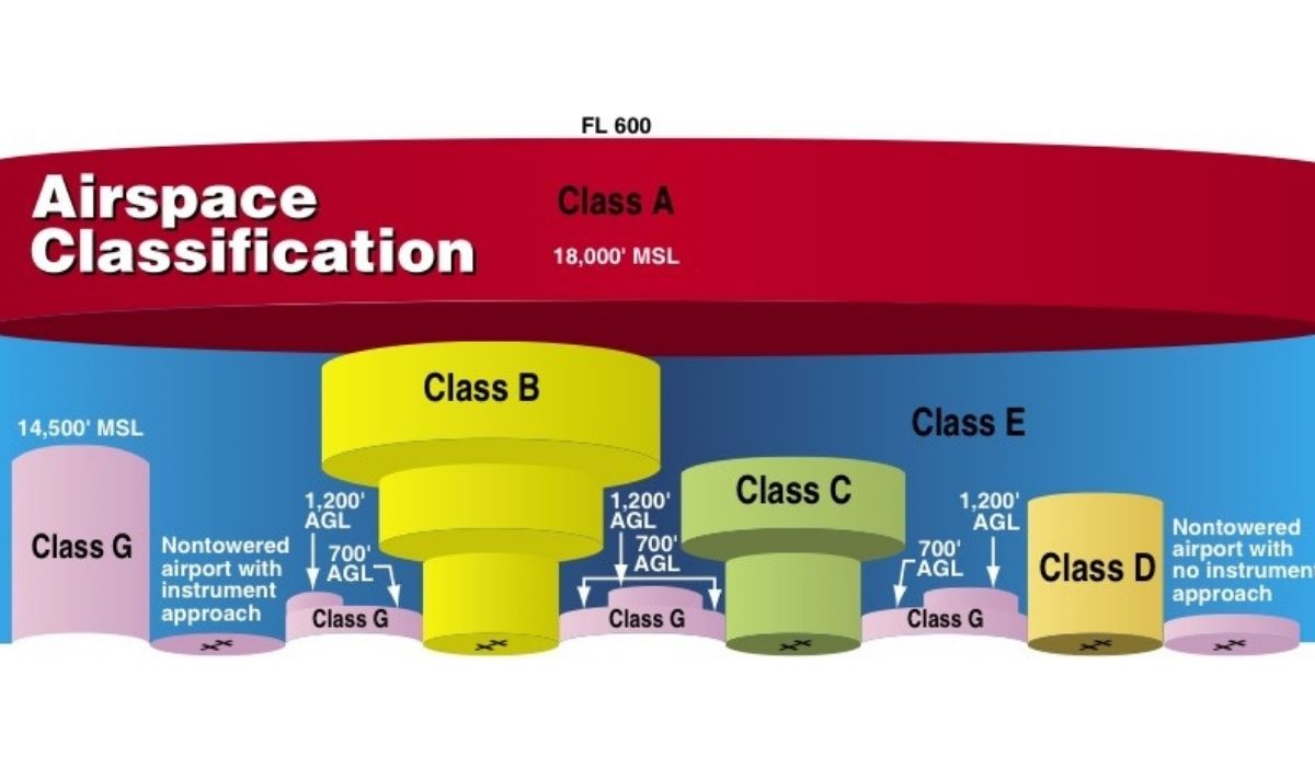
Class E airspace does not have a fixed starting altitude. It begins at different heights depending on location and purpose.
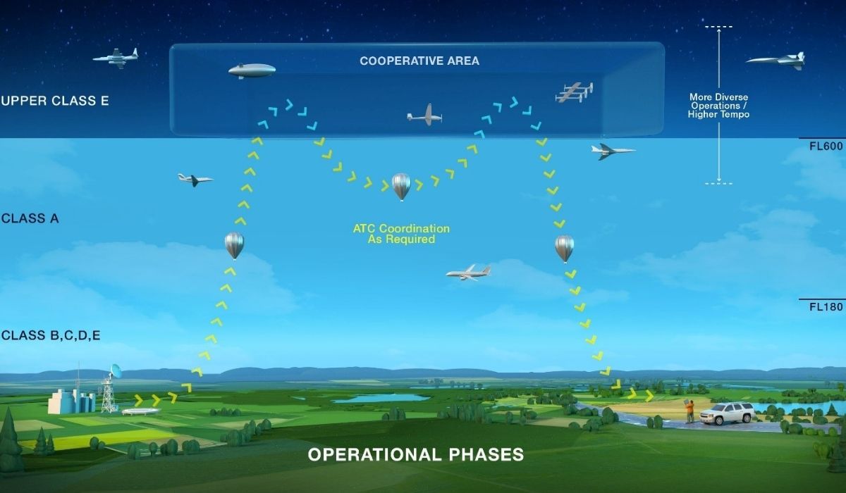
In certain areas, there is also Class E airspace above Flight Level 600 (approximately 60,000 feet MSL).
Class E airspace operates at different altitudes depending on its use.
| Boundary Type | Typical Limit | Purpose |
| Vertical limits (Altitude Boundaries)
Upper Limit |
Up to but not including 18,000 ft MSL |
Marks the top of Class E before Class A begins (FL180) |
| Lower Limit | 1,200 ft AGL | Standard floor in remote/rural areas for en route IFR traffic |
| 700 ft AGL | Common near non-towered airports to support published IFR approach and departure procedures | |
| 0 ft AGL (Surface) | Found only at some non-towered airports with Class E Surface Areas (E2) and published IFR operations | |
| Horizontal Limits | Varies by location and airspace structure | May form circular zones around airports, follow IFR airways, or extend across wide rural regions |
Class E airspace was designed to manage and separate IFR (Instrument Flight Rules) and VFR (Visual Flight Rules) traffic. It allows Air Traffic Control (ATC) to maintain a level of oversight, even when you are outside the controlled zones of Class A, B, C, and D airspace.
Let’s take a closer look at the different types of Class E Airspace:
This type of airspace usually begins at the surface and is usually found around non-towered airports with published IFR procedures.
These surface areas provide controlled airspace from the ground up, allowing for safe takeoffs, landings, and maneuvering near airports.
If you’re flying drones in an E2 surface area under Part 107, you need FAA authorization (via LAANC or DroneZone), just like you would in Class D airspace.
This type of airspace begins at 700 or 1,200 feet above ground level (AGL) and is positioned around airports. It typically allows a safe transition between the airport and higher altitudes to stay within controlled airspace.
Most of this airspace sits above your 400 ft flight ceiling. Flying drones in these areas sometimes requires additional caution and authorization.
E4 airspace consists of narrow extensions stretching out from Class D or Class C airspace to facilitate safe arrivals and departures on a specific route.
Basically, these extensions allow for controlled space in specific directions without expanding the Class D or C airspace.
If you’re flying drones in these extensions at or above surface level, you’ll likely need LAANC approval.
En route airspace is designed to form safe travel corridors when flying at cruising altitudes.
This airspace stretches across the country alongside established airways and provides a safe zone when flying long distances.
It usually starts at 1,200 ft AGL and fills the space between Class G and Class A.
This airspace extends from Flight Level 600 (approximately 60,000 feet) and above. This controlled airspace is used for specialized operations, including military testing and space operations. It ensures separation from commercial and general aviation traffic at lower altitudes.
This airspace is far above the altitude at which drones can operate. Still, it’s helpful to know it exists, especially as drone technology, high-altitude balloons, and near-space platforms continue to develop.
Here’s a table summarizing the Class E Airspace types:
| Class E Airspace Type | Description | Purpose |
| Class E Surface Areas (E2) | Begins at ground level around airports without control towers. | Provides controlled airspace for safe takeoffs, landings, and maneuvering near airports. |
| Class E Transition Areas (E3) | Starts at 700 or 1,200 feet AGL around airports. | Allows aircraft to transition safely between the airport and higher altitudes. |
| Class E Extensions to a Surface Area (E4) | Extensions of Class D or C airspace | Facilitates controlled arrivals and departures along specific routes without expanding Class D or C boundaries. |
| Class E En route Airspace | Covers extensive corridors at cruising altitudes across the country. | Provides safe zones for long-distance flights along established airways. |
| High Altitude Class E (Above FL 600) | Extends from 60,000 feet and higher. | Supports high-altitude operations, space activities, and military testing, keeping them separate from lower traffic. |
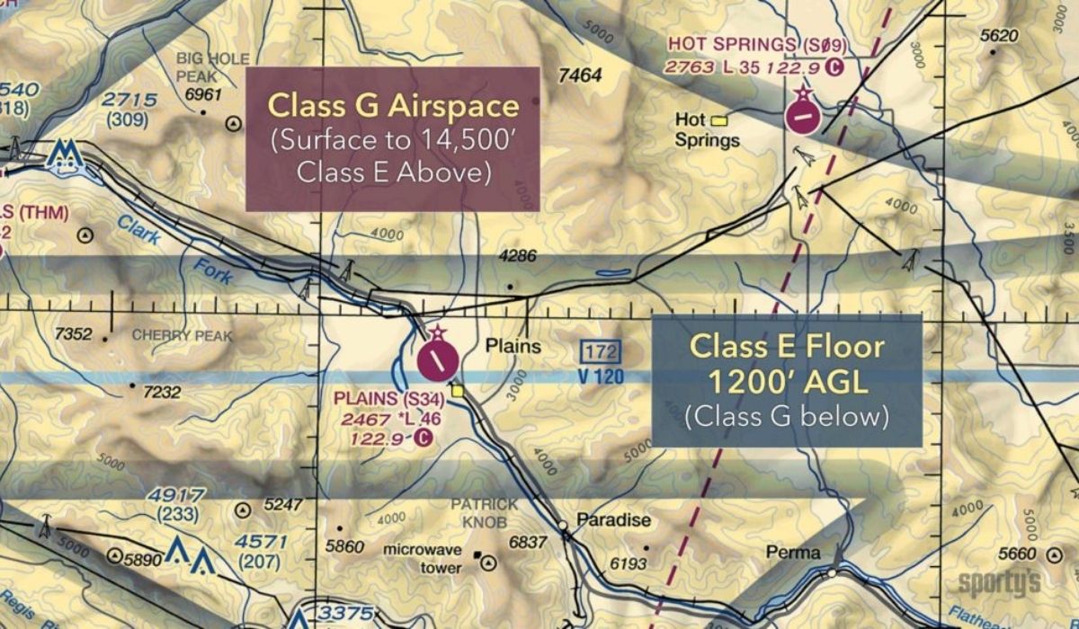
Three important Class E Airspace types are depicted on sectional charts using different color shades and patterns, indicating their boundaries and altitude levels.
Sectional charts symbolize this airspace as dashed magenta lines, indicating that this area is controlled from the ground up.
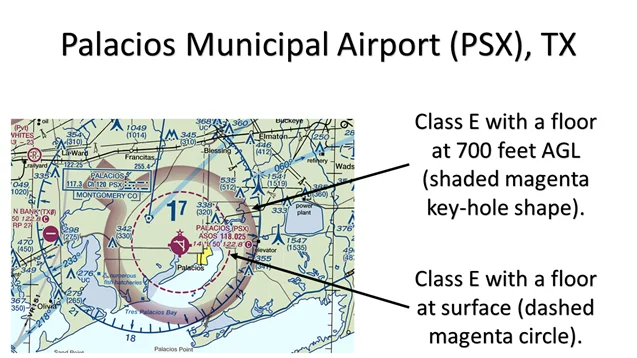
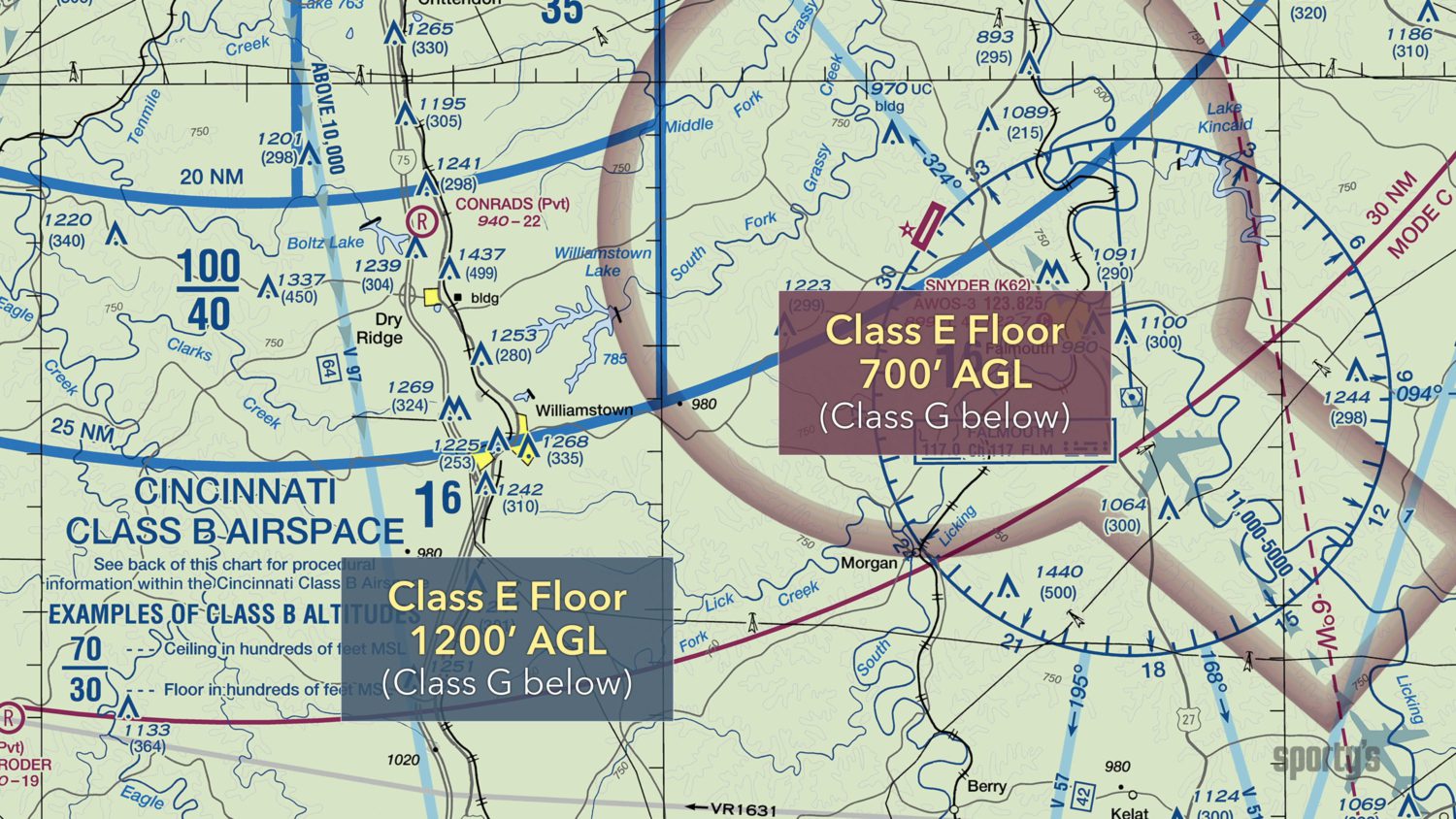
This one can begin from 700 to 1,200 feet above AGL, so it’s depicted in two ways.
| 700 feet AGL | The thick shaded magenta band represents this area, indicating that Class E Airspace starts at 700 feet AGL around near-towered airports. |
| 1,200 feet AGL | The thick shaded blue band represents this area, indicating that Class E Airspace starts at this altitude in areas away from airports. |
No specific boundaries are used, as it often extends across wide airways and has no marked limits.
According to the FAA, Class E Airspace drone pilots must follow weather and visibility requirements to ensure safe flying operations.
As of September 2023, all Part 107 and recreational pilots must operate drones equipped with Remote ID or fly within an FAA-Recognized Identification Area (FRIA). This requirement applies even in Class E airspace.
| Altitude | Visibility | Cloud Clearance |
| Below 10,000 feet MSL | 3 statute miles | Must remain 500 feet below, 1,000 feet above, and 2,000 feet horizontally from clouds. |
| At or above 10,000 feet MSL | 5 statute miles | Must remain 1,000 feet below, 1,000 feet above, and 1 statute mile horizontally from clouds. |
In controlled Class E Airspace near airports, drone pilots may need prior flying authorization through the LAANC (Low Altitude Authorization and Notification Capability).
LAANC provides access to certain Class E surface areas (E2), but only at participating airports listed in the FAA’s LAANC facility map. Not all Class E airports are LAANC-enabled, so availability depends on the specific location.
Most flight planning apps automatically check your Remote ID status and display live weather, NOTAMs, and airspace restrictions in real time. This makes preflight planning faster, but FAA rules still require you to confirm all conditions yourself before flying.
The following are the requirements:
– Aircraft must be equipped with anti-collision lighting visible for 3 statute miles
– Pilots must complete additional night operations training under Part 107
– All other Class E weather minimums still apply
Note: Most drone operations occur below Class E airspace in many areas, as the typical 400-foot AGL ceiling for drone operations often places them in Class G (uncontrolled) airspace.
Class E Airspace might seem complex at first, but once you understand how its altitudes, types, and boundaries work, it becomes a part of your smart flight planning.
In 2026, the FAA continues to enforce stricter drone regulations, and the skies are now shared by more crewed and uncrewed aircraft than ever. Whether you’re flying near a rural airport or operating in a surface Class E zone, understanding the limits is essential for legal and responsible operations.
Apps like B4UFLY make compliance easier. But the rules are your responsibility, not the app’s.
Want to learn more about airspaces, FAA regulations, and essential piloting skills to fly safely near controlled zones?
Explore our drone pilot training programs here.
 2
2
Add Your Comment