Moving Drone No-Fly Zones: New FAA Rules Spark Major Concerns for Pilots

April 9, 2026
| Story Update · March 2026
The situation has worsened since this article was first published. FAA Order 2150.3C Change 13, issued in late January 2026, eliminated enforcement discretion for airspace violations. FAA investigators must now refer qualifying violations directly to the Chief Counsel for legal action, no warnings, no administrative correction path. The original NOTAM is unchanged. The enforcement posture has hardened significantly. See the update log below for the full timeline. |
American drone operators are facing a confusing new challenge that could turn a legal flight into a federal offense in seconds. Since mid-January, the Federal Aviation Administration (FAA) has implemented updated Temporary Flight Restrictions (TFRs) that no longer apply only to fixed locations. These moving drone no-fly zones now follow mobile units from the Department of Homeland Security (DHS), the Department of Defense (DoD), and the Department of Energy (DOE), effectively creating “invisible bubbles” of restricted airspace that travel along with convoys and vessels. How will pilots know or see these moving no-fly zones when operating?
Regulatory Summary
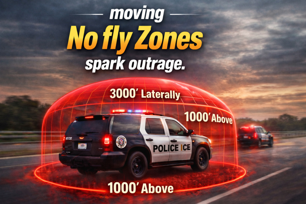
What Is NOTAM FDC 6/4375?NOTAM FDC 6/4375, issued January 16, 2026, bans all drone flights within 3,000 feet laterally and 1,000 feet vertically of any DoD, DoE, or DHS facility or mobile asset, including ground vehicle convoys and their escorts. The restricted airspace is classified as National Defense Airspace. Unlike a standard TFR, it has no fixed location, no geographic boundaries, and no end date. It moves with federal vehicles in real time. There is no public tracking system for where these assets are at any given moment. A pilot flying a legal commercial job can enter restricted airspace without warning if a federal convoy passes within the protected radius. |
What ChangedFrom fixed TFRs to moving no-fly zones |
Who Is AffectedEvery drone pilot in the US |
What To DoLand immediately if you suspect proximity |
Picture this. You’re on a commercial roof inspection, a job you’ve done a hundred times. Before takeoff, you checked B4UFLY, reviewed the TFR map, and ran your NOTAMs. Everything was green. You’re airborne, halfway through the job, when an unmarked DHS van turns onto the street below you. In that moment, your legal flight entered a moving drone no-fly zone and became a federal violation. There was nothing you could have done to prevent it. That’s not a hypothetical. That’s the real operational reality of NOTAM FDC 6/4375.
This is not a standard Temporary Flight Restriction. Standard TFRs have defined coordinates, start times, end times, and appear on flight planning apps like B4UFLY and the FAA TFR map. Pilots check them before every flight. They work because the restricted airspace is fixed and visible.
NOTAM FDC 6/4375 works differently. The restricted airspace exists wherever covered federal assets are located at any given moment. These zones have no published coordinates, no activation alerts, and no public real-time tracking. The FAA cannot post real-time locations of federal vehicles on a public map without creating an operational security risk for the agencies involved.
Here’s exactly what the NOTAM says and why it matters.
| Issued | January 16, 2026, at 1906 UTC |
| Replaces | NOTAM FDC 5/6378 (previous version, fixed facilities only) |
| Agencies covered | DoD, DoE, DHS (including ICE, CBP, Coast Guard) |
| Lateral restriction | 3,000 feet (~0.57 miles) from any covered asset or escort |
| Vertical restriction | 1,000 feet AGL above any covered asset |
| Airspace classification | National Defense Airspace (49 U.S.C. Section 40103(B)(3)) |
| Geographic scope | Nationwide — no boundaries |
| Duration | Indefinite — no end date |
| Appears on flight apps? | No — cannot be mapped without exposing federal agent locations |
| Legal authority | 14 CFR Section 99.7 (Special Security Instructions) |
The drone community’s concern is not about the concept of security airspace around federal assets. It’s about the enforcement of a moving drone no-fly zone that is structurally impossible to comply with in real time
There is no map, no app, and no NOTAM listing that shows you where a DHS convoy is right now. The FAA cannot publish that information without creating an operational security risk for the agencies involved.
The FAA acknowledges this problem. Its own guidance to the SOSC email process returns an acknowledgment and boilerplate that refers pilots back to the same tools that do not show the restriction. The FAA has internally discussed mitigations. As of the most recent update to this article, no public solution has been implemented. The restriction remains in place and unchanged.
| The enforcement change that made this worse: FAA Order 2150.3C Change 13, issued in late January 2026, removed investigator discretion for airspace violations. Previously, an investigator could review a case, determine that the pilot took all reasonable precautions, and exercise judgment. That path no longer exists. Any qualifying violation is now referred directly to the FAA Chief Counsel for legal action. An invisible restriction paired with zero-tolerance enforcement is a structural trap for pilots who did everything right. |
Any commercial drone operator flying in urban or suburban areas where federal agency activity may occur could be affected. That includes common city-based work such as roof inspections, construction monitoring, and real estate photography in areas where DHS or ICE operations may be underway. A moving drone no-fly zone can appear in the middle of any of these jobs with no warning. There is no way to pre-clear a flight area when the restriction is invisible and moves continuously.
Drone as First Responder (DFR) programs are specifically identified as being at risk under this change. Fire and police departments operate in the same urban environments where federal convoy activity may create restricted airspace. A DFR drone responding to a structure fire or a missing person doesn’t have time to assess whether a federal vehicle is nearby.
For a DFR program, “land until you can confirm compliance” is not an operationally viable instruction. The FAA’s guidance assumes a commercial context where missions can be paused. DFR operations don’t have that luxury.
Hobbyist pilots face the same structural exposure as commercial operators. Flying recreationally in a public park, a moving drone no-fly zone can materialize beneath them the moment a federal convoy turns onto a nearby street. Recreational pilots often have less awareness of active airspace regulations and fewer resources to navigate a compliance inquiry.
The National Press Photographers Association and the Freedom of the Press Foundation have both issued statements flagging NOTAM FDC 6/4375 as a First Amendment concern. The restriction makes it illegal to fly a drone anywhere near ICE, CBP, or other DHS operations, which are precisely the activities journalists have the most urgent public-interest need to document from the air. Legal experts have raised questions about whether the NOTAM, as applied, constitutes viewpoint-based suppression of aerial newsgathering.
The FAA classifies the restricted airspace as National Defense Airspace. The enforcement consequences are serious. They are not discretionary since Change 13 removed that pathway.
The drone mitigation authority is explicit in the NOTAM. If you unknowingly enter a moving drone no-fly zone and do not land immediately, your drone may be seized or destroyed. Because the airspace is classified as National Defense Airspace, you may have little or no recourse after enforcement action.
With Change 13 removing the warning path, your preflight documentation is the only thing standing between you and a Chief Counsel referral. Before every flight, check B4UFLY, the FAA TFR map, and NOTAM listings. Screenshot and timestamp each one. If a violation is later alleged, this paper trail proves you exercised due diligence — even when the restriction was structurally invisible to you.
The FAA’s own guidance is clear: if you have reason to believe a covered operation is nearby, land until you can confirm compliance. Don’t try to finish the mission. Land, assess, and verify first. This applies the moment you see federal vehicles in your area, not after they’ve passed your position.
The FAA System Operations Support Center is reachable at (202) 267-8276. Call before flying in areas where federal activity may be occurring. Be aware: as of March 2026, SOSC responses are often boilerplate that refers you back to tools that don’t show the restriction. Document the call regardless. The contact itself is part of your due diligence record.
ICE, CBP, and other DHS agencies operate most actively in cities. If you’re flying commercial work in an urban area, treat any visible federal vehicles as a signal to assess proximity before continuing. Keep your flight path away from areas where convoy activity is visible on the ground.
The FAA is aware of the compliance problem and has discussed solutions internally. No public fix has been published as of April 2026. Monitor the FAA TFR site, Drone U updates, and the update log on this page. When something changes, we’ll post it here first.
This NOTAM does not exist in isolation. It follows a pattern of expanding drone restrictions around federal operations. In October 2025, DHS imposed a 935-square-mile TFR over Chicago during Operation Midway Blitz, the largest civilian drone ban in US history at that point. That restriction had defined geographic limits and an end date. FDC 6/4375 has neither.
For commercial operators and Part 107 pilots, this is a reminder of why staying current on US drone laws and airspace regulations is not optional. The regulatory environment can change rapidly, and the consequences of flying on outdated knowledge are now more severe than they have ever been. The removal of enforcement discretion under Change 13 means there is no longer a warning-first path for pilots who make honest mistakes in a system they cannot see.
The industry is watching this situation closely. The Commercial Drone Alliance, the Drone Service Providers Alliance, and press freedom organizations are all engaged in the moving drone no-fly zone problem. Congressional oversight is a possible avenue. For now, the restriction stands, and the enforcement framework is in place.
| Update Log | |
| Jan 16, 2026 | NOTAM FDC 6/4375 issued.
FAA publishes the updated security notice at 1906 UTC. Replaces FDC 5/6378. Extends mobile asset restrictions nationwide to all DoD, DoE, and DHS mobile assets, including ground vehicle convoys and escorts. |
| Jan 23–27, 2026 | Industry response begins.
Commercial Drone Alliance, Drone Service Providers Alliance, and aviation press flag the impossibility of compliance. FAA acknowledges the practical problem and says internal discussions about mitigations are underway. No solution published. |
| Late Jan, 2026 | FAA Order 2150.3C Change 13 issued.
Enforcement discretion eliminated. FAA investigators must now refer any qualifying airspace violation directly to the Office of the Chief Counsel. Warning letters and administrative correction paths are no longer available for violations. The invisible restriction is now paired with zero-tolerance enforcement. |
| Feb 3, 2026 | First Amendment concerns raised publicly.
The National Press Photographers Association and the Freedom of the Press Foundation both issue statements warning that FDC 6/4375 constitutes a direct threat to aerial journalism. Legal experts flag potential constitutional issues around narrow tailoring and viewpoint-based restrictions on newsgathering near federal operations. |
| Mar 12, 2026 | Analysis confirms SOSC coordination is not working.
Detailed reporting confirms that SOSC email coordination — the FAA’s recommended compliance path — returns boilerplate guidance that refers pilots back to tools that cannot show the restriction. The core NOTAM structure remains unchanged. No public mitigation has been announced. Industry pressure continues. |
| April 2026 | Current status.
NOTAM FDC 6/4375 remains active with no end date. FAA Order 2150.3C Change 13 remains in effect. No public mitigation or compliance tool has been published. The FAA has acknowledged the problem internally. DHS has not indicated willingness to publish asset locations. This page will be updated when the situation changes. |
Until a solution is implemented, the drone industry remains in a state of uncertainty. For now, pilots are advised to exercise extreme caution near any government activity, as moving drone no-fly zones have turned the sky into a moving target for legal compliance.
Understand the full regulatory landscape — start with the evergreen laws hub
