The Future of Construction Drone Technology

June 17, 2025
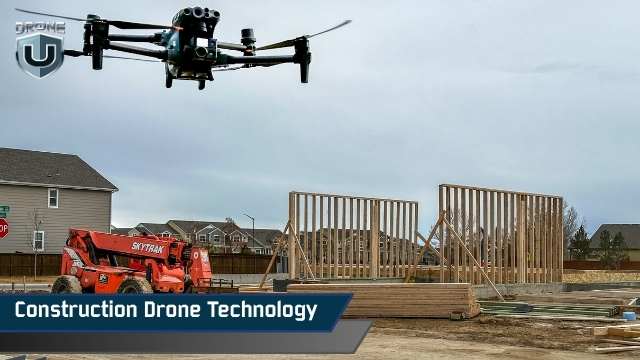
Drones are changing how construction projects are pitched, tracked, and delivered.
Talking about the future of drones in construction, there is a lot to uncover. And it is limited to tracking construction progression or land surveying.
We are talking about much more advanced construction drone technology, such as immersive visualizations, BIM overlays, and using tools like Unreal Engine.
This article, drawn from a candid conversation between Brian Owens and Paul from Drone U, explores the practical, tactical, and deeply human journey of how construction drone technology is redefining workflows across the industry.
Whether you’re a drone service provider looking to break into construction or a contractor still relying on progress photos from the ground, this story will provide you with the roadmap.
First, let’s find out who Brian Owens is and why mentioning him in this article is so important.
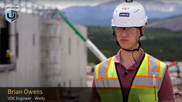
Brian Owen’s- VDC at The Weitz Company
Brian isn’t your typical drone pilot. He’s a mechanical engineer, a lifelong tinkerer. Today, he serves as VDC Engineer II at The Weitz Company, where he leads field solutions.
Brian Owens grew up milking cows in Eagar, Arizona. Never thought of a career in construction technology.
His curiosity showed up early. He pulled apart anything with wires or moving parts and usually put it back together, learning something new each time.
By high school, he was living in Idaho and building robots. He ran the 800-meter race with the same grit that would later fuel his success in tech and engineering. After a two-year mission in Hawaii, Brian earned his mechanical engineering degree from BYU–Idaho. While in school, he immersed himself in mechatronics, a discipline that combines mechanical and electrical engineering.
That’s when he asked his wife, “Can I spend a few hundred bucks to build a drone?”
She said yes. That hobby quickly evolved into a professional pursuit.
Brian taught himself to fly FPV drones through trial and error. What began as a side project to learn electronics evolved into a passion that sharpened his instincts for modeling, simulation, and spatial data.
If you had told Brian during college that he’d end up in construction, he probably would’ve laughed. He pictured himself designing products, not buildings. But fate had other plans.
It started with a flight, just not the drone kind.
Joshua Marriott, Director at The Weitz Company and Drone U alum, happened to sit next to Brian’s father-in-law on a plane. They struck up a conversation about drones and engineering. That talk led to introductions. Over the next six months, Brian and Joshua stayed in touch.
As graduation approached, Brian had job offers from several companies. But he held out for the Weitz. And the Weitz did something unusual. They didn’t just hire Brian. They created a role specifically for him.
Officially, he joined as a VDC (Virtual Design and Construction) Engineer. Unofficially, he became the go-to person for drone tech, laser scanning, and robotic field solutions.
In his new role, he quickly saw the potential to do more than fly drones or model structures. He became a connector. He linked tools, teams, and data. His goal was to bring real-world construction and digital design into tighter alignment, using drones as the bridge.
And that is how the future of drones in construction begins taking shape.
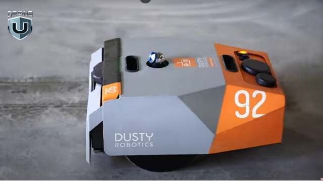
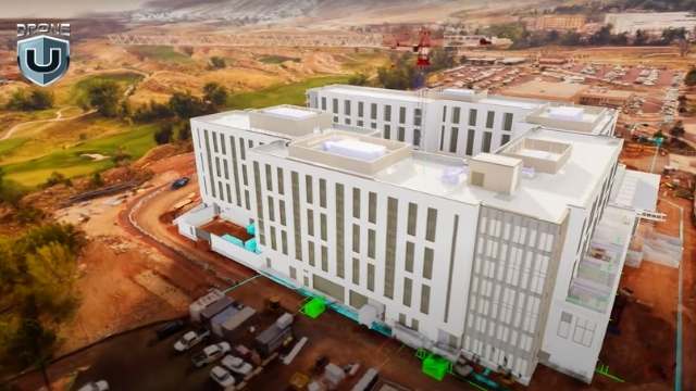
Dusty Robotics Field Printer
When you hear “construction,” your mind might go to hard hats and cranes. But for Brian Owens and the Field Solutions team at Weitz, the real action starts with scanners, robots, and drones.
Together, these tools create a smooth, end-to-end digital workflow.
Here’s what that looks like.
One of the most critical tools in Brian’s tech stack is the laser scanner. These devices emit light pulses and record the time it takes each pulse to reflect from surrounding surfaces. The result is millions of precise data points that form a 3D “point cloud.”
It’s like having X-ray vision for buildings. The scanner helps teams measure site conditions, verify installations, and catch errors before they turn into costly rework.
The Dusty field printer is a wheeled robot that reads architectural plans to print layouts directly onto the jobsite floor. It marks outlines for walls, plumbing, and even overhead Mechanical, Electrical, and Plumbing (MEP) systems. The robot moves with sub-inch accuracy and uses total stations that sync with the digital model.
This process reduces measuring time, lowers the chance of layout errors, and keeps design and field execution closely aligned.
Brian uses Navisworks for model coordination and Unreal Engine for photorealistic rendering. Unreal allows the team to blend drone-captured site data with BIM models. Stakeholders can toggle between the current progress and the final design.
“It’s like giving someone a time machine,” Brian said. “You can show them what’s physically built today and what it’s going to look like in the future.”
The Mavic 3 Enterprise drones handle most jobs. FPV rigs capture cinematic flythroughs. DJI Mini drones are perfect for indoor scans and tight spaces. Brian’s team flies missions for mapping, inspection, safety, estimating, and stakeholder updates.
But the power doesn’t stop at the hardware. The team processes orthomosaics in DroneDeploy, overlays PDFs, and utility data. It also generates custom 3D models and splat renders. The result is high-quality visuals that everyone on the jobsite can use, understand, and act on.
This approach to construction drone technology ensures drones are embedded into every phase, not just as tools for visuals, but as engines for insight.
So, how do drones fit into the day-to-day of a construction project?
Let’s explore that in the next section
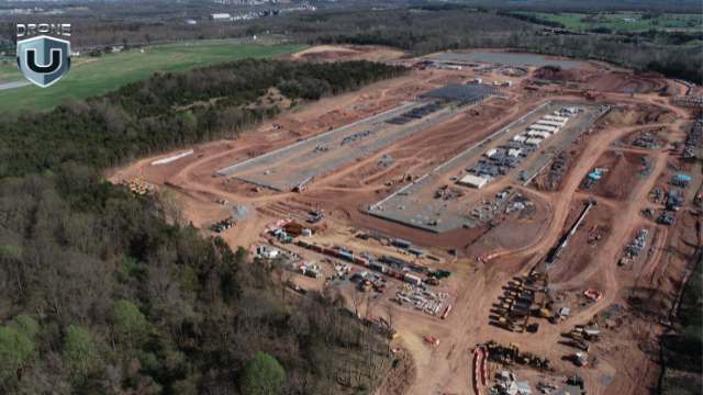
Mapping the Construction Site
To Brian Owens, drones are a standard. Not an extra line item, but a core operational tool. And their value compounds across every phase of a project.
Before a shovel hits the ground, drones are already in the air.
Brian and his team use drones to map potential sites during the pursuit phase. They capture topography, identify access points, and help estimate logistics, cut-and-fill requirements, and travel paths.
It’s not just about flashy visuals. It’s about giving estimators, developers, and decision-makers the real-world context they need to submit accurate, competitive bids and win the job.
Once a project moves forward, drones help fine-tune logistics.
Brian’s team uses drone-generated maps to plan staging zones, evaluate soil conditions, and overlay utility lines. They even help teams align penetrations before pouring concrete.
In some cases, a simple orthomosaic image can prevent a costly mistake by revealing a misaligned trench or misplaced slab layout.
This is where drones prove their worth.
“We try to fly weekly,” Brian says. “It’s risk management, pure and simple.”
Drones capture as-built conditions with time-stamped and geo-referenced images.
So when a client claims, “This wasn’t installed on time,” the project team can pull up drone data and show exactly when work was completed. It creates a visual record that’s both permanent and indisputable.
Drones also improve safety and utility coordination. Teams overlay underground utility plans onto drone maps to prevent cable strikes. They use drones for façade inspections that would otherwise require dangerous lift work.
They also provide regular updates for both internal teams and external stakeholders.
By the end of the project, the drone footage evolves from simple documentation into a compelling narrative.
With FPV flythroughs, cinematic edit reels, and splat models, Brian transforms technical captures into powerful communication tools.
Marketing teams use visuals to showcase their work. Project managers present them in stakeholder briefings. Executives use them to pitch future phases or pursue new opportunities.
Great flights mean nothing without great deliverables.
Are you still wondering what kind of drone outputs are used on a jobsite and which ones truly impress?
We’ll analyze that in the upcoming section.
Splat Models
Brian Owens is clear on one thing: drone data only matters if it’s usable. And that starts with deliverables that teams rely on.
Here’s how he makes the data count.
Every drone flight at Weitz begins with an orthomosaic map. It’s not optional. These high-resolution, geo-referenced images serve as a shared source of truth. Teams use them to monitor progress, resolve disputes, verify timelines, and support inspections.
“They’re used every day,” Brian said. “From QA and QC to owner updates, orthos are the foundation.”
Brian’s standard workflow also includes ISO photo loops, which are angled perimeter shots and orbit-style video captures.
These files go into a shared cloud folder, where marketing teams, executives, and project managers can access and use them as needed.
Some projects take it a step further with edited video updates. These combine aerial loops, ground-level shots, and interior walkthroughs into short, documentary-style summaries.
These videos serve as biweekly progress reports for larger clients, which are easier to understand and share than a PDF or traditional reports.
Brian recently added something new to his toolkit: Gaussian splat models. These are highly photorealistic 3D scenes built from drone images and video.
“It’s like photogrammetry, but more realistic,” he explained. “The trees look better, the steel looks better. Everything just pops.”
But he doesn’t stop there. Brian overlays BIM models into the splat environment using Unreal Engine. This allows clients to see both the current build and the final design in one seamless view.
Once the splat model is built, his team hosts it online and shares a secure link. Teams, stakeholders, and even community members can explore the model from any browser.
No special software or downloads required.
None of this works at scale without the right people and culture behind the tools. Let’s break down how the Weitz Company built a 40-drone pilot program.
The Weitz Company Logo
At a company the size of Weitz, with more than 1,400 employees and dozens of active job sites, scaling drone operations takes more than buying hardware. It requires a mindset shift. That’s where Brian’s role extends beyond engineering.
Today, Weitz has over 40 drone pilots operating across national projects. Most of them are project managers, engineers, and superintendents who integrate drones into their day-to-day work.
“It’s like 5% of their week, maybe,” Brian said. “But they use the data every single day.”
To support them, Weitz has built a clear command structure for its drone program. Each business unit designates a drone champion. That person handles training, oversight, and helps keep pilots up to speed.
Every quarter, pilots attend mandatory training sessions. Monthly meetings keep drone champions aligned. And when issues come up during the week, Brian stays on call to help.
Brian knows that influence grows with trust.
He treats every internal team as a client. For him, every jobsite interaction is a chance to show how drones can solve problems, not just capture progress photos.
Whether it’s a BIM overlay or a pre-concrete flyover, Brian and his team deliver drone data as a service. And the more teams see the results, the more they want in.
“We’ve got superintendents who didn’t care about drones two years ago,” he said. “Now they’re asking for splat models every week.”
Unlike many enterprise programs, Weitz doesn’t enforce a minimum flight hour policy. Instead, the company fosters a culture built on mentorship, support, and steady communication.
Brian doesn’t focus on enforcing rules. He focuses on sparking curiosity. Once people see what drones can do, they rarely need convincing.
Brian Owens doesn’t just fly drones. He thinks like a product designer, codes like a tinkerer, and pitches like a creative director. That blend is shaping what comes next, not just for The Weitz Company but for the entire construction industry.
Drone media in construction used to focus on documentation: maps, photos, and maybe a timelapse if the marketing team got involved.
But Brian sees a shift.
Clients no longer want raw data. They want clarity. They want to walk through a project before it’s built. They want to compare real-world conditions to the BIM model in real time. They need spatial context, not just 2D drawings.
That’s where construction drone technology, paired with tools like Unreal Engine and Gaussian splatting, creates a new layer of communication.
Brian envisions a world where anyone, from owners and stakeholders to city officials, can open a secure link, toggle between aerial views and 3D models, and explore the site virtually. There’s no login required, no software to install. Just fast, frictionless visibility.
Picture this: you’re a developer. Instead of asking for a progress update, you open a dashboard that shows the live site, last week’s drone overlay, and the BIM schedule, all in one place.
That’s the kind of experience Brian is building.
For Brian, usefulness is the goal.
“If no one’s using it,” Brian said, “it doesn’t matter how cool the flythrough is. It’s wasted effort.”
His goal isn’t just better visuals. He’s creating tools that drive decisions. That’s why he focuses on standardizing deliverables, streamlining workflows, and plugging drone outputs directly into platforms that teams already rely on.
Drone media, in his hands, becomes more than just content. It becomes operational intelligence.
Thinking about using your drone skills in construction? Brian has some hard-earned advice.
For drone pilots hoping to work in construction, Brian’s message is simple: know your craft, but more importantly, know your audience.
“Flying the drone is the easy part,” Brian said. “Knowing what deliverables to give, when to give them, and how to make them useful. That’s what separates a good pilot from someone who’s just flying a drone.”
You don’t need every certification or the latest drone. What matters is understanding what project managers, VDC engineers, and superintendents need.
Most of the time, that means orthomosaics, PDF overlays, clean photo loops, and data they can drop into tools like Procore or Bluebeam.
If you want to get hired, start by learning how construction teams think and talk.
That means understanding rebar layout, submittals, MEP sequencing, and why teams fly before a concrete pour.
Brian recommends walking job sites, asking questions, and watching how decisions get made in the field.
Yes, Brian builds cinematic splat models and Unreal overlays. But he didn’t start there. He earned trust by solving real problems: faster layout, better documentation, fewer mistakes.
“You could have the coolest looking deliverable in the world,” Brian said, “but if your client doesn’t know how to use it, what’s the point?”
Construction changes constantly. Technology moves fast. What worked last year might be irrelevant today.
That’s why Brian encourages new pilots to stay curious, test workflows, crash a few drones, and keep asking, “What problem am I solving?”
And “If you want to break into construction,” Brian said, “don’t send a cinematic reel. Send a PDF with usable deliverables. Show a good orthomosaic, a photo loop, and explain how it helped someone make a decision.”
Construction drone technology isn’t just about flying smarter. It’s about thinking deeper. Knowing when to map, what to deliver, and how to plug into the decisions that matter.
And I think that’s the bigger takeaway from this article.
If you’re a drone pilot trying to find your place in the industry, take a page from Brian’s playbook: start with the problem, deliver with purpose, and never stop learning.
Because in the future of construction, the best drone pilots won’t just fly. They’ll build.
Are you ready to lead drone operations on real construction sites?
Explore Drone U’s Construction Bundle and learn the exact skills top contractors look for.
