
Infrared vs Thermal Imaging Drones: Key Differences Explained (2026)

June 20, 2026
Quick Answer: Thermal vs Infrared Imaging DronesThermal imaging detects heat that objects emit. Infrared imaging detects light reflected off surfaces. They are not the same technology.
|
Ever wondered how drones can spot people in complete darkness or detect hidden heat leaks in buildings?
People who fly drones for inspections, public safety, or field work often use ‘thermal‘ and ‘infrared’ as if they mean the same thing. They don’t.
Choosing the right sensor matters. Tracking a missing person at night and diagnosing failing equipment each need a different type of imaging.
Thermal imaging reads the heat objects emit, while infrared imaging captures reflected light in specific IR wavelengths. They sit close together in the spectrum, but once you’re airborne, they behave very differently.
Understanding this difference helps you avoid a bad purchase and read your data correctly. It also makes it easier to compare drone thermal cameras across different models and mission types.
Whether you’re inspecting power lines, detecting heat leaks in buildings, or monitoring agriculture, thermal imaging gives you details that a regular RGB camera can’t capture.
This guide covers how thermal imaging works, how it differs from infrared, when to use each, and what to look for in a drone setup.
Infrared refers to a range of electromagnetic radiation that sits just beyond visible light. While human eyes detect light in the 400–700 nanometers (nm) range, infrared begins just above that and extends from about 700 nm to 1 millimeter (mm). Inside this band are several smaller ranges, each used for different types of imaging.
Thermal imaging is one part of the infrared spectrum, not a separate technology. All thermal cameras are infrared devices, but not all infrared devices measure heat. Some detect only reflected light, while others measure emitted radiation.
Here’s a simple breakdown of the key infrared bands:
| IR Band | Typical Range (Approx.) | What It Detects | Common Use in Drones |
| Near Infrared (NIR) | ~700–1,400 nm | Reflected sunlight | Agriculture (NDVI), vegetation stress analysis |
| Short-Wave IR (SWIR) | ~1,400–3,000 nm | Reflected + some emitted | Fog/smoke penetration, mining, surveillance |
| Mid-Wave IR (MWIR) | ~3–5 µm | Emitted thermal radiation | High-end military, gas leak imaging |
| Long-Wave IR (LWIR) | ~8–14 µm | Emitted thermal radiation (heat) | Most commercial thermal drones (fire, utilities, inspections) |
Thermal imaging drones usually operate in the LWIR band. This band detects the heat that objects emit naturally. It works well for spotting heat from people, buildings, terrain, and machinery. It also works without any external light.
NIR and SWIR work differently. They rely on reflected light rather than emitted heat and are useful for capturing textures and materials. However, they cannot measure the true temperature.
Thermal imaging captures temperature differences using long-wave infrared radiation, typically in the 8–14 µm range. This part of the spectrum measures heat that objects emit, not reflected light. That is why thermal cameras work in darkness, smoke, and fog.
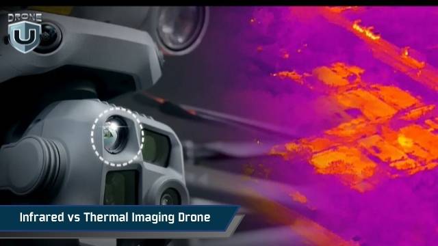
A thermal camera converts this heat into a visual image called a thermogram, where warmer areas appear brighter and cooler areas appear darker.
For example, a damaged solar panel cell may appear brighter because it releases more heat than surrounding cells, even if it looks perfectly normal to the human eye.
Thermal cameras come in two forms:
Sensor resolution also affects image quality. A 640×512 sensor captures far more detail than a 320×256 sensor. That extra detail helps you spot small cracks, faint hotspots, or distant targets. Higher resolution also reduces pixel stretch and improves accuracy during reporting.
Now that we’re clear what thermal imaging is, let’s see how it compares to other infrared technologies.
Thermal and infrared imaging may seem similar, but they serve very different purposes on drones. Here’s a clear comparison:
| Feature | Thermal Imaging | Infrared/Non-Thermal Imaging |
| What it detects | Detects the heat that objects naturally emit. | Detects light that is reflected from surfaces. |
| Requires light? | Does not require any external light and can operate in complete darkness. | Requires sunlight or an IR light source to capture reflected infrared. |
| Wavelength range | Long-wave infrared (7.5–14 µm) | Near-IR or short-wave IR (0.7–3 µm) |
| Image output | Produces a thermogram that highlights temperature differences across surfaces. | Produces an image showing surface details based on reflected infrared light. |
| Best uses | Ideal for night operations, smoke/fog, search & rescue, heat leak detection | Vegetation monitoring, material analysis, surface mapping |
| Temperature measurement | Radiometric thermal cameras provide precise temperature readings for each pixel. | Infrared imaging cannot measure temperature; it only shows relative reflectance. |
| Advantages | It can detect heat patterns in low-visibility conditions and highlight hotspots that are invisible to the naked eye. | It provides detailed surface imagery, showing textures and material differences that thermal imaging cannot. |
| Limitations | It shows less visible detail and cannot provide information about surface reflectance. | It cannot detect heat, making it ineffective in total darkness or through smoke and fog. |
In short, Thermal is better when the goal is to find heat. Infrared is better for analyzing reflectance or surface properties. Both can be mounted on drones, but the choice depends on the mission.
For reference, commercial thermal drone payloads typically detect temperatures from -40°F to over 1,000°F (-40°C to 550°C), with sensor resolutions ranging from 160×120 for entry-level units up to 640×512 for professional-grade payloads like the DJI Zenmuse H30T or FLIR-equipped systems. Entry-level thermal drones start around $2,500, while radiometric professional payloads can exceed $10,000.
Choosing between thermal and infrared imaging depends on what you need to see and measure.
Thermal cameras detect heat, so they’re best for missions where temperature differences matter. They work in darkness, smoke, and fog. Ideal uses include:
Infrared cameras that detect reflected light are better for analyzing surfaces and materials. They require illumination (sunlight or IR light). They’re commonly used for:
Some missions need both temperature and surface detail, and that’s where hybrid systems come in.
Some drones combine multiple sensors, typically thermal, infrared, and visible-light cameras, in a single payload. These hybrid systems give pilots a complete view of both heat patterns and surface details at the same time.
A hybrid drone can show a hotspot on a roof with its thermal camera. At the same time, it can capture the roof’s structure with a visible-light or infrared sensor. This makes each inspection faster and more accurate. You don’t need to fly separate missions with different sensors.
Hybrid systems also improve decision-making in complex environments. For example, in search-and-rescue operations, the thermal sensor can detect a person’s heat signature. The visible or IR camera can then show obstacles, terrain features, and landmarks. This provides the pilot with more context and improves mission safety.
Data from hybrid drones is often combined into one fused image or map. This view pairs thermal imaging’s temperature data with the surface detail from infrared or visible-light sensors.
In simple terms, thermal shows heat patterns and highlights hotspots or people. IR shows textures and surface features. You can see both temperature information and material detail in a single flight. This improves situational awareness and removes the need for repeated missions.
Choosing a hybrid system depends on the job. If you need simultaneous temperature analysis and clear visual detail, a dual-sensor drone is usually the most efficient choice.
Every mission demands a different tool, so let’s break down how to select the right drone and sensor combination.
Choosing the right thermal imaging drone and sensor setup can be overwhelming. The key is to match your equipment to the mission, environment, and data type you need.
Here’s a simple breakdown of the main factors to help you select the best setup for thermal, infrared, or hybrid drone operations.
Choose whether your mission requires thermal imaging, infrared, or a hybrid system.
Higher-resolution sensors give cleaner, more accurate images.
Make sure your drone can handle the sensor’s weight without losing stability or flight time. Dual-sensor payloads often require:
Think about the environment where you’ll fly:
Choosing the right combination of drone and sensor ensures your mission is efficient, safe, and delivers the data you need.
Understanding the difference between thermal and infrared drones helps you choose the right tool for your work.
A thermal imaging drone detects emitted heat and is ideal for search-and-rescue, firefighting, and industrial inspections.
An infrared drone detects reflected IR light, which is useful for analyzing surfaces, vegetation, and materials. Hybrid systems provide both heat information and surface detail in one flight.
When you choose a drone, start with your mission goals. Then look at the sensor type, resolution, payload capacity, and environment you’ll be flying in. The right setup improves accuracy, efficiency, and safety. Once you understand these differences, choosing the best thermal imaging drone or a hybrid system becomes much easier.
Ready to upgrade your drone fleet?
Explore the best thermal drones and find the right setup for your missions.
 2
2