Top 10 Thermal Drone Applications in 2025
October 31, 2025
What if you could see heat, not just light? What if you could see a failing solar cell, a hidden fire hotspot, or a missing person in total darkness before anyone else can?
It is the magic of a thermal drone. Instead of relying on what your eyes can see, it uses infrared sensors to capture temperature differences and reveal critical details you’d otherwise miss.
From mapping solar farms and inspecting power lines to monitoring crops or supporting emergency crews, a thermal drone helps you make faster, smarter, and safer decisions in the field.
In this guide, we’ll walk you through the top 10 real-world applications of thermal drones and explore the various ways each one is changing how industries operate today.
Let’s first understand how a thermal drone works.
Where a normal camera captures light, a thermal camera captures heat.
Every object emits heat energy, known as infrared radiation. The drone’s sensor detects this energy and turns it into a thermal image. Warmer areas appear in red or orange, and cooler zones in blue or purple.
This “heat map” highlights patterns you can’t see with the naked eye, like a hot electrical connection, a weak solar panel, a missing person at night, or creatures running around.
If it gives off heat, you can see it.
Mounted on drones, these sensors scan large areas in minutes. You can inspect roofs, power lines, or fields without stepping into dangerous or hard-to-reach places.
Modern thermal drones also include a regular camera. You can switch between visual and thermal views or combine them to get a clearer picture of the problem.
Advanced models take the capabilities further with radiometric sensors and AI tools that record accurate temperatures for each pixel. This lets you measure and analyze the data later to create highly detailed inspection reports.
In short, a thermal drone turns invisible heat into useful information. It helps you find issues early, save time, and make safer decisions whenever you fly.
If you already use drones in your operations, adding a thermal drone can completely change how you see and solve problems. With one flight, you can spot electrical faults, insulation leaks, or overheating equipment without sending crews into risky areas.
Instead of climbing towers or walking long stretches of solar panels, a thermal drone can scan the entire site in minutes and pinpoint precisely where attention is needed.
Thermal drones make operations safer. In high-risk areas like fires, disaster zones, or industrial sites, they help you spot danger before entering. From helping search teams find missing people through vegetation cover to plant operators being able to detect overheating machines before they fail, these insights save lives and time.
They also improve data accuracy. Modern thermal drones sync with mapping and AI tools to generate reports, track temperature trends, and plan maintenance automatically. In industries where downtime is costly, that foresight quickly pays off.
According to a Market Research Future report, the global thermal drone market is expected to grow at a CAGR of 11.48% from 2025 to 2035. That growth reflects a simple truth: when you can see the unseen, your entire workflow improves.
With these advantages, it’s easy to see why more industries are adopting thermal drones. Let’s look at the top real-world applications where thermal drones are making the most significant impact.
Thermal drones are transforming how professionals work across industries. From emergency response to industrial inspections, these drones use thermal data to give operators a new layer of intelligence.
Here are 10 real-world applications where they’re making a measurable difference:
When lives are on the line, time is everything. Thermal drones help rescuers locate missing people more quickly and with reduced risk.
Poor visibility, whether due to darkness, smoke, or dense terrain, often slows traditional searches. A thermal drone detects body heat instead of light, allowing teams to spot people that would otherwise remain hidden.
Imagine trying to find a lost hiker in a wooded area after sunset. The trees block most of the view, and flashlights don’t reach far. A thermal drone can fly overhead, scanning the terrain and instantly flagging warm spots that could indicate a human presence. Operators can then zoom in, confirm with a visual feed, and guide ground teams to the exact location.
Agencies like the Los Angeles County Sheriff’s Department now deploy thermal drones in search and rescue missions across mountainous regions at night. They first scan large areas using thermal drones before sending ground teams in.
Thermal drones are also effective in disaster zones, especially after earthquakes, floods, or building collapses. When survivors are trapped under debris, their body heat can still register on a thermal camera. Combined with AI-powered detection, the drone helps rescuers quickly identify human heat signatures and direct resources precisely where needed.
Consequently, responders can better avoid unstable or dangerous areas, speed up searches, and reduce the risks rescue teams face.
Fire is unpredictable. It spreads fast, changes direction with the wind, and can hide danger beneath the surface. Thermal drones give firefighters a clear view through smoke and heat, improving safety and response speed.
They detect temperature differences across burning or smoldering areas, helping crews identify where a fire is spreading.
Departments across the U.S. are integrating thermal imaging into standard operations. The Austin Fire Department uses thermal drones to monitor warehouse fires to enhance firefighter safety and situational awareness. Similarly, California’s Department of Forestry and Fire Protection (CAL FIRE) uses thermal drones to map wildfire perimeters and detect hidden hotspots.
Beyond suppression, thermal data support post-fire analysis and investigation. Radiometric readings reveal how a blaze moved and where it started, information essential for insurance and safety audits.
Pairing thermal imaging with GIS mapping in wildland fires gives teams a clear aerial view of fire lines and heat zones. What once took hours in a helicopter can now be done in minutes with a thermal drone. It’s faster, cheaper, and much safer for the crew.
Thermal drones give fire crews faster insight and safer working conditions. They also provide a clearer view of the situation while cutting the cost and time needed compared to manned aircraft.
After a disaster, roads are blocked, buildings collapse, and conditions for rescuers become unsafe. A thermal drone can launch immediately, giving teams a clear view from above. When communication lines fail or visibility is poor, these drones detect body heat under rubble, locate survivors in floods or landslides, and spot hidden fire zones.
During the 2023 Turkey–Syria earthquake, rescue teams used thermal drones to scan collapsed buildings. The drones helped locate survivors trapped beneath debris and allowed rescue teams to focus their efforts where they mattered most.
Thermal drones are also vital during recovery. After floods or hurricanes, they detect moisture in buildings and find damaged transformers or power lines faster than ground crews. Aid agencies use them to see which areas still have power or heat at night, ensuring relief reaches those in need.
By reducing risk to responders and giving real-time data, thermal drones turn confusion into clarity, helping teams save lives, assess damage, and rebuild faster.
Thermal drones provide police and security teams with visibility that the human eye can’t achieve. When it’s dark, foggy, or smoky, these drones detect heat signatures that stand out sharply against their surroundings.
During pursuits, officers can fly a thermal drone overhead to spot suspects hiding behind fences, open fields, or under vehicles. Instead of searching blindly, ground teams receive live coordinates and can move in with precision and safety.
Police departments across the U.S., such as the Chula Vista Police Department, now use drones as first responders. They use thermal imaging to monitor unfolding situations before officers arrive, cutting response times and reducing risk.
The Pasco County Sheriff’s Office in Florida used thermal drones to find a burglary suspect hidden in dense woods at night.
Thermal drones also monitor large crowds and events, identifying hotspots that may signal congestion or medical distress. For border patrol and facility security, they offer 24/7 surveillance, even during blackouts.
Some departments also use them in hazardous zones, such as chemical plants, to detect intruders or leaks without risking officers’ safety.
Used responsibly, thermal drones improve public safety, giving law enforcement real-time awareness and control in critical moments.
Inspecting powerlines is risky and slow. Workers must climb towers and operate near live electricity. Thermal drones make this process safer and faster by spotting heat differences that show faults, such as loose connections or overheating.
Utilities in California, such as Southern California Edison (SCE), use thermal drones to inspect power lines in high-fire-risk areas. These drones capture detailed images of poles, wires, and other components to identify potential ignition sources before they cause damage.
By replacing manual inspections with aerial surveys, utility teams can assess more infrastructure faster and more accurately. The data collected helps maintenance crews prioritize repairs and prevent outages or wildfires. This proactive approach reduces inspection time and strengthens safety for field workers and surrounding communities.
With AI-powered analysis, utilities now predict and prevent faults before outages occur.
In short, thermal drones are transforming the power sector by improving safety, reducing downtime, and cutting inspection costs.
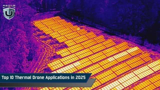
Solar farms cover vast areas with thousands of panels. Inspecting them manually takes days. Thermal drones make this process quick and accurate. Every panel gives off heat, and any malfunction creates a discernible temperature pattern.
Drones like the DJI Mavic 3T scan entire solar fields in minutes, highlighting hotspots, cracks, and faulty connections. Software such as DroneDeploy or Pix4D converts this data into thermal maps, helping crews fix problems immediately.
Thermal scans are also used during installation to verify panel performance and damage checks after storms.
Regular drone inspections are crucial in helping energy providers track long-term efficiency and prevent costly energy loss.
Inspecting roofs is dangerous and time-consuming. A thermal drone makes it safer and more efficient. It detects heat loss, leaks, and insulation issues that can’t be seen with the naked eye.
A DJI Mavic 3 Thermal can scan a commercial roof in minutes, producing a detailed thermogram highlighting problem areas. We produced a guide on the best drones for roof inspection that you may find helpful when picking out the right machine for the job.
Warm spots may show trapped moisture or leaks, while cool spots can reveal missing insulation. Contractors use this data to plan precise repairs, saving money and avoiding unnecessary roof replacements. Building managers find them convenient for checking energy efficiency through walls, windows, and doors.
Likewise, insurance companies use them to assess roof damage safely after storms. The thermal images provide solid proof for claims while speeding up the assessment process. By offering clear, measurable proof of damage, they reduce risks for inspectors while minimizing disputes between policyholders and insurance providers.
Mining and industrial sites are some of the most challenging environments to work in, with extreme heat, heavy machinery, and ongoing safety risks. Thermal drones help teams see what’s happening in these harsh environments without putting anyone in danger.
In mining, they’re used to spot overheating in machinery, conveyor belts, and motors before failures occur. After an explosion or blasting event, drones can scan for leftover heat spots or unspent explosives, keeping crews safely out of harm’s way. Subtle temperature differences in the ground can even reveal water seepage or movement that signals potential instability.
Thermal drones inspect flare stacks, boilers, and pipelines in refineries and factories while production continues. For example, an oil refinery might deploy a DJI Matrice 350 RTK to monitor flare stacks and detect leaks before they escalate.
When paired with AI analytics, thermal data can provide actionable insights such as highlighting abnormal temperatures, automating maintenance alerts, and improving uptime.
By catching minor issues early, thermal drones help industries cut risks, reduce downtime, and extend the life of expensive equipment.
Thermal drones are now essential tools in modern farming. They detect temperature differences in crops that reveal stress, disease, or poor irrigation, long before visible damage appears.
Healthy plants release moisture, keeping their leaves cool, while stressed plants tend to retain heat. By mapping these temperature changes, drones help farmers identify dry or unhealthy zones.
In drought-prone areas like California or Texas, thermal drones guide irrigation and water use. They’ve also found applications in vineyards and orchards, where they monitor canopy temperature and plan harvest timing.
If you’re exploring drone options for precision farming, check out our guide on the best agricultural drones to find models suited for your needs.
Livestock farmers use them too, as changes in body heat can reveal early signs of illness or heat stress.
Using platforms like Pix4Dfields or DroneDeploy, farmers can process drone data the same day and take quick action.
Thermal drones save water, increase yield, and make farming smarter, and have become a necessity for modern precision agriculture.
Thermal drones help scientists and conservationists monitor wildlife and ecosystems, even in darkness or thick vegetation. They detect body heat, allowing researchers to track animals without disturbing them.
In Florida, biologists use thermal drones to track manatees and alligators. In Montana, they monitor elk herds during migration. Rangers in national parks use them to spot poachers by detecting human heat signatures at night.
Thermal drones also monitor habitat health. They detect temperature changes in rivers and forests that signal pollution, drought, or deforestation. After wildfires, they locate surviving animals and hidden hotspots that could reignite fires.
Even in cities, they help rescue teams find lost pets or injured animals in hard-to-reach places.
When matched with its intended task, a thermal drone can be non-invasive, safe, and efficient. It’s become a vital tool in conservation, turning invisible life and heat into visible, actionable data.
Next, let’s explore some of the best thermal drones available today.
Choosing the right thermal drone comes down to your workflow, not just specs. The best model for a home inspector isn’t the same as what a utility engineer or firefighter might need. The key is matching performance, payload, and portability with your mission goals.
For compact and quick-deployment operations, drones like the DJI Mavic 3 Thermal or Autel EVO II Dual 640T V3 are solid choices. They’re easy to transport and deploy, and deliver high-resolution thermal imagery that works well for inspections, firefighting, and search-and-rescue tasks.
If you’re working in industrial or large-scale environments, the DJI Matrice 350 RTK or DJI Matrice 30T offer longer flight times, interchangeable payloads, and rock-solid performance even in harsh weather. These enterprise platforms are designed for powerline, solar, and utility inspections where uptime and precision matter most.
If you’re new to thermal operations, you don’t need to start with high-end gear. Affordable dual-sensor drones can still deliver reliable results. Just choose one with radiometric capability, so it measures actual temperatures. Also, ensure it works with software like DroneDeploy or Pix4D for smooth post-flight analysis.
For a complete comparison of the latest models, take a look at our guide on the 7 best thermal drones to buy in 2025.
All things considered, the “best” thermal drone is the one that integrates smoothly into your workflow, delivers precise, actionable data, and fits your operational scale.
The world runs on data, but not all data is visible. That’s where thermal drones make the difference. They turn invisible heat into actionable insight, helping save time, reduce costs, and, in many cases, even save lives.
As technology improves, thermal drones are getting smarter and easier to use. In real-world applications, they have showcased their ability to spot unusual heat patterns, scan solar farms in minutes, and even locate people through smoke or debris, sometimes without direct human control.
Soon, they won’t just detect problems; they’ll predict them. With AI, a thermal drone can recognize what a temperature change means and alert teams before something breaks or fails.
From agriculture and construction to public safety and inspection work, these drones are changing how we see and solve problems. The future of thermal imaging is about working smarter, not harder, and it starts with the proper training.
Want to master thermal drone operations?
Join DroneU training and learn to capture, analyze, and deliver accurate thermal data confidently.

