How to Choose the Right Drone for Your Enterprise Program in 2025
September 13, 2025
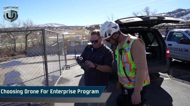
Ever feel overwhelmed when choosing a drone for your enterprise program? If you’re building or scaling your team, you’re probably wondering which platform will really deliver what you need.
That’s the problem many enterprise leaders in utilities, construction, and public safety are facing today. The drone market is crowded, regulations are changing, and every wrong turn can cost time and money.
Choose the right drone and you’ll get accurate data, stay compliant, and prove ROI to stakeholders. Choose the wrong one and you’ll get grounded flights, unusable data, or even be disqualified from federal projects under NDAA restrictions.
This guide will help you avoid that. We’ll break down the main categories of enterprise drones, explain the use cases, and what matters most in 2025 to make an informed decision.
Let’s start by understanding why it matters.
Enterprise drone programs differ from recreational flying or small commercial operations. Here’s why selecting the right one matters.
Enterprise drone programs are different from recreational flying or small commercial operations. In this case, drones are business-critical.
They capture accurate data, streamline workflows, and help organizations comply with strict regulations. Choosing the wrong platform will stall adoption, drain budgets, or even disqualify you from government contracts.
The FAA’s Remote ID rule has changed how drones must be identified in flight, while NDAA restrictions continue to limit the use of Chinese-manufactured drones like DJI in sensitive programs. Meanwhile, UTM integration and BVLOS waivers are redefining what a future-ready enterprise program looks like.
Choosing the right drone isn’t just about specs or camera quality. It’s about having a reliable, scalable, and compliant system.
A well-chosen platform reduces risk while improving efficiency, often offsetting higher upfront costs with long-term savings on operations, labor, and compliance.
Modular payloads and upgrade paths also future-proof your investment, extending the value of each aircraft as missions evolve.
The best place to start with drone selection is the mission itself. Every enterprise drone falls into a specific category based on the type of data it captures – whether that’s high-res mapping for construction, thermal inspection for utilities, LiDAR for forestry, cargo delivery for logistics, or surveillance for security teams. Matching the mission to the right platform is the foundation of choosing a drone for your enterprise program. It’s how you maximize ROI and avoid costly mismatches.
Need to create accurate maps, 3D models, or surveys of large areas? That’s where mapping drones come in. They capture the world from above, delivering orthomosaics, 3D models, and terrain data.
These drones are widely used in construction, road projects, accident reconstruction, and land surveying.
Mapping drones rely on RTK or PPK workflows to achieve survey-grade accuracy, making them essential for geospatial professionals.
The FreeFly Astro series is a US-made NDAA-compliant platform for high-accuracy mapping and surveying. Both models have RTK positioning, hot swappable batteries, and modular payload support. These features make the FreeFly Astro Prime / Max a professional photogrammetry tool.
For standard mapping workflows, the Astro Prime delivers precise results for construction, land survey, and utility inspections. The Astro Max is an upgraded version with more payload capacity and longer flight time, so it’s better suited for large-scale or heavy lift survey missions.
In addition to mapping, the Astro also supports high-end cinematography. It captures cinema-grade video and delivers survey-grade data so you can manage creative and technical deliverables with one drone instead of two. That’s why Astro is a practical choice for enterprise programs.
| Feature | Astro Prime | Astro Max |
| Compliance | NDAA-compliant, U.S.-made | NDAA-compliant, U.S.-made |
| Payload capacity | Up to 1.5 kg (3.3 lbs) | Up to 3 kg (6.6 lbs) |
| Mapping Accuracy | Sub-centimeter with RTK | Sub-centimeter with RTK |
| Flight Time | Up to 37 minutes without payload; 28–34 minutes with LR1 payload | Up to 39 minutes without payload; ~28 minutes with LR1 payload |
| Transmission Range | Up to 10 km | Up to 10 km |
| Obstacle Avoidance | Integrated | Integrated |
| Weight | ~3.5 kg | ~4.5 kg |
| Folded Dimensions | 16″ x 16″ x 6″ | Not Specified |
| Payload Options | Sony ILX-LR1 (61 MP) | Sony ILX-LR1 (61 MP), LiDAR, multispectral, thermal |
| Operating Temp. | -20°C to 50°C | -20°C to 50°C |
The DJI Matrice 4 Enterprise is a flexible and powerful option for large-scale mapping and inspection operations. It combines long flight times with strong photogrammetry performance and versatile payload support.
It’s a great fit for private-sector projects that demand accuracy and efficiency, but NDAA restrictions limit its use in federal contracts.
| Features | Details |
| Payload Support | Multiple enterprise cameras/sensors |
| Mapping Accuracy | High-precision with RTK |
| Max Flight Time | Up to 46-49 minutes |
| Transmission Range | Up to 25 km (FCC) |
| Obstacle Avoidance | Omnidirectional with 3D infrared bottom sensor |
| Weight | 6–7 kg (depending on payload) |
While mapping looks down at the big picture, inspections flip the perspective by focusing on assets above and around us. We’ll explore this in the next section.
When you need to look up instead of down, inspection drones are the tool. Operators use these drones to inspect bridges, powerlines, wind turbines, or cell towers. They’re designed to fly in confined or hazardous spaces.
Inspection drones come with zoom cameras, thermal sensors, and advanced obstacle avoidance. Pilots can safely examine structures from multiple angles, even in complex or GPS-denied environments.
The Skydio X10 is a US-made, NDAA-compliant inspection drone powered by AI autonomy. It’s for bridge, utility, and infrastructure inspections where navigating complex structures safely is key.
Payload options include high-resolution thermal and zoom sensors, so operators can get the detail they need without manual climbs.
| Features | Details |
| NDAA compliance | Yes |
| Max flight time | Up to 40 min |
| Protection rating | IP55 |
| Transmission range (max)* | Up to 12 km (rural LOS); 5G option |
| Obstacle sensing | 360° vision + AI autonomy |
| Weight | 2.11 Kg |
| RTK support | Optional RTK/PPK attachment |
| Typical payloads | VT300-Z: 64MP narrow, 48MP telephoto, FLIR Boson+ thermal; VT300-L: 50MP wide, 64MP narrow, FLIR Boson+ thermal |
The DJI Matrice 300 and 350 RTK are versatile enterprise drones designed for inspection and utility work. Both platforms support zoom, thermal, and LiDAR payloads.
The Matrice 350 RTK is an updated version of the DJI Matrice 300, offering enhanced weather protection, improved transmission, and safety features. While neither is NDAA-compliant, both remain popular in the private sector for their reliability and broad sensor ecosystem.
| Feature | Matrice 300 RTK | Matrice 350 RTK |
| NDAA Compliance | No | No |
| Max Flight Time | Up to 55 minutes | Up to 55 minutes |
| Protection Rating | IP45 | IP55 |
| Transmission Range | Up to 15 km | Up to 20 km |
| Obstacle Sensing | 6-direction sensing/positioning | 6-direction sensing/positioning |
| Payload Options | Zoom, Thermal, LiDAR (H20/H20T, P1, L1) | Zoom, Thermal, LiDAR (H20/H20T, P1, L1) Fully backward-compatible |
| Weight | 3.6 Kg | 3.77 Kg |
Inspection drones streamline workflows and reduce risk by replacing manual climbs, lifts, and scaffolding. They provide fast, detailed visual and thermal data, making inspections safer and more efficient.
But when the inspection goes over miles or mapping requires scale, fixed-wing drones are the way to go.
When the project needs to cover large areas, long corridors, powerlines, railroads, or highways, fixed-wing drones are the best option. They have longer flight times, higher efficiency, and greater range than multirotor platforms.
Fixed-wing drones use an airplane design to fly longer, cover more ground, and deliver survey-grade data in fewer flights. This makes them ideal for industries like transportation, utilities, and agriculture.
The WingtraOne GEN II is a fixed-wing VTOL drone built for corridor and large-area mapping. It combines the efficiency of fixed-wing flight with the flexibility of vertical takeoff and landing (VTOL), allowing operators to cover more ground per mission. With survey-grade payloads and extended endurance, it captures large, accurate datasets efficiently.
Enterprises handling geospatial projects often choose fixed-wing drones as a natural fit. It offers the endurance and coverage needed to map corridors and vast territories such as railways, highways, and mining sites.
| Features | Details |
| Coverage | Up to 460 hectares per flight |
| Mapping Accuracy | Down to 1 cm with PPK/RTK |
| Max Flight Time | Up to 59 minutes |
| Transmission Range | ~10 km |
| Payload Support | Survey-grade RGB & multispectral |
| Weight | ~4.5 kg |
The Trinity F90+ is a German-made fixed-wing drone known for its endurance. It flies up to 90 minutes per mission, covering wide areas for large utility and transportation projects. Its long-range capability reduces the number of flights needed, cutting costs and improving efficiency.
| Features | Details |
| Mapping Accuracy | Down to 1–2 cm with PPK/RTK |
| Flight Time | Up to 90 minutes |
| Transmission Range | Up to 7.5 km (standard), extended options |
| Payload Support | RGB, multispectral, LiDAR |
| Weight | ~5 kg (with payload) |
| Camera Resolution | Up to 42 MP (Sony RX1R II option) |
| Takeoff/Landing | VTOL (vertical takeoff and landing) |
| Max Coverage | ~700 hectares (per flight, at 120 m AGL) |
| Best For | Utilities, transportation corridors, and large-area mapping |
Censys builds U.S.-made, NDAA-compliant VTOL drones designed for public-sector and federal use. They support EO/IR and LiDAR payloads, pairing flexible vertical takeoff with the long range of fixed-wing flight. This makes them a reliable fit for missions that require secure, compliant platforms without compromising on performance.
| Features | Details |
| Mapping Accuracy | Survey-grade accuracy with RTK/PPK support (centimeter-level, depending on payload and conditions) |
| Flight Time | Up to 60 minutes (depending on payload) |
| Transmission Range | Up to 20 km |
| Payload Support | EO/IR, LiDAR, custom integrations |
| Weight | ~6–7 kg (with payload) |
| Camera Resolution | EO up to 20 MP, thermal up to 640p |
| Takeoff/Landing | VTOL (vertical takeoff and landing) |
| Best For | Federal programs, public-sector mapping, secure operations |
For enterprises handling large-scale geospatial projects, fixed-wing drones offer the endurance and coverage required to complete the job effectively.
Every enterprise has different needs, whether it’s mapping, inspection, or creative media. Here’s a side-by-side comparison showing how the leading drones stack up, so you can quickly see which platform best matches your program’s goals.
| Drone Model | Type / Use Case | Flight Time | Camera / Payload Options | NDAA Compliant | Best For | Price |
| FreeFly Astro | Mapping + Cinematography | 39 minutes | 61MP photogrammetry, 4K60 10-bit video | Yes | Mixed-use: survey, mapping + media capture | $ 26,000 |
| DJI Matrice 4 Enterprise | Mapping + Inspection | 46–49 min | Multiple enterprise cameras/sensors | Uses NDAA-compliant components but restricted for federal contracts. | Enterprise mapping & inspections, thermal (4T) | $ 5,928 |
| Skydio X10 | Infrastructure Inspection | 35–40 minutes | 640×512 thermal, zoom, AI autonomy | Yes | Bridge, powerline, confined space inspections | $17,791.99 |
| DJI Matrice 350 RTK | Mapping + Inspection | 55 minutes | 20MP camera, thermal, zoom, lidar pods | No | Enterprise inspection (non-federal programs) | $11,158 |
| WingtraOne GEN II | Fixed-Wing Mapping | 59 minutes | 42MP camera, multispectral, PPK/RTK | No (Swiss) | Corridor mapping, large-area land surveys | $19,900 |
| Quantum Trinity F90+ | Fixed-Wing Mapping | 90 minutes | High-res + multispectral payloads | No (German) | Rail, roads, utilities, and endurance mapping | $24,750 |
| Censys Sentaero VTOL | Fixed-Wing Mapping | 60-80 minutes | EO/IR, multispectral, LiDAR options | NDAA-compliant, approved for federal/public programs | Utilities, energy corridor, U.S. federal work | Not listed |
When building an enterprise drone program, the drone must match your missions, compliance needs, and growth plans. Here are the key things to look for:
Of course, choosing the right drone isn’t about features. Regulations dictate what and where you can actually fly.
It’s not just about flight performance and payload. The value of an enterprise drone program is in how well it collects, processes, and secures data.
Modern programs rely on integration with GIS, CAD, BIM, or inspection software. Look for platforms that offer automated data uploads, cloud storage, and APIs for seamless integration with your existing workflows.
Data security is just as important. Many public sector and utility projects require U.S. data storage to prevent sensitive information from being sent outside the country.
A platform that offers encrypted transmission, secure storage, and role-based access helps enterprises protect their geospatial and inspection data while meeting contract requirements.
When choosing a drone for your enterprise program in 2025, compliance is just as important as performance. Regulations determine what drones you can fly and whether your program can scale.
To stay ahead, pilots and organizations need to understand three major factors:
In short, compliance is about ensuring your drone program stays eligible, scalable, and future-ready.
Enterprise drones aren’t one-size-fits-all. The right choice depends on your mission, whether it’s mapping, inspections, corridor projects, or creative media.
In 2025, compliance adds another layer. Remote ID is mandatory for almost all operations, and NDAA rules determine eligibility for government contracts.
To scale with confidence and avoid costly setbacks, match your platform to both your deliverables and regulatory needs.
Here’s your next step: review your current drone operations, identify compliance gaps, assess your deliverables, and align your fleet with the right platforms.
If you’re still unsure how to move forward, join DroneU for expert guidance and a clear path to scale your enterprise program.

