Opportunity Beckons For Drone Mappers in The Wake of The Coronavirus
As real estate agents clamor to get buyers in homes, they’re chasing 3D models at record speed
- Due to the coronavirus, real estate agents are now wanting to show houses in virtual reality. Realtors are panicking and looking to learn Matterport or hire contractors.
- Drone pilots trained in drone mapping offer a unique advantage over contractors who traditionally offer 3D modeling for real estate.
- Traditionally, Matterport contractors who create 3D models for realtors only create interior models… leaving the door wide open for those who know how to create exterior 3D models.
- Drone pilots who understand close proximity flights gain further market share with the ability to acquire imagery needed to create 3D models in complex environments.
- Drone mappers offer a profitable option without georeferencing
The PROBLEM – How the Virus Outbreak Is Making Real Estate Marketing Impossible
Real Estate agents face a large and ever-growing problem throughout the industry. In the wake of the coronavirus, buyers simply are not attending showings. Even sellers don’t want potential buyers rummaging through their homes and potentially infecting the family. Realtors face a rapidly growing problem when buyers don’t want to travel and sellers don’t want to see the buyers.
Leveraging Virtual Reality Can Help Us Address This Issue
Realtors have been asking, how can we show houses in virtual reality? Buyers can experience the interior of the home through VR goggles or by simply exploring the 3D space through the Zillow app. Real estate agents allow buyers to control the experience but have become quickly asking the photogrammetry community, how can we create exterior models?
Traditionally speaking, most realtors have trusted services like Matterport or service providers to scan homes and create 3D dollhouses using Matterport. Typically, the service providers have offered 360 photos on the exterior of the home to augment the lack of exterior environment or exterior model. Matterport software is by far the most trusted 3D modeling service to produce beautiful life-like models of houses that buyers can experience right from their iPhones.
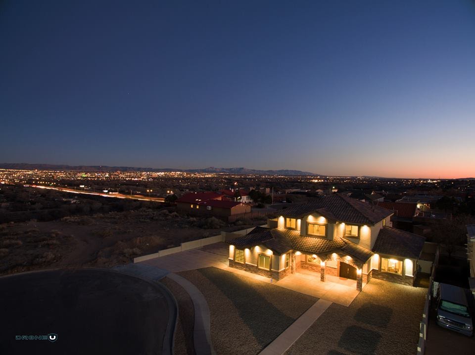
Curb appeal simply hasn’t been perceivable by buyers viewing these Matterport 3D models. Until now. Using drone mapping and a process called photogrammetry we can build life-like 3D Models of the exterior of houses.
Using photogrammetry software like Pix4D or Drone Deploy, drone mapping has never been more convenient and affordable. By setting the starting view of the 3D Model in Sketchfab, we can showcase curb appeal in the most appealing angle possible! Even Insurance adjusters have also been known to hire drone pilots to help inspect and map in the wake of the virus!
Drone pilots who have been trained in using drones to create 2D maps and life-like 3D models have a unique advantage to earn revenue in the wake of the coronavirus. Drone Mappers can easily map houses to create exterior 3D models to merge with interior 3D models to offer realtors a VR experience like never before.
Whether the buyer’s experience takes them directly from Zillow to Matterport, or they view the models on a VR headset – anyway they can experience homes inside and out! As they say, location… location… location…
Now buyers can experience curb appeal, the landscaping, and the location.
Pilots need to remember that convenience is king! Make delivery easy to realtors but make the models easy to navigate for buyers! This is why we have been recently training pilots to merge their drone maps with 3D models from Matterport. Buyers can now experience the exterior of the building, click an annotation link and move right inside to showcase a famous actor’s once adored art studio.
More good news for drone mappers! Since realtors are looking for life-like 3D modeling, georeferencing or the need for GCPs….is well, not needed. 3D Modeling is more focused on visual appeal rather than absolute accuracy. If drone pilots won’t need GCP’s, this will keep their operating costs quite low and increase profits.
The only issue is that most drone pilots aren’t familiar with creating interior 3D models using Matterport.
How Using 360 Degree Cameras With Matterport Results in an Efficient and Compressed Workflow
Thanks to Insta360 working with Matterport, creating 3D models has never been cheaper, easier or even more efficient. After modeling a few homes with the Insta360 One X, I realized that using this 360 camera was so much better than the full-size Matterport option….Why? Well, remember, most people are looking at the models on their phones. Hyper resolution cameras really don’t matter that much…yet. The Matterport version of the hardware has to physically spin during each scan taking approximately a minute or two between scans moving the heavy object around.
When using the Insta360 One X camera, we can easily and quickly move from scan to scan making interior acquisition almost 4x faster than using the traditional Matterport camera. Drone pilots are used to creating efficient complex systems to get more for their money. Interior mapping should be no different.
We recently released all this information to our members through our community to give them a head start to the opportunities. Don’t forget, drone video has always been low hanging fruit for real estate agents. Primed to use drones, this new technical deliverable offers a higher barrier to entry for sophisticated drone pilots.
How Can You Learn To Use 360 Degree Cameras and Matterport?
Well here is the last morsel of good news for trained drone mappers, the learning curve to learn photogrammetry inside is about 1/1000th the size of learning how to map with drones. The cards are stacked quite high for drone mappers right now as learning to use 360 cameras and Matterport is a cakewalk compared to learning the nuanced systems of drone mapping
Drone U plans to have a webinar soon to highlight the potential opportunities they can take advantage of without getting into too much detail. Check out the free webinar.
We will be teaching a live, telecast online class to go over the process of creating interior and exterior 3D models that are easily accessible for buyers. Join me to start taking advantage of this unusual time in history.
Become a Drone U Member.
Do not forget to subscribe and listen to Ask Drone U, the #1 drone podcast on iTunes!
Using Drone Sprayers to Fight the Coronavirus – All You Need To Know
The speed with which the coronavirus has spread across the world is certainly shocking. At the time of publishing this article, total number of worldwide deaths due to Covid-19 stood at 82,000. United States is particularly badly hit. In the United States alone, this virus has infected more than 400,000 people and caused more than 12,000 deaths.
While scientists and researchers across the world are sparing no efforts to find a vaccine that can cure this deadly virus, this could take time. Meanwhile, we need to leverage technology and creativity to come up with effective ways to contain this virus.
Using drone sprayers is one such possibility. Using drone sprayers, we can treat high-risk zones with heavy footfall while greatly limiting human to human contact. Drone sprayers can be particularly useful when the lockdown is lifted and offices, schools and colleges resume.
How Countries Across the World are Using Drone Sprayers to Contain the Coronavirus
China is at the forefront when it comes to using drone spraying for disinfection. Chinese companies, DJI and XAG have disinfected more than 1500 million square meters using drone sprayers. Countries like Italy, Spain, Indonesia, Philippines and India are also putting this technology to good use.
Health-workers in Philippines used a modified DJI Agras MG-1P, an octocopter drone with a 10-liter payload for disinfecting streets and buildings. In India, plans are afoot to use fuel-powered drones that can cover 3 lakh square meters and dispense 900 liters of disinfectant in a single day.
Are Drone Sprayers More Efficient Than Traditional Spraying Methods?
Use of manned aircraft for might be possible for crop dusting in wide, open fields. But, when it comes to commercial and residential zones, traditionally disinfectant spraying can be done using ground-based rigs or backpack sprayers.
According to Chinese Investment Connections Director Robert Pearson, who has been working with Chinese company XAG, “A drone can spray 600,000 square meter a day – that’s the equivalent of 100 workers”
Robert Pearson, Chinese Investment Connections Director
Additionally, sending human personnel with backpack sprayers in infected zones is fraught with risk. And ground-based sprayers cannot access hard to reach areas and indoor spaces. Considering the above, drone spraying is surely an option worth exploring.
Which are the Most Effective Disinfectants?
Typically, a chlorine or ethyl alcohol-based disinfectant is used to treat infected surfaces. United States Environmental Protection Agency has published a list of disinfectants that are proven to be effective against SARS-CoV-2, the virus that causes COVID-19. You can access this list here.
As far as drone spraying is concerned, the use of highly concentrated disinfectant is recommended. Once ejected from the nozzle, air moisture will dilute the disinfectant before it settles down on the surface resulting in more effective disinfection.
Can You Use Ultraviolet Germicidal Irradiation (UVGI) to Treat Infected Surfaces?
Ultraviolet Germicidal Irradiation involves the use of UV-C light to treat infected surfaces. And with an ability to destroy 99.99% of bacteria, this technology is incredibly effective. However, mounting a UV-C light on a drone poses several practical challenges.
The first challenge is the heavy payload. Digital Aerolus, an autonomous technology provider is trying to develop lightweight UV-C lights which can be mounted on drones. The second and perhaps a bigger challenge is that exposure to UV-C can cause skin cancer and irreparable damage to the human eye. Because of this, use of drones mounted with UV-C lights can be dangerous, especially in public places. Scientists have proposed the use of FAR-UVC light, another kind of ultraviolet light that is not harmful to human beings. However, this technology is still in research phase and has not been deployed on field.
Do You Need Special Licensing for Drone Spraying in the United States?
Yes, you do. Apart from a Part 137 certificate, you will also need a Part 107 waiver. Additionally, you might also need to procure permission from your state officials. If you wish to learn more about this topic, check out our interview with Philip Shaner from PnC Max Enterprises. Philip’s company has years of experience serving farms and ranches with agriculture drones.
Become a Drone U Member.
Do not forget to subscribe and listen to Ask Drone U, the #1 drone podcast on iTunes!
DJI Mavic Mini versus DJI Spark versus DJI Mavic Air – Which Entry Level Drone Should You Buy?
DJI made a huge splash when they launched their latest drone, the DJI Mavic Mini back in November 2019. Priced at $399, its biggest selling point is its palm-sized dimensions.
The Mavic Mini is certainly an engineering marvel and is touted as a good option for weekend flyers who are looking to capture some memorable family moments. But is the Mavic Mini a good option for Part 107 commercial pilots? And, how does the DJI Mavic Mini compare to their other entry-level product, DJI Spark? And should you rather buy the more capable but expensive, DJI Mavic Air?
So, let’s take it from the top.
Build
The biggest USP of the DJI Mavic Mini is its portability and its 249 grams weight. Both the Mavic Air (430 grams) and the DJI Spark (300 grams) weigh more than the DJI Mavic Mini. And while the Mavic Mini and Mavic Air are portable, the DJI Spark is not. No bigger than a large smartphone, the DJI Mavic Mini can easily fit into your pocket.
License and Registration
As per the drone laws in the United States, any drone weighing less than 250 grams need not be registered with the FAA. However, doing away with FAA registration requirements is not a huge advantage. Online drone registration is quick and easy and just costs $5.
As far as drone registration goes, it is important to remember that if you attach a customized kit or props guards to your DJI Mavic Mini, this will push up your drone weight to more than 250 grams. And you WILL have to register your drone.
Additionally, countries like Canada have drone laws that are extremely favorable for sub-250 gram drones like the DJI Mavic Mini. Locals and US citizens can fly the DJI Mavic Mini and capture the beautiful Canadian landscape without any license or registration. Check out our Drone Laws in Canada guide to learn more.
Camera
None of these drones have 4K60 capabilities. And no, you can’t shoot 4K60 with DJI’s flagship drone, the Mavic 2 Pro either. If you need 4K60 capabilities, you will have to opt for the Phantom 4 Pro V2.
DJI Mavic Air has a maximum resolution of 4K30 whereas DJI Mavic Mini has a maximum resolution of 2.7K30. The DJI Spark has a maximum resolution of 1080p. The DJI Mavic Mini is a great choice for beginner drone pilots who are looking for a portable and affordable solution.
Flight Time
At 2600 mAh, DJI Mavic Mini has the largest drone battery and the longest flight time of 30 minutes. Of course, the stripped-down build helps eke out some extra flying minutes. DJI Mavic Air’s 2375 mAh battery will keep it up in the air for 21 minutes. DJI Spark has the smallest battery size of 1480 mAh and a flight time of just 16 minutes.
Flight Control
DJI Mavic Mini uses a more basic and stripped-down app, DJI Fly for flight control. Though this app works quite well, the DJI Go4 App used to fly the DJI Spark and DJI Mavic Air which allows you access to more settings and more control over flight.
The much-loved ActiveTrak feature which allows you to follow an object is missing in the DJI Fly App. You can still follow a subject using one of the Quickshot modes but ActiveTrak is far more capable.
We were disappointed that we were unable to view battery voltage on the Mavic Mini screen. Additionally, we were slightly unnerved by the absence of a physical flight mode switch. If you wish to switch flight modes, you will have to do so in the app itself.
The Mavic Mini has no sensing technology to detect and avoid obstacles.
Because of this, it is extremely difficult to fly the Mini in small, confined spaces.
Pro Hack – You can turn off downward obstacle avoidance on the DJI Mavic Mini by putting tape on the sensor
Pricing and Availability
At $399, the DJI Mavic Mini is your cheapest option. The DJI Spark is not available on the online store anymore. But you can buy one in a clearance sale by going here. At $919, the DJI Mavic Air is the most expensive of the lot. As per industry rumors, DJI is planning on releasing a new DJI Mavic or DJI Mavic Air 2 with a powerful Ambarella sensor in summer 2020. You can read all about it by going here. The ongoing virus outbreak might push back the release date of this new DJI drone to the end of the year.
Conclusion
At $399, the DJI Mavic Mini is a great option for recreational/weekend flyers. However owing to a) Lack of Obstacle Avoidance and b) Inability to monitor battery voltage, inexperienced pilots need to be extra careful or they might end up crashing their drone. Whereas, the DJI Mavic Air is a good entry-level, sub-$1,000 option for folks looking to buy a drone with 4K capabilities. You can check out our detailed DJI Mavic Air review here:
Drone Laws In Canada
Information and Resources for Flying Drones in Canada
According to Transport Canada Civil Aviation (TCCA), flying drones is legal in Canada. But, there are various nuances to be aware of before you set flight in this beautiful country.
Are drone laws in Canada more lenient compared to the United States? Can you really fly your drone over people? And are Part 107 pilots legally allowed to fly drones in Canada?
We answer these and many more question in this comprehensive guide. So, let’s start with the basics.
Yes. You need a drone license to fly a drone in Canada. There are two kinds of drone licenses: Basic and Advanced.
You must be at least 14 years old to take the basic exam. To get your Basic drone license or certificate:
1. Complete an Online Exam: The Basic exam consists of 35 multiple choice questions. You have 90 minutes to complete the exam. You need to answer 23 questions correctly to pass this exam.
You must be at least 16 years old to take the Advanced exam. To get your Advanced drone license or Certificate:
1. Complete an Online Exam: The Advanced exam consists of 50 multiple choice questions. You will get 60 minutes to complete this exam. You need to answer 40 or more questions correctly to pass this exam.
2. Complete a Flight Review: A flight reviewer who is associated with a drone school will assess your ability to safely fly your drone. If you clear your test, you will receive an email confirmation within 24 hours. However, if you fail, you can retake the test. There are no limits on the number of times you can take the test.
You will need an Advanced Certificate if you wish to fly in controlled/restricted airspace or over people. Restricted airspace can be either permanent or temporary. You will encounter permanent restrictions over the PM’s house in Ottawa, Ontario for instance. Whereas, you might find a temporary restriction around a forest fire.
• Maintain Visual Line of Sight
• Fly Below 400 Feet
• Maintain a Minimum Horizontal Distance of 30 metres or roughly 100 feet from people if you have a basic certificate
• Away from emergency operations and advertised events
• Avoid forest fires, outdoor concerts and parades
• You need an advanced certificate to fly in controlled airspace or over people
You will need an advanced certificate to fly your drone over people in Canada. Additionally, you will need a drone that is eligible to fly advanced operations. You can check out the entire list of eligible drones by going here.
So, if you retrofit your DJI Mavic or Phantom with a Parazero or Indemnis parachute safety system, you can very well fly your drone over people. As per Canadian drone laws, you can fly within 5 meters or 16.4 feet of any person associated with the operation.
Yes. It is. Drone Delivery Canada Corp. managed to procure a SFOC which enables them to make drone deliveries across Canada. One of Drone Delivery Canada Corp.’s larger drone, the Robin XL can carry payloads of 25 pounds and can fly a maximum distance of 60 km. Drone deliveries with the Robin XL are expected to commence by Q2 2020.
Canada has different sets of privacy guidelines for hobby and commercial pilots. These are some important privacy guidelines for hobby or recreational pilots flying a drone in Canada:
· You are responsible for all personal information collected by your drone
· Avoid capturing personal information. So blur out faces and license plates, for example
· Obtain consent in case you have captured any personal information
You can check out the entire list of instructions here.
Commercial drone pilots flying in Canada must follow the Personal Information Protection and Electronic Documents Act (PIPEDA). However, Alberta, British Columbia or Quebec have their own set of privacy laws that drone pilots will have to abide to.
Yes. Absolutely.
As per the Transport Canada Website, if “you are not a Canadian citizen, permanent resident of Canada or a corporation incorporated by or under the laws of Canada or a province”, you can fly a drone weighing more than 250 grams in Canada by procuring a SFOC or Special Flight Operations Certificate.
On recent ADU show, Justin Miller, Technical Team Lead, Transport Canada revealed that having a Part 107 certificate can possibly increase your chances of getting a SFOC. Canada does not differentiate between commercial and hobby pilots. So, you will need a SFOC even if you are a casual flyer planning on capturing the beautiful Canadian landscape.
Part 107 pilots do NOT need a SFOC to fly a drone weighing less than 250 grams in uncontrolled airspace Canada. So, certainly, there is considerable value in owning a DJI Mavic Mini which is classified as a “micro-drone” as per Canadian drone laws.
Contrary to popular perception, Part 107 pilots CANNOT fly a drone weighing more than 250 grams without a SFOC under a Canadian drone pilot’s supervision.
The Canadian Police is in charge of enforcement, and they may ask you to furnish your SFOC. If you fail to comply, you may be slapped with fines ranging from $3,000 to $5,000.
1. Complete the SFOC Application HERE.
2. Send the form and documents to: Remotely Piloted Aircraft Systems Centre of Expertise, 700, Leigh-Capreol Place Dorval, Quebec H4Y 1G7 OR via EMAIL
An SFOC is not a generic document but one that is customized to the applicant’s needs.
Become a Drone U Member.
Do not forget to subscribe and listen to Ask Drone U, the #1 drone podcast on iTunes!
What if Drones could Help Stop the Coronavirus?
As the corona virus grows to pandemic levels in over 37 countries, drones could massively increase an effective response as we can use it for food delivery, testing, and vaccine delivery.
Quarantine is Necessary for Effective Pandemic Response
The corona virus is already having a palpable effect on the world economy. As quarantine efforts increase globally, the creative solutions necessary to scale these efforts are becoming more viable by the minute. As the number of infectious patients increases, how can we increase the efficiency of our countermeasures against the virus? We have already seen drones make an effective effort in reducing the spread of the virus. Drones are spraying areas with disinfectant and already delivering food to communities in Asia.
It’s easy to understand the solutions necessary to stop the coronavirus. Quarantine measures, in order to work, must truly lock off the patient from the rest of the world without any human contact. Even doctors are fully suiting up with respirators and full body suits. This added time is going to increase the overall time to react to patients and even test new ones. How can we effectively test millions of potential super spreaders? How can we deliver test kits to unique homes and inhibit human to human exposure from the virus?
Patients Can Receive Coronavirus Test Kits & Supplies With Drone Deliveries
In a recent study, it was found that drone delivery could provide increased access to consumers in Europe. Noting that 40 million Europeans would be able to take advantage of drone delivery under current constraints.
What if those 40 million people could receive coronavirus test kits? How much time would we save with this method over the traditional means? By eliminating the need for a human to deliver the test kit, we also vastly reduce the propensity for community spreading of the virus. While reducing human contact is important, reaching vast patients in a minimum-amount-of-time, could vastly increase the propensity of eliminating the spread of the virus. How many lives would we save? How many lives would it take to make drone delivery a reality?
Many Americans and Europeans are likely afraid to be tested for the coronavirus, due to the fears of stigma from the quarantine. We can effectively reduce that stigma by using drones to deliver food, medicine and vaccines to homes…instead of sending doctors and potentially increasing the transmission of the virus.
How Existing Legislature is Preventing Drone Delivery From Taking Off
Under the current FAA regulations of Part 107, drone delivery isn’t viable. This pushed Amazon, Google Wing and others to pursue aircraft certification through Part 135, the air-carrier rules. If the current rules for Remote ID were implemented, the propensity for success with this plan would be highly reduced, if outright impossible. We’re excited that the FAA is starting to address the two parallel methods of getting drones air worthy. Yet with the proposed remote Id rules, we see many barriers to entry that would further inhibit these operations. Without going into a 20 page article to explain these arguments, make sure to check out our many podcasts and information on the Remote ID NPRM.
Become a Drone U Member.
Do not forget to subscribe and Listen to Ask Drone U, the #1 drone podcast
Autel Evo 2 DELAYED Due to Production Glitches
Autel Pushes Back Release Date for the Autel Evo 2 Leaving the Door Open for DJI
Regular ADU listeners might remember that we flew the Autel Evo 2 at CES 2020. We were blown away by this drone’s specs and capabilities, and even published a comprehensive review on the site.
We had informed readers that Autel Robotics was planning on launching the EVO II (8K) in January. And the 6K and dual variants were to be launched soon after.
However, Autel EVO II has run into some production glitches and the release date for this much-anticipated drone has been pushed back to March. This is an update that was posted on Autel’s Facebook page:
Autel Evo 2 Release Date Pushed Back to March 2020
Autel’s Facebook Post
Hello Everyone!
First, we want to thank all of our fans and followers. It doesn’t matter if you just follow one of our social channels, or if you fly our products every day. Your support and enthusiasm have always kept us going here at the Seattle officeWith the announcement of EVO II at CES, the response has been absolutely crazy. This community is exploding, and we thank you for your patience with us as we are still trying to catch up on responses.
We also want to be as transparent as possible and give you all periodic updates on the status and availability of EVO II. That way you have the most up to date information straight from us and not just rumors.
Our goal at CES was to get the initial units of EVO II (8k) into the hands of dealers by the end of January. Unfortunately, during production, we found a bug in our software that could limit flight performance under normal operation. Instead of shipping the hardware with a known issue and forcing users to perform day 1 updates, we have decided to delay the rest of production and shipments until we have resolved the issue. Our projected timeline is to have EVO II available for purchase in March. This is not a set date or time frame, and things can always change. But with the information we have today, that is our goal.
The team in Seattle is very small and we are adding channel support as we can. We are looking to start up our website newsletter again in the next few weeks. So for any future updates, please check our website, the official social channels, and emails coming directly from us.
We thank you for your patience. If you have any questions please do not hesitate to get a hold of us at [email protected]
Thank you all again and fly safe!
Will DJI Mavic 3 Hit the Markets Before Autel Evo 2?
Just yesterday, we had reported that DJI had pushed back the release date for the DJI Mavic 3 to summer 2020. As per industry reports, DJI is keen to come out with a drone that will outshine new entrants like the Skydio 2 and the Autel Evo 2 in terms of specs and capabilities.
To outdo the competition, DJI might equip their new drones with powerful Ambarella sensors. To learn more about this and how it will affect the drone’s performance, check out our Mavic 2 Air blog post now.
Having said that, both Autel and DJI will be scrambling to gain the crucial first mover advantage.
We shall be the first to update this space as soon as we receive more updates!
Remote ID NPRM – Why FAA’s Proposal to Use Session ID’s is a Flawed One
How the Use of Session ID’s will Result in Compliance & Implementation Issues, Increase Costs, and Raise Privacy Concerns
The NPRM released by the FAA has caused quite a stir in the UAS community as everyone from hobbyists to manufacturers scrutinize to find problems with the proposed rule. The document feels very chopped up, not concise, and just throws so much information at you that it’s a bit like drinking from a fire hose. I have been asked to look more closely into “Session Identification” or Session IDs and what all surrounds that aspect of the proposed rule. I want to apologize ahead of time for all of the acronyms, but this is the government we are dealing with here.
What is a Session ID?
A session ID is an optional item from the network side of Remote ID and would be assigned by the Remote ID service supplier (USS as the NPRM calls them). It would be a one-time use number for a specific flight, and replace the use of the serial number as the main identifier for the UAS. If the FAA needs to match the flight ID to get the serial number, the USS would have that info to be able to tell the FAA the serial number associated with the session ID. One thing I want to be clear about – the session ID replaces the serial number for BOTH the local broadcast and the network side of Remote ID.
What is the Rationale for Using Session ID’s?
The specific reasoning here the FAA uses for session ID’s is to provide an added layer of privacy. Let’s say the police are using a drone to track someone they are doing surveillance on. If the serial number were always being used, a suspect just needs to figure out the first time what the serial number of the drone is (since it is being broadcast) and would easily be able to see a police drone without looking outside as they could just check the serial numbers of drones in their area. Another scenario could be a business who is trying to track a competitors drones, and could easily do so if the serial number was used over and over again. This is a great move by the FAA but it has a few issues.
What are Some of Major Issues with Using Session ID’s?
Session ID’s Will Not Work When Internet is Unavailable
First, the FAA wants Remote ID to be fool proof, including the internet connection for sending info to USS, but they are not very clear on how the internet connection happens. Is it done via a SIM card inside a drone, or through an internet connection on the control station (cell phone)? What if I have Wi-Fi available on my control station, but I don’t connect it? It is my belief that in the end the FAA wants drones to have a direct internet connection via the cell phone network, but is looking for feedback on potential radio frequency issues. Honestly, there is a lot that needs to be answered in regards to the internet connection. Despite the bad info being spread around, a standard remote ID flight can take place if the internet is “unavailable”, but you would no longer be able to get a session ID for that layer of privacy. The drone would have to default to using its serial number. What if you are an official or company who needs that level of privacy, but you are not in an area where the internet is available? No security for you…
Law Enforcement Officials Will Find it Difficult to Locate Criminal Operators Using Session ID’s
Another issue is the correlation of data between the session ID and the owner of the drone. Those items are in completely separate databases. The FAA holds the phone number and name tied to the serial number of a drone. So a law enforcement officer looking into a drone would have to reach out to the USS in order to tie the session ID to the serial number, then reach out to the FAA to tie the serial number to the owner. Police don’t like to walk into situations blind, and using Remote ID to find the operator location and just walking up seems like it could easily lead to drone owners having guns drawn on them, or police unaware that they are about to encounter hostile criminal operators. That might seem far-fetched, but we have not had this situation take place yet as typically drone operators are hard to find while operating. There needs to be an easier way to manage that data and make it more accessible for officials who need it quickly.
Use of Session ID Could Lead to Higher Costs
The final odd piece to the network side of Remote ID that somewhat ties to the sessions is the concept of the USS. These providers are mostly portrayed in the NPRM as being companies that already offer LAANC (Kittyhawk.io, UASidekick, etc). Due to the complexity of the systems needed to do the network side of Remote ID, I think we can except the costs of a USS to be significantly more than the $5 per month that some LAANC providers charge – something I have all but confirmed in discussions with a current LAANC provider who will likely also be a USS.
And Some Serious Implementation Issues…
The FAA gives also examples of corporations being able to set up and act as their own USS provider for their drones or operations. How will the network information be available to the public or to officials when a private company is holding their own data? As well how would officials know who to call to start associating the session ID to the owner of the drone? Then, will there be standard for how to create a session ID that is similar to the standard ANSI serial number system the FAA wants to put in place?
Conclusion
Hopefully this provides a brief, but informative look into sessions IDs. Sadly, it also raises a lot of unanswered questions. I encourage everyone to make sure to take the time to do your own research on the NPRM by reading more articles or the NPRM itself, then taking the time to leave the FAA some well-informed comments.
~Jonathan Elliot
Owner/Head Pilot, MKE Drones
Become a Drone U Member.
Do not forget to subscribe and Listen to Ask Drone U, the #1 drone podcast
Jonathan Elliot is the Owner/Head Pilot for MKE Drones. MKE Drones is the top aerial service provider in Milwaukee, providing drone photos and video that are done in a safe manner that complies with all FAA commercial drone regulations.
DJI Mavic Air 2 in April 2020 – Are the Rumors True?
Will There Be a DJI Mavic Air 2?
As per the latest industry rumors, the DJI Mavic Air 2 will be released in April 2020.
What are the Rumored Specs of the DJI Mavic Air 2?
Our good friend, the Chinese drone pilot OsitaLV recently released these images from his Twitter account. As per industry rumors, this could possibly be the new DJI Mavic Air 2.
Is that it, just that one? pic.twitter.com/Ap8rrzC71n
— OsitaLV (@OsitaLV) March 10, 2020
From the above images, it is evident that the DJI Mavic Air 2’s design has been inspired from its larger cousin, the DJI Mavic 2 Pro. The controller though, is quite different, design-wise from the original DJI Mavic Air. Unlike the original controller, your smartphone will now be mounted on the top of the controller.
From these leaked images, these are the rumored specs for the DJI Mavic Air 2:
- Better Design
- Longer Battery Life
- Better Quality 4K Video
- ADS-B Receivers
- 360 Degree Obstacle Avoidance
- LED Lights
- Dual Vision System
- Infrared Sensing System
- Bottom Auxillary Light Assists
- Ambarella Processor
We shall be updating this space as soon as we receive more updates.
How a DJI Mavic Air 2 Powered by an Ambarella Processor Could Result in Superior Flight Performance & Footage
Ambarella is a California-based semi-conductor design company that specializes in AI-Vision Processors for cutting edge applications. Apart from drones, Ambarella processors are used to power self-driving cars, security devices, industrial machinery, and robots.
Using an Ambarella processor could potentially result in:
- Enhanced Autonomous Capabilities
- Superior Video Quality
Let us talk about Flight Autonomy first.
Could the Mavic Air 2 Be Equipped with Autonomous Capabilities?
Possibly.
Our technologies make cameras smarter—enabling features like person detection, object classification, analytics, and more—performing complex data analysis in real time, delivering breath-taking imagery, and preserving vital system resources such as power and network bandwidth.
Ambarella Website
In simple words, a DJI Mavic Air equipped with a powerful Ambarella processor shall do a better job of reading the environment which will result in enhanced autonomous capabilities.
At CES 2018, Ambarella demoed a “super drone” featuring a CV1 chip. Like the Skydio 2, this super drone is adept in autonomous navigation, detecting and avoiding obstacles. It remains to be seen whether the competition will force DJI (more on this later) to go all out and equip the DJI Mavic Air 2 with such powerful processors.
Will You Be Able to Grab Superior Footage with the New Mavic Air?
DJI’s flagship drone, the Mavic 2 Pro is an excellent drone with a 10-bit, Hasselblad sensor. But, while you can grab some stunning photographs with this drone, the video quality is lackluster at best.
Our friends at DroneDJ reported that this disappointing video quality could be because of DJI’s decision to replace an Ambarella processor with a non-branded processor. Thankfully, DJI seems to have realized their folly as they have gone back to using the Ambarella processor on the DJI Mavic Mini.
We expect this trend to continue. It is likely that DJI will use an Ambarella processor on the new DJI Mavic Air as well.
Will the Mavic Air 2 Be Significantly Better Compared to Its Predecessor, the DJI Mavic Air?
Absolutely.
As per industry reports, release of the Skydio 2 and the Autel Evo 2 has forced DJI to go back to the drawing board. Particularly, the American-made Skydio 2 which detects and avoids obstacles using both AI and GPS could potentially change the way we fly. We flew the Skydio 2 right after its release and were truly blown away but this drone’s flying capabilities.
It is of little surprise that DJI is leaving no strings unattached when it comes to their 2020 releases – Mavic Air 2, DJI Mavic 3, and DJI Inspire 3.
Having said that, we expect the Mavic Air 2 to be far superior to its predecessor, the DJI Mavic Air.
We highlighted the drawbacks of the DJI Mavic Air when this drone was first released in early 2018. Some of the main drawbacks that we discussed:
- Absence of 4K60
- Poor Battery Life
- Absence of Atti Mode
- Poor Dynamic Range
- Issues with the Camera Gimbal
You can check out our comprehensive review here:
We certainly hope that DJI addresses these problems with the Mavic Air 2. We shall be the first to review this drone when it hits the market. Watch this space for updates!
Become a Drone U Member.
Do not forget to subscribe and listen to Ask Drone U, the #1 drone podcast on iTunes!
State Farm Drone Insurance Policy – Should You Buy It?
If you are shopping around for drone insurance, you must have heard of State Farm Drone Insurance.
So, is it true that State Farm offers the “Most Affordable Drone Insurance”? And, does this policy provide coverage to Part 107 pilots as well?
Read our detailed review where we cover all this and much more in great detail.
Does State Farm have Drone Insurance?
Yes, it does.
State Farm drone insurance has become the go-to option for hobby pilots because of its affordable cost. State Farm offers drone insurance under its “Personal Articles Policy”. This policy covers many personal items – cameras being one of them. Your drone will be insured under this particular sub-category.
To Be Noted – This is a Recreational Drone Insurance that is not meant for Part 107 or commercial drone pilots.
What All is Covered Under State Farm’s “Personal Articles Policy”?
State Farm’s Personal Article Policy will cover:
- Bicycles (such as racing bikes and electronic assist bicycles)
- Cameras
- Collectibles (such as dolls, model trains, sports cards, comic books, and stamp and coin collections)
- Computer equipment and software (personal use only)
- Fine art (such as paintings and sculptures)
- Furs
- Hearing aids and medical devices (such as hearing implants and insulin pumps)
- Jewelry
- Musical instruments
- Prosthetic devices (such as artificial eyes and limbs)
- Silverware/goldware
- Sports equipment
- Sports, leisure, and powersport items (such as fishing equipment, bicycles, and golf clubs)
Why Should You Purchase State Farm Drone Insurance? Here are the Main Benefits…
Cost
Costing barely $6 per month or $60-$70 per year, this is one the most affordable drone insurance for hobby pilots.
Zero Deductible
This is another huge benefit. Insurance companies charge a deductible to cover their administrative costs. But because this policy comes with zero deductible, you can expect full reimbursement if you crash your drone.
Inflation Coverage
If you opt for this additional feature, your drone value will be appraised annually based on the Consumer Product inflation index.
Sounds Too Good To Be True…Any Catches?
This is what I was wondering as well after reading all the positive reviews online. After some research, this is what I found:
You Might NOT Have a Positive Experience When You Renew Your Policy
We found that some pilots were either denied a zero-deductible policy or worse…denied coverage altogether when they attempted to renew their policy. Note that you need to renew your policy every time you crash your drone.
Particularly, some pilots have found it difficult to renew their policy if they crashed their drone within the first year.
Coverage is NOT Available Everywhere
If you a drone pilot in California, you are out of luck. State Farm Drone Insurance is not available in the state of California.
This is NOT a Liability coverage
This policy does not cover any damage to people and property that you might cause with your drone.
You must be following FAA guidelines while flying:
Which means, since the FAA recently changed recreational FAA drone rules, if your house falls in controlled airspace… you must always obtain a LAANC authorization before flying. If you fail to acquire the authorization and you crash, don’t expect your claim to be covered.
How Do I File a Claim?
Filing a State Farm Drone Insurance claim is a simple four-step process:
Step 1: File your claim through the website, app, or by calling 800-SF-CLAIM (800-732-5246)
Step 2: Review. You might be asked to furnish details like date and time of the accident, photos etc.
Step 3: Estimates + Repairs
Step 4: Payments are usually disbursed in 3 days
Any Alternatives to State Farm Drone Insurance?
Geico Drone Insurance is another good option for hobby pilots.
Skywatch is another good option for recreational pilots.
But, I am a Part 107 Pilot. Which is the Best Drone Insurance For Me?
If you are a Part 107 pilot, we strongly recommend you check out Skywatch Drone Insurance. Check out our detailed Drone Insurance Guide for an in-depth cost comparison.
Become a Drone U Member.
Do not forget to subscribe and listen to Ask Drone U, the #1 drone podcast on iTunes!
FAA Announces New Remote ID Technology…Why are We Disappointed?
How FAA’s New Remote ID Proposal Will Endanger the Drone Pilot’s Safety and End Up Hurting the Drone Industry As a Whole
FAA Proposes Remote ID..By Vic Moss
I’m going to start this article with a qualifier: “I am pro UAS Remote ID”.
I was incredibly excited to have the ability to comment on the proposed NPRM, even if it was already 29 months late.
And oh, how I wanted this NPRM to be good. I wanted it to be something the industry can have tweaked and we can get pushed out post haste. I wanted to have the industry fall in line behind this NPRM and tell the FAA, “Let’s get this done and open up the skies!”
It’s not, it won’t be, and we won’t. Period.
As the NPRM is written, the FAA should just shoot this horse before the gate even opens. This race is over before the starter even fires his starting gun. We can’t even get past the first page of the Executive Summary without realizing that a key component to the success of Remote ID ain’t gonna happen.
The NPRM states that full implementation of Remote ID (RID) relies on “three interdependent parts”. First is the proposed rule itself. The second is a network or RID service suppliers (RID USS), similar to how LAANC works today. The third is the “collection of technical requirements that standards-setting organizations will develop to meet the performance-based design and production requirements in this proposed rule”.
They forgot about a fourth interdependent part, and one that is crucial to the success of the Remote Identification system. That fourth (and argumentatively the most important) aspect of RID is compliance. Low compliance, or even less than very high compliance, will destroy the concept and success of Remote ID.
How to Comply with FAA’s New Remote Identification Rule
The summary states there are three methods of being in compliance with RID.
Option 1 states the drone simultaneously transmits ID message via radio frequency (pretty much all ready to fly drones do this already), as well as via internet. The big issue here is that in order to transmit via internet we would require a data plan that would be very expensive for many operators. In addition, we would have to pay a subscription fee to use the Remote ID USS.
This creates additional monetary burdens to businesses, manufacturers, and imposes new burdens on hobbyists. Although it does allow for flight without RID method by using a “session”, as of now, I can’t see a method of maintaining and supplying that session info.
Option 2 allow drones to operate on a “limited remote ID UAS” basis. But that limits to flight to 400’ from operator (FAA uses the term ground station). 400’ is nothing. We can’t do our job if we can’t fly more than 400’. We ruin the operational efficiency that drones provide to other industries. And why 400’? Who came up with that number? Did someone just draw a column with a 400’ ceiling and radius and call it good? That’s a ridiculous limitation. If you have 20/20 vision, with a 400mm cross section, you can essentially see the drone until about 2200-2400 feet away.
Option 3 is for drones without RID equipment within the boundaries of an “FAA-recognized identification area” or (FRIA). While this is certainly a viable option for clubs like AMA fields (and undoubtedly this option’s targeted audience along with FPV racers), it’s completely unworkable for the commercial world, and/or hobbyists wanting to fly around a park or in their neighborhoods.
How FAA’s New Remote ID Proposal Could Seriously Threaten the Drone Pilot’s Safety
So, right off the bat, there are serious problems for many inside the commercial and recreational UAS communities.
The major issue that would create very limited compliance is that options 1 and 2 require “Latitude/longitude and altitude of the control station [operator] and UA” be transmitted at all times, and to the public.
I don’t know about other operators, but I DO NOT want my location transmitted over public airways.
Actually I do know about other operators too, this is not an option for many of us at all. The technical wording is “message”. That the “message” (as written) requires “UAS ID (serial number of UAS or session ID); Latitude/longitude and altitude of the control station; and Time stamp.”
There is no problem with people knowing where my VO and I are flying and for them to see aircraft location. We even wear our orange or green Hi-Vis vests. If there is a problem, I want people to find me and ask questions. These interactions almost always end in education for me, but that’s not always the case in other location. The problem with being able to find my location via an RID system is that people who have no business needing to know where I am will be able to easily find me.
We all know of people who have been threatened, or we have been part of a thread where people threaten to shoot us down. We also know that the majority of the time we’re dealing with those who are just blowing smoke and being keyboard warriors. But we also all know that there are those out there that are just unstable or paranoid enough to have a system that will “sniff” for drones and take action. We see it daily in the drone groups. People fear the unknown.
If we must transmit our location, that information should only be made available to law enforcement. Period.
This sentence, on page 171 of the NPRM, scares the living daylights out of me as well: “Remote ID USS would be required to provide to the public, for no cost, the UAS Identification message element, either the UAS serial number or session ID.” Remember, as currently written, that includes operator location. Which means if you fly some areas at the same time every month, like we do occasionally, if someone doesn’t like the fact that you’re flying over their home every month, they can be waiting for you the next time you’re there. The sentence quoted above in the NPRM is followed by this one: “At this time, the FAA does not intend to make registration data held under 14 CFR part 48 available to Remote ID USS or the general public.”
“At this time” should put a chill down anyone’s spine. “At this time” means it may happen at a different time in the future. And what is part of our registration? Our addresses. Let that sink in.
And This is How Much It Will Cost The Drone Pilot To Access the New Remote ID Infrastructure
Let’s talk cost for a bit.
The FAA estimates that it would cost around $2.50 per month for a RID USS subscription. There will be the additional cost of data plans for Option 1 flights. Remember, unless you do not have internet available (Wi-Fi counts as internet), you must broadcast your “message” in real time during your flight.
So now drone companies paying private contracts to aggregate our data, then resell it. Absolutely not. The Government already made this mistake with Facebook.
That means a data plan. And a healthy one. Someone flying multiple times a week, and/or for hours per day, this would become financially burdensome. Someone flying large tracts for mapping or inspections will be racking up some serious data charges to AT&T, or Verizon, or any number of other carriers. And you’ll need to keep up with the latest technology to stay up to speed with your plan. While unlimited data is always an option, a quick check on my AT&T plan shows that would cost me an additional $60/month.
How Manufactured Perceptions are Hurting the Drone Industry
Where does the justification come from for some of this nonsense? Gatwick. No, really.
Page 197 talks about “Benefit Summary” of the Remote ID system. We can all come up with legitimate justifications for why we need RID in this country. That’s not really all that hard to come up with some benefits and cost savings that are obvious for RID. But the first thing talked about in the Benefit Summary is the disruptions at airports caused by drones. And the FAA uses the Gatwick incident at an example. One that is widely disputed by even airport authorities. They go on to mention numerous incidents, none of which are verifiable.
And further in that section the NPRM states: “over 200 unmanned aircraft were detected in the no-fly-zone of the 2018 Albuquerque International Balloon Fiesta”. A quick search shows DJI’s own numbers are much less than that. Less than 25% of that total. To DJI’s credit, they quickly posted their own numbers debunking the over inflated numbers published by Aerial Armor. DJI confirmed 40 flights. Aerial Armor had inflated those numbers to 458 in a now deleted tweet.
But obviously the damage to the industry was done and those numbers persist, even though they are false.
Why do the government agencies tasked with protecting our airspace (not just the FAA) purposely inflate numbers or use unconfirmed scare tactics in an NPRM for such an important piece of airspace safety like Remote ID? We’re not children, give us facts. Most of us agree with you on the necessity of Remote ID.
Conclusion
Let’s sum up this first article on the Remote ID NPRM. And remember, I’m Pro-RID, as are most responsible drone operators. We understand the need, but this is NOT THE SOLUTION.
But if this is the actual language of the NPRM (we have no reason to doubt it) being published on 12/31, then this is a train wreck in the making.
We as a UAS community, whether hobby or commercial, MUST come together and make sure this is drastically changed before it ever makes it to any rules making committee.
This is draconian (I don’t use that lightly) in depth and cost. It will obliterate the compliance numbers necessary to be useful. This NPRM is about identifying drone pilot location to thwart nefarious attacks, in the mean time.. .the entire industry losses.
Those of us paying attention for the last couple of years know that the FAA had Remote ID ready to go in 2017, but the security agencies got ahold of it and slammed on the brakes of this cornerstone necessary for the advancement of the UAS industry in the United States.
Anyone with the patience to sit down and read this 319 page NPRM (and digest it) can see other agency’s fingerprints all over it. But the FAA (technically the DOT) is the agency that has to put their name on it. So they’re the ones who will end up taking the blame for it. By all means, the glacial speed at which the FAA moves played a part in it. But the language and Orwellian requirements for us to simply fly a drone in the air, have the other federal security agencies to call their master.
I strongly encourage all of us within the industry to sit down, and read this 319 page document. This article will be one of many. Read them all, formulate a plan, and put together a professional, well thought out response for when the comments open. We must band together and protect the commercial and recreational aspects of flights outside Recreational Flight Fields (i.e. AMA fields).
We at Drone U will be putting out a more in depth article that will include a more positively targeted call to action. This sole reasoning for this article was a wakeup call, stating in no uncertain terms that the language and requirements of this NPRM are unacceptable to the UAS community.
This is what happens when federal security agencies sacrifice ingenuity and industry progress on the altar of safety.
Nothing in this proposal will stop any bad actor from committing exactly what those agencies are afraid of. It does nothing but burden the honest (and hardworking) people. This proposal is basically installing a deadbolt on a screen door. And they’re making honest people pay for the deadbolt.
We are disappointed.
~Vic Moss
[email protected]
Drone U Policy Director
Become a Drone U Member.
Do not forget to subscribe and Listen to Ask Drone U, the #1 drone podcast
Vic Moss is a commercial photographer with over 30 years experience. He is also a national voice for drone safety and reasonable drone regulation. Vic has worked with numerous cities and states to help craft drone regulations that don’t inhibit safe and responsible drone use. Vic is also a FAASTeam member and one of three UAS specialists in the Denver FSDO Service Area. As a frequent contributor in many UAS forums, Vic keeps tabs on the pulse of all things UAS. Vic’s duties as a co-owner of Drone U include photography instruction, legislative liaison, and Elite pilot instructor. Vic was recently appointed to the FAA’s Drone Advisory Committee Waiver Task Group. You can get in touch with Vic by emailing him at [email protected].
More blog posts by Vic Moss


More on Hot Topics