FAA Proposes Restrictive Remote ID Technology for Drones
How Will FAA’s New Remote ID Proposal Affect the Drone Industry as a Whole? Analyzing the Impact on Commercial Drone Operations, Public Safety, & Business Costs.
Fresh from the FAA is the Remote ID Proposal for Small UAS, Docket No.: FAA-2019-1100; Notice No. 20-01] RIN 2120–AL31
Remote ID was once called the linchpin regulation to allow the drone industry to truly take flight & allow for advanced drone operations like drone delivery, BVLOS. Remote ID was essentially the license plate system in the skies, except unlike drivers…pilots wouldn’t have any privacy. Albeit, RID is also way for law enforcement to identify and track drones from various operators. You have probably listened to our episode of Ask Drone U speaking about the license plate system in the sky and why pilot privacy is so important. While remote ID would surely increase the FAA’s abysmal enforcement rate, it was also supposed to allow for advanced operations and continue to open the skies.
With this proposed version of Remote ID, the industry will be impeded from any further growth, place a large burden on pilots and even cause deaths when SAR missions are limited in the Future. The version of the NPRM we’re seeing negated many of the recommendations from the ARC team, which shows the FAA isn’t listening as much as we would like We’re seeing the recommendations given in the ARC were not followed, the FAA
Anyone who knows me (Gene Robinson) knows that my passion is for the safe practical use of UA for Public Safety, specifically in the Search and Rescue (SAR) area. Having contended with the FAA, (Equisearch v. FAA) and their “clarifications” for 15 years I can sense when there is something significant that could impact Public Safety operations from a regulatory standpoint. Let’s breakdown how this Remote ID NPRM would affect our industry, public safety and Search and Rescue missions as a whole.
After spending an afternoon pouring over this proposal, it became very evident that changes are definitely in the wind for SUAS operators in the National Airspace (NAS).
As an industry we have seen that the “Sense and Avoid” ideology and subsequently, identification of small UA has risen to the forefront of conversation…and for very good reason. These two factors alone represent obstacles (or opportunities) to allow for a wider proliferation of small UA in the NAS. At first blush, it seems to be a straightforward “first swipe” at something for us as operators to consider and more importantly, to comment on.
THREE ways to comply with FAA’s New Remote ID Proposal
The FAA identifies three ways to be in compliance, or at least operate in the NAS. They are called:
- Standard Remote Identification (SRI)
- Limited Remote Identification (LRI)
- FAA Recognized Identification Area (FRIA)
Standard Remote Identification (SRI)
The Standard Remote Identification (SRI) is the top of the line for commercial operations. It requires that you have aircraft and control stations that have good quality and persistent communications to the internet. This scenario allows the aircraft to send its “message” to a provider that will disseminate that message to all those concerned with your operation. With this you will be able to operate as normal under Part 107 or your Certificate of Authorization (COA).
Limited Remote Identification (LRI)
The Limited Remote Identification (LRI) is the category you would operate under if you do NOT have a good internet connection. This allows you to operate on a limited basis provided that your aircraft has the capability to at least transmit the information constantly. Doesn’t matter whether anyone receives the information, just that the aircraft is capable of, and is actively transmitting. The big key difference here is that under this mode of operation, you will be limited to operating within 400 feet (lateral) from the base station. If there is a malfunction that keeps your aircraft from sending the message, then your aircraft will not be allowed to take off.
FAA Recognized Identification Area (FRIA)
FAA Recognized Identification Area (FRIA) – This section is for the recreational fliers and will essentially be those fields that are recognized flying areas covered by a community based organization (CBO) like the Academy of Model Aeronautics (AMA). Interestingly enough they indicate that 90% of established fields will be approved for this designation, with 10% being denied due to being in a sensitive operating area. This process is also not automatic. The area wishing this designation must submit an application within 60 days of passage into law of this proposal. If approved, aircraft operating in that area are exempt from the hardware and transmitting requirement and may fly as long as they remain within 400’ from the control station.
A Conversation on the New Remote ID Proposal
Inability to Fly Beyond 400 Feet Lateral Distance Will Greatly Limit Drone Operations
In my view, the biggest change to our operations is the further definition of “Line of Sight.” This proposal puts a hard number of 400’ lateral distance from the control station as the limit to line of sight. I am sure there are more than a few operators that will take umbrage to this definition because it is easy to maintain an effective visual and provide deconfliction at 2, 3, or even 4 times that distance.
Unstable Internet Connection? You Might Be DENIED Permission to Takeoff
This statement appears on page 22 – Standard Remote Identification – 89.110. If the internet is unavailable at takeoff, or if during the flight, the unmanned aircraft can no longer transmit through an internet connection to a Remote ID USS, the UAS would have to broadcast the message elements directly from the unmanned aircraft from takeoff to landing.
It is further clarified in the document that dependent upon whether the aircraft is even capable of sending the message determines whether it can even take off. Stated differently, if your aircraft reports a malfunction in the transmission of the message, it will NOT BE ALLOWED TO EVEN TAKE OFF. Most UAS will have to be retrofitted to include this monitoring/diagnostic system to report this condition. (As a side note, this element is significantly more onerous than manned GA requirements utilizing ADS-B. Even after the 2020 mandate, I can take off in my Cessna 172 without having to report my position as long as I stay out of controlled airspace.)
What Happens if You Lose Connectivity Mid-Flight?
So what happens if I just lose my internet in the middle of a mission? A person manipulating the flight controls of a Standard Remote Identification UAS that can no longer broadcast the message elements would have to land as soon as practicable. This means that you could complete your mission but after you landed, you would either be denied take off or fall under the “Limited” plan and confined to 400’. This item alone could handicap Public Safety Agencies from effectively utilizing their aircraft on an emergency response basis. As we have stated time and time again, when we are responding to a life threatening situation, we just don’t have time to get an unlock code or call someone for permission.
Hardware Changes and Requirements to Comply with the New Remote ID Rules
Current Barometric Devices for Measuring Altitude are Totally Inaccurate
Just about everyone knows that the GPS altitude reported by any drone is pretty much useless in terms of accuracy. With swings of anywhere from 6 meters up to 50 meters or more in some cases it really cannot be used for controlling an aircraft or subsequently reporting that altitude. Most drones have some form of barometric measuring device so this barometric sensor could conceivably be used to provide that most important part of data (altitude) in “the message.”
The problem with tapping into that item is there is really no way to actively calibrate that piece of hardware. It would also need to correct for temperature variances or density altitude changes.
You Will Have To Upgrade Your Transmitter Too
Additionally the handheld control station (Transmitter) requires the same capability of measuring GPS AGL position so that it can record the take off altitude as well. I don’t know of too many hand held controllers that have a baro on board and that will most assuredly require a hardware upgrade to comply. In addition, it is clear that consumer based GPS solutions (like your phone) are only accurate to a 100′ or so.
Which Will Drastically Push Up Your Hardware Costs….
A big impact to the cost of such an addition to a UAS will be the minimum acceptable standard for error after calibration. In this document the FAA says that most off the shelf sensors that report an altitude +/- 20 feet will be sufficient. Historically these sorts of accuracy levels have been subject to change and without much notice. If the FAA demands a closer tolerance, say a couple of feet, then the cost of that particular sensor is going to be tested to a higher quality standard. Right now, most aircraft that have a baro sensor on board use it in conjunction with GPS data as a reference only. When it becomes a key portion of the equation the cost will most certainly go up.
Additionally, you will Have to Fork Out a Monthly Subscription to Use this New Remote ID Infrastructure
The FAA has been historically low when projecting costs for aviation based improvements or requirements that change the NAS and operations therein. Buyer beware in this category! Even the FAA in this document has indicated that costs are “estimated” and “while acknowledging significant uncertainty,” they quote from vendor surveys and interviews.
Monetization of the Remote ID UAS Services Supplier (RI USS) – The FAA further discusses some of its assumptions related to Remote ID USS business models in a Regulatory Impact Analysis, where it assumes (again while acknowledging significant uncertainty) the average available Remote ID USS will charge $2.50 as a monthly subscription ($30 annually) cost to users of its service. While this is most likely backed up to a certain degree by looking at some of the providers of the Low Altitude Authorization and Notification Capability (LAANC) models that are out there now, it must be stated that their success is still being determined.
Public Safety Outlook
Will Public Safety Agencies Be Exempt From These New Rules?
The FAA organizes a committee of industry wide participants to help them derive what rules or standards should be considered for codification. It is called an Aviation Rulemaking Committee or just ARC for short.
On page 64 – UAS ID ARC Recommendations (Exemptions) – It states that “Law enforcement and first responders MAY be exempted from UAS ID reporting requirements.” While this is only the ARC recommendation and the FAA is not bound to adhere to this, it is encouraging that consideration is being given so that local agencies may be exempted. While this is one key excited piece for Public Safety, if the ARC recommendations were followed as a whole, Public Safety wouldn’t have to apply for an exemption. In addition, how long will it take the FAA to figure out a system of exempting PS?
Will These New Rules Mean Stricter Enforcement For Illegal Drone Operations?
On this particular point it should be noted that the FAA is going to be relying heavily on local law enforcement to assist in the enforcement of some of these Federal rules. Indeed, they have even recommended that agencies, and the public, should be allowed to access a Public Safety Agency version of “the message” that will be sent to the Remote ID system so that the PSA can engage operators while the UAS is in the air.
There is no question that every public safety agency in the U.S. will want to have access to this data. It has already been shown that more and more calls concerning drone flights are coming into 911 dispatch centers. Responding officers are now getting training on what questions to ask an operator in determining if they are in compliance or not. While for now, the officer may only submit the information from that contact to the FAA so that they may determine what action to take, if any. It is not a far stretch to think that a citation could be issued in the near future. Albeit, enforcement actions will be severely limited due to resource constraints, can we really expect already busy officers to write federal drone reports?
Signing Off…
This proposal is essentially the opening volley similar to what we have seen occur with the Part 107 release and the earlier 333 Exemption process as well. It will require some time for that process to complete. The FAA has determined that “the sooner the better” would be the best approach and has offered a “Phased integration” of Remote Identification. So what does that mean to your agency?
If it were to pass into law in its current state with no public safety exemption, you have three years from the effective date of this rule to become compliant.
It is NOW that all our public safety brothers and sisters utilizing unmanned aircraft should weigh in on the inclusion of that exemption. In terms of attrition and longevity of hardware, this is a very long time. The UA that sees a full three years of active duty and is still a viable up to date tool is the exception rather than the rule. After two years, no aircraft will be available commercially unless it is compliant with this rule.
In conclusion, the actual impact to any public safety agency will in the near term will be minimal. The benefits in having the ability to detect uncooperative aircraft or non-compliant aircraft by local authorities will be an enhancement to events as widely diverse as open air events to wild fires to wide area disasters, making us all safer in the process.
Thank You,
Gene Robinson
Become a Drone U Member.
Do not forget to subscribe and listen to Ask Drone U, the #1 drone podcast on iTunes!
Autel Evo 2 vs DJI Mavic 3 – Which Drone Should You Buy in 2020?
2020 is going to be in stark contrast to 2019 as the drone industry is likely to see an influx of new drone launches starting with the Autel Evo 2 and then the DJI Mavic 3. These new launches are necessary as the industry has witnessed declining sales, particularly in the latter half of 2019.
Who Will Build the Next Honda Civic of Drones?
As the DJI Phantom Drone, which allowed for more drone operations than any other aircraft in the industry fades away into the darkness, the moot question remains – which drone manufacturer will provide a drone that can solve numerous problems with one vehicle and aircraft?
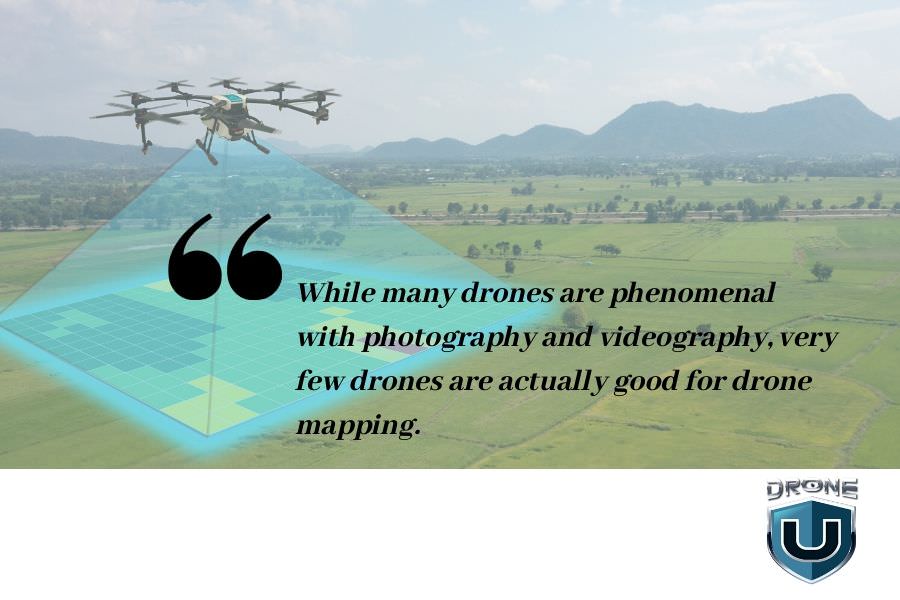
Who will build the next Honda Civic of drones? I know it sounds kind of silly, but it’s actually quite a simple question. Experienced drone pilots are looking for a drone that offers great video, high-quality images, and is systematically well-built for drone mapping. Now the ladder of those three is typically where most industry insiders showcase their lack of intelligence and knowledge in the industry as a whole.
When it comes to drone mapping, there are so many nuances and systems and systems inside of systems to ensure that drone mapping workflow is not only accurate but also reliable and repeatable. With a lot of construction companies needing to map on a daily or even weekly, certain drones simply do not allow for this to happen.
Why? It’s a very common problem.
And many people think that they have a firm grasp of this problem – frankly, they do not. Because we’re all lazy ultimately, and without really digging down into the nitty-gritty details, we’re often going to find ourselves lost in a pool of information.
The drone industry is one specific entity that requires such detail and nuanced knowledge and information. It’s the same lack of practical knowledge and nuanced information, in my opinion, that’s holding back our regulators from really allowing drones to take flight.
What do I mean by that? I really believe the lack of practical experience and flying drones in our regulatory body is crushing the industry because these officials do not even understand how to judge drone pilot operations. And they even mentioned that in the last FAA DAC meeting that took place.
Now, why are we asking for a Honda Civic of drones? We’re looking for a drone that typically has a global shutter and can articulate flight maneuvers that small drones cannot. They can handle wind, they can fly at night, and they have great flight times.
Also, they work all the time, are reliable, and you can repeat the processes over and over. This has been one particular problem with the enterprise series of drones, as there are many nuanced applications and workflows for these expensive drones. Because of these complexities and nuances, the enterprise drones have no clear systematic means of executing workflows. From one enterprise vehicle to another, it makes it extremely difficult to scale operations at your company or program. That’s why we are asking the question.
Who will be the next provider of the Honda Civic of drones?
The DJI Phantom 4 Pro was probably the best drone ever made. While the DJI Phantom 4 Advanced gave you maximum bang for the buck.
Well, why do I say that? With a Phantom 4 Advanced, we don’t have the obstacle avoidance that we would have on a Phantom. But if you’re a good pilot, you probably don’t use it very much. That being said, the Phantom 4 Advanced also has a global shutter. Very important.
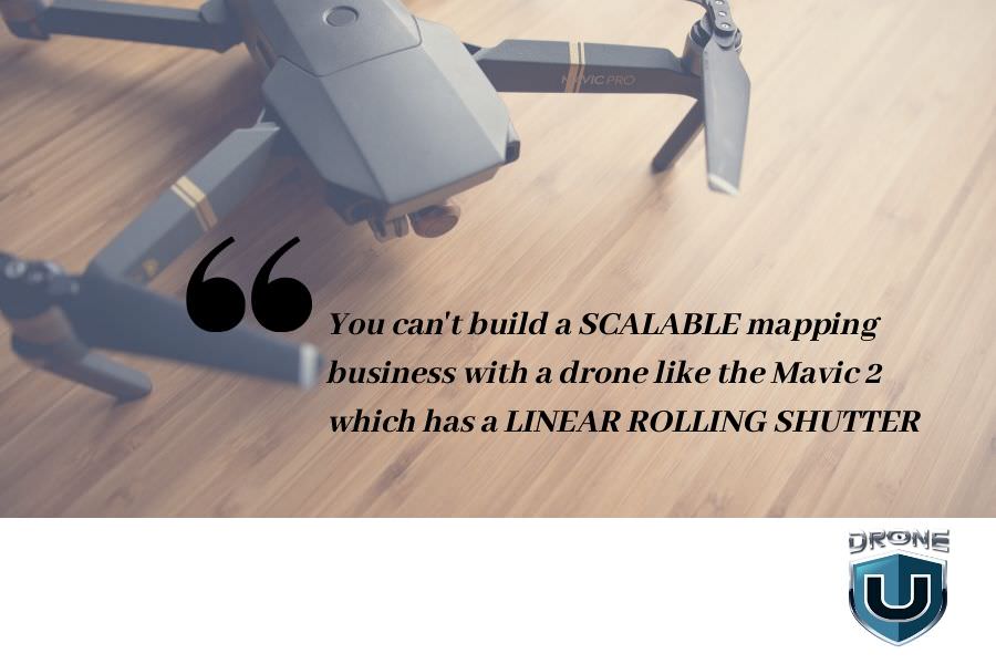
Global Shutter vs. Linear Rolling – Do You Need a Global Shutter to Run a Profitable and Scalable Drone Mapping Business?
And I’m not talking about a mechanical shutter or an electronic shutter. I’m talking about a global shutter, where the image readout is the entire sensor at one particular given time.
Many people do not understand the problems with linear rolling shutter cameras and global shutter cameras. A linear rolling shutter camera is able to conduct drone mapping missions. But a lot of people don’t understand why the knowledgeable and experienced drone pilots hate linear rolling shutters.
It comes down to the practical question. Can you run a business off of a drone with a linear rolling shutter?
The answer is NO.
And here’s why. Typically, when I’m flying a Phantom, I can, let’s say, map a 10-acre area on a double grid mission in about 18 to 19 minutes. That same mission would take three to four times as long to fly with a drone with a linear rolling shutter. Well, why? It’s because the drone has to fly in safe mode, or a much slower flight mode, so that when the images are taken with a linear rolling shutter camera, the images are not distorted.
Why do the images get distorted?
Well, a linear rolling shutter camera is a lot like a copy machine. You get that long sweeping swipe from one side of the image to the other side. Now, why is that a problem? Well, if we’re trying to measure one place and distance to another in one image, the image must be taken at the same time. Otherwise, in addition to image distortion, there’s also going to be distortions in the calculation.
Now, many industry salespeople and consultants say that there’s a correction for the linear rolling shutter issue.
Whenever someone says that it instantly tells me they do not know what they’re talking about when it comes to drone mapping because while it may take three to four times as long to acquire the same imagery, it now takes twice as long to process the same imagery as global shutter imagery.
So if I increase the acquisition time four-fold, and increase the processing time two-fold, it shall become nearly impossible to scale my drone operations at volume. Generating a drone map every single day is out of the question because my computer simply wouldn’t be able to keep up.
Now DroneDeploy has solved this particular issue by allowing cloud processing of mapping images. And while DroneDeploy may be the absolute best at ortho-mosaic construction in the industry. It’s the absolute worst when it comes to 3D textured mesh or 3D data in my opinion.
While Pix4D is the industry leader when it comes to point cloud construction, Pix4D has allowed everyone to essentially create any possible deliverable. They just don’t make it easy for you to export said deliverable in a nice beautiful format that your client is going to respect. This is why oftentimes, a lot of construction companies are choosing to work with companies like DroneDeploy, or Propeller Arrow when utilizing high-quality accurate data to solve database problems.
Now in construction, if I need to map the area every single day to understand if my contractors are pouring as much concrete as they say they are, I need to be able to map every single day. I need to have high-quality 3D data. So I don’t mean just shooting a single acquisition grid. I’m talking about double grids with obliques to ensure that I have the best possible data and no holes in my map.
For those of you who may be having trouble understanding where I’m coming from this problem is very simple. With a linear rolling shutter camera, it’s almost impossible to create beautiful 3D data to solve problems at volume. So if you’re trying to scale a drone program, it’s almost impossible.
So why do so many drone manufacturers choose a linear rolling shutter camera over a global shutter camera?
Well, it’s quite simple. It all comes down to the money. A liner rolling shutter is exponentially cheaper to manufacture than a global shutter.
But it just makes me wonder that now with all the issues that DJI has been having in the last year to produce a new drone, the doors have been opened up very wide to allow for another competitor to come in and manufacture a phenomenal mapping drone.
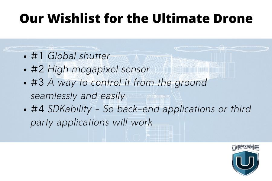
So What Does the Honda Civic of Drones Look Like? Our Wishlist….
Well, very simple. It looks like this. It’s a quadcopter or a helicopter that’s sub 400 millimeters from one motor to another. It’s a drone that can fit in a backpack or in a small case that can be in a trunk, in a, in a fire truck in a police car, or can be you know, hiked up the side of a mountain. If there’s a plane crash that needs to be investigated. It’s a drone that always works.
It’s a drone that has a global shutter. It’s a drone that has some sort of obstacle avoidance, multiple IMU’s, multiple campuses and is easy to control from the ground. It must also have a concrete SDK that third-party developers can utilize to help control the drone for autonomous flight missions.
Also, we need a larger sensor, we need a sensor that’s not only global shutter, but now we need something that’s maybe 36 megapixels. 32 megapixels. This way more and more people can do drone mapping because the larger the sensor for drone mapping, the lower that people can fly. So people in the Pacific Northwest with hundred-foot trees are having difficulty with drone mapping and photogrammetry as they’re choosing to go and use LIDAR. Well, what if we had a larger sensor and we didn’t need to fly as low? What if we had a global shutter sensor so we don’t have to fly slow? And what if we had a reliable drone that we could input controls from the ground at any given time?
So what are the specifications of this magical Honda Civic of drones? Let’s start from the top.
We love 4K60 videos. We want 1080 footage at 120. In addition, we love the ability to have aperture control, and we love the ability to have full control of the sensor itself.
Most drone pilots like having attitude mode. Why? It’s the ultimate way to get the smoothest video possible, have ultimate control of the drone, eliminate any autonomous glitches and ultimately stop a fly away. If your drone doesn’t have attitude mode, it’s just a matter of time before you’re going to face some sort of catastrophic flight.
What else does this Honda Civic of drones have? Cheap replaceable batteries, long flight time, can fly in cold weather with you know, self-heating batteries. It also has an easy camera, maybe even interchangeable lenses. So that someone could do mapping at 24-millimeter equivalent, or maybe a 50-millimeter equivalent, which would provide so much power to not only photographers and photogrammeters, but also videographers as a whole.
One drone company could knock it out of the park if they had a global shutter camera, interchangeable lenses, over 25 minutes of flight time, and a two to three-mile flight and video transmission distance. That’s always the last part and I typically forget to mention that. This Honda Civic of drones existed. It was the Phantom 4 Advanced. Now if someone can create another Phantom for advanced with a little bit larger shutter, or excuse me, a little bit larger sensor, a global shutter, a great distance for video transmission, and something small enough that can be portable and flexible to fly just about anywhere. Well, that manufacturer is going to knock the next evolution of the drone market out of the park. Until then I’m excited to see that drone come to fruition.
Become a Drone U Member.
Do not forget to subscribe and listen to Ask Drone U, the #1 drone podcast on iTunes!
Is Drone Delivery the Next Needed Catalyst for Economic Growth?
Will Drone Delivery make Consumerism so Easy that Overall Growth Increases?
What am I trying to say that by that? What if speedier, more convenient online shopping not only helped increase Amazon’s revenue growth but has a ripple effect on the entire economy? Let us consider Boeing – one of the biggest supporters of the Dow on the New York Stock Exchange. Currently, we are witnessing how the 737 MAX issue is having a direct effect on the national GDP.
With that said, my idea stems from the fact that ultimately, our economy is run on consumerism.
What if we can speed up consumerism in a way that’s a force multiplier? What if we can speed up the economy as a whole because it’s simply so much easier to buy things?
Yes! I think drone delivery will literally make things so easy to buy through not only Amazon but retail outlets as a whole.
Here’s what I’m getting at. Imagine that we have Amazon who is essentially arbitrage for every small business in America – which was great until they launched the ability for third-party sellers to originate outside of the United States. Then our whole 2-day Prime became more of a fantasy than a reality. Well now as Amazon tries to figure out how it will deliver faster, it was one of the first to get a part 135 certification from the FAA to allow for an air carrier service operated by a drone.
Now, Amazon has always been at the forefront as far as drone technology is concerned. They even offered me a job four and a half years ago to join the Amazon Prime Air team.
Can Amazon Drone Delivery Have a Ripple Effect on the Entire Economy?
I believe a corporate giant like Amazon can single-handedly increase the nation’s GDP. How? Well, imagine if drone package delivery can bring the delivery time to 60 minutes? Or, even 30 minutes. Yes, I mean, it’s literally as easy as getting a pizza. But that pizza is whatever the hell you want it to be, including the shiny little rubber mouse toy for your cat. This being said, if Amazon can drastically shorten the time from purchase to delivery, what gross effect will it have on the economy as a whole?
Well, I’ll tell you this. How do you feel when you go out to a store and there’s a long line in one of your favorite stores where it’s typically quick and easy to get in and out? Yeah, you’re probably a little flustered. You start to get a little nervous because this trip that used to take five minutes is now about to take 20. But the quality is unprecedented anywhere else. So you’re going to do it anyway.
Well, imagine if you could get the best quality Items all the time in under an hour with just a click on your phone. Can you imagine how fast your kids will run out of your bank accounts, parents? Yes, I really do believe that we’re getting to that time. I really do believe Amazon is going to create such a competitive advantage. It is also going to force all the other retailers to somehow, in some way, work together in order to compete with Amazon.
How Drone Delivery Systems Could Help Local Mom & Pop Stores Compete with the Likes of Amazon
So here’s the second piece that I was mentioning. What if retailers create some sort of association and aggregate a way to cover the cost of building drone ports at the mall? So your malls now turn into distribution hubs that have a well-automated system that runs through the store just like you would see a B&H Photo in New York City in Manhattan. Yeah, this already exists. Here’s the thing now. Take it in every single store in a mall and have that mall, literally go up to the helipad and single-handedly to packages in sub-30 minutes. Now Amazon has a real competitor and everyone can support their local stores.
“This is my vision of the economy moving forward. This is where I think it’s going. And here’s the thing. If Amazon can drive consumerism, the real driver, then our economy is going to be on fire”
So it makes me think, will the economy slowdown in the years to come? Probably. Could we save it with drone delivery and increasing the convenience to buy everyday items? Maybe!
Become a Drone U Member.
Do not forget to subscribe and listen to Ask Drone U, the #1 drone podcast on iTunes!
Practical Tips for Flying Safe
The FAA is actively promoting Drone Safety Week through advertisements, blog posts, podcasts and more. This hype has led to an overdose of information, which is often put together just to get some clicks. We thought it would be a fantastic idea to give you some practical and actionable information. So, let’s go over some tips for flying safely.
Tip #1 – Monitor your Drone Battery Voltage
Are you looking at the correct indicator for your battery? One of the biggest issues that we see with drone pilots all the time is that they’re not factoring in how much flight time they have left. Besides, they’re not factoring in environmental factors when it comes to figuring out how much flight time is truly left.
With that said, there is one true indicator that will allow you to have a very, very firm understanding of exactly how much battery power is left on your drone. And it’s not the battery percentage. The battery percentage does not give you an accurate representation of how much battery power you have left to remain in flight.
The BATTERY VOLTAGE is the true indicator of what’s possible with your drone. We have found that most drones do showcase battery voltage, and typically the consumer drones showcase battery voltage per individual cell in the battery. Since most of these Lithium-Ion, Lithium-Polymer, and Li-HI batteries operate in a certain voltage range, it’s very easy to understand when a safe time to come home truly is. Whether it’s 20 degrees outside or 100 degrees outside, your flight is going to be limited whether it’s too cold or too hot. So how will you know if your battery percentage is accurately telling you how much flight time is left?
And that’s why we teach all of our members in the flight mastery class about battery voltage and having it displayed on the main screen. In DJI, you essentially just click on the battery percentage, scroll to the bottom of that menu and turn on “Show voltage on the main screen” to have it displayed. When the voltage is at 3.60 volts, you know it’s about time to fly home. Whenever it’s 3.60 volts, you should have enough flight time, no matter the temperature to have at least 1500 feet to 2000 feet of “runway to make it home”. As someone who doesn’t trust this smart return to home feature and all the other battery settings, this has been one diagnostic indicator that is proven itself over time with our over 30,000 students.
Tip #2 – Observe the THREE Rules for Safe Drone Takeoff
Something else that we always teach everyone in the Flight Mastery class which is our flagship class and even required by the NTSB for this accident investigators,This practical tip is all about saving yourself and saving the drone upon takeoff. I cannot give you all the rules of takeoff because then I would devalue our material. Our training material is backed by hours of painstaking research and real-world experience, and you’re not going to find any of this stuff on YouTube. And that’s why we’ve never put it out. If you’re expecting to learn how to be a professional pilot from YouTube, you’ve got a lot of lessons coming to you. That being said, let’s go over the first two rules of takeoff and I will negate the third because it’s one of the most important and it’s one of the secrets of Drone U. Here goes –
Rule Number #1 – Always Takeoff into the Wind
Why should do always take off into the wind? Well, number one, it’s going to increase the thrust. And number two, it’s going to help you just get off the ground quickly and decrease the propensity of error during takeoff.
Rule Number #2 – The Drone and the Pilot Should ALWAYS Have the Same Orientation
Now, why is this important?
Well, let me tell you a story. One time I was shooting a little Netflix production down in San Diego with one particular producer who’s still one of my good friends. And he had actually put his drone on top of a Phantom case during takeoff.
And he’s got the drone facing him instead of the drone facing away from him.
I stopped him and I said, “You may want to turn the drone around because when you have the drone facing you, the roll and pitch sticks are inverted”.
He said, “Oh, no, I’m fine”.
He proceeded to takeoff and then hit the leg of one of our Drone U members, Brian. Sorry, Brian!
But it goes to show the importance of the second rule of takeoff. The drone and the pilot should always have the same orientation. Because if you have a gust of wind, if you have someone walking the way bird flies in front of the drone, at least the drone input commands will remain consistent. If the drone has an opposite orientation, your brain is not going to have enough time to realize that and you’ll end up making an error and crashing the drone.
Rule Number #3 – For DU Members Only
The third rule of takeoff. Well, we’re just going to save that for our members How about another practical rule of flight?
Tip #3 – Be Wary of Magnetic Interference
Whenever you’re in the field, getting ready to fly a particular location, what are the first things that you do? Well, we instruct members to look for factors that could obstruct their flight.What potential wireless interference or magnetic interference could have significant problems or cause significant problems to the drone industry? Are there wires around power lines, or a group of people in one particular direction? Well, upon looking at all the different obstacles in the hopper in the operating environment, it’s the second most important thing to do after takeoff.
Now that you have you have reviewed your environment, you need to measure MOCA.
Tip #4 – Determine your MOCA
For the regulators out there who don’t actually fly drones, MOCA means minimum obstacle clearance altitude. This is essentially the minimum altitude that we should set our Return-To-Home. Now if you fly a Skydio 2, you won’t have to worry about this. But if you’re utilizing any other drone in this industry, the first thing you do is measure the MOCA, bring the drone home and set the Return-To- Home altitude. This is fundamentally going to save you in case you have an issue with your drone.
Tip #5 – Prepare an Emergency Response Plan
Now, what’s another practical tip of flying? Well, like manned aviation, you should go through some sort of emergency response training. I’m not talking about responding to an emergency. Rather, as a drone pilot, you need to know how to avoid emergencies altogether.So, for instance, what should you do you’re about to hit something?
Most of you will say, “Hey Paul, I have never even thought about this”.
Huge mistake.
Well, let me remind you of this little saying – “Thumbs up, Buttercup”. That’s right.
Left thumb up whenever you feel like something is going to happen.It’s simple. Well, it’s really hard to hit things if you fly over it. I can’t tell you how many times this has saved my students even in training.
Tip #6 – Invest in Quality Drone Training
If you don’t want to risk your future income, your family finances, and a profession that you love, then I recommend that you check out our Flight Mastery class.While we do have a lot of online classes to serve our community, I truly believe every single person should take at least one in-person class. It’s really difficult to explain the difference and how MUCH this will truly benefit you.
You may know a lot. But, there is a huge difference between “Knowing It” and “Doing it”.
Attending a “Flight Mastery” class will help you build the HABITS and ROUTINES for truly safe drone operations. And, no! Being safe isn’t lame. Being safe gives you all the information that you need to know to fly with more skill. I believe that this is critical. So if you want to be like the thousands of successful drone pilots who have taken our Flight Mastery course, I recommend that you do it.
This course is the only in-person drone operations course where you can earn an educational discount. By passing our check ride at the end of the class, you can gain a very special rate for your drone insurance. Why? Because one particular insurance company Sky watch.ai has realized that the systems taught at a Flight Mastery class do help build habits and routines for safe flight.
So if you want to join the ever-growing list of graduates, I invite you personally to a flight mastery class. And because we’re so keen on flight safety, I’m going to give you a 10% discount on any of our training available through the website. Just go to the Drone U Training Events Page to see all the courses that I personally teach and are coming up.If you go to in-person trainings, you’ll have the opportunity to get training in one of our 10 training locations throughout the United States.
Signing Off…
Hopefully, you enjoyed this information that will help you to not only fly safer but with more skill and confidence in the field. I truly enjoyed the opportunity to share this information with you, and hope that you, like me, realize that being a lifelong learner is critical to the success of yourself and your family over the long term. So if you’re like me, and you’re a lifelong learner, then come fly, have a good time by going to a training that literally will save you the cost of the training over time by utilizing Skywatch. Thanks again.Paul
Become a Drone U Member.
Do not forget to subscribe and listen to Ask Drone U, the #1 drone podcast on iTunes!
Drone U’s Accident Mapping Class with Pix4D and NTSB
Accident Scene Reconstruction using drone mapping adds another level of sophistication to an already complex and incredibly nuanced field. When legal decisions are being made based off your drone data, there is no room for any errors.
We, at Drone U have come up with a unique training that gamifies the entire learning experience.
Is There a Pressing Need for Better Drone Training?
Contrary to popular perception, rather than data acquisition, it is data processing that is the most time-consuming aspect of drone mapping. And surprisingly, many drone trainings fall woefully short in this regard.
And yet, there are other drone schools that attempt to teach students the nuances of drone processing without walking them through different acquisition strategies.
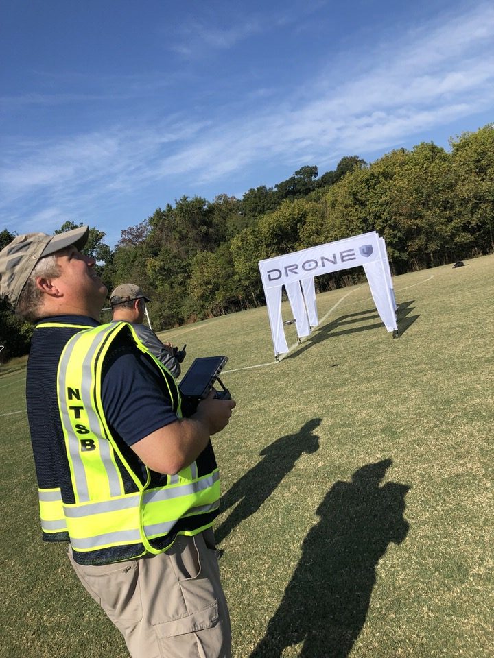
Recognizing these industry shortfalls, Drone U partnered with Pix4D to offer a carefully structured Accident Scene Reconstruction Training at the NTSB Training Academy.
What Did Students Learn Over the Course of This 3-Day Training?
Highlights:
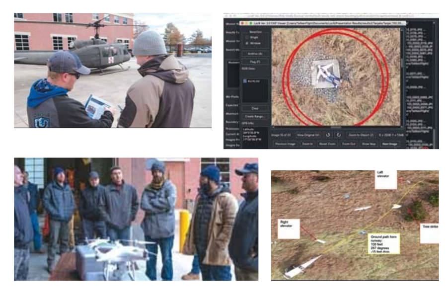
- Students had the unique opportunity to map a Cessna plane crash and a helicopter plane crash
- Students completed 3 practical flight-based missions that gamified the learning experience
- Students were taught how to use synthetic aperture radar mapping to create orthomosaic maps for search and rescue operations
- Students learned the nuances of Loc8 software
Details:
Day 1
Classroom training commenced with processing training taught by Pix4D’s Angad Singh. Apart from discussing topics like scale constraints and merging maps, Angad explained how students can recreate crash scene with survey-grade precision.
Day 2
Flying real-life missions is certainly the best way to test a pilot’s skills. So, on Day 2, our students took to the skies to fly three carefully structured missions:
Mission 1 – Map a small general aviation fatal accident
In this mission, students:
- Generated a 3D model of the accident scene
- Exported deliverables to make measurements
Students were provided with a guide that detailed the individual flight paths for processing in Pix4D.
Mission 2 – Map a UH-60 Helicopter
- Conduct a thorough damage assessment
- Prep a maintenance plan for headquarters
Mission 3 – Map an area to look for missing “victim” and helicopter parts
In this last mission, Drone U students were asked to look for hidden mannequin and helicopter parts. Students were asked to use Loc8 software to analyze images.
Day 3
On Day 3, students learnt how to:
- Use different workflow techniques for achieving highest level of accuracy for 2D maps
- Clean up 3D models and surfaces for orthomosaics
To learn workflow, students processed different models and learned the importance of scale constraints in relative space. Further, a demonstration of a new search-and-rescue software wrapped up the final day of the reconstruction class.
How Can You Attend a Drone U Training?
Drone U’s unique training model that emphasizes education via practical experience resulted in increased engagement and retention. Further, healthy competition among students encouraged them to put in their best effort.
As is evident from our student testimonials, this approach certainly seems to be a winning one. We shall be conducting this same training again in spring. Check out our website for updates and information about future trainings.
Become a Drone U Member.
Do not forget to subscribe and listen to Ask Drone U, the #1 drone podcast on iTunes!

How Being Prepared Allowed Me to Photograph a NFL Stadium
After someone pointed out that the FAA’s Stadium TFR is not active during NFL preseason games, I decided this was going to be one of my only chances to get an aerial photograph I always wanted.
As a Drone pilot living in Denver, CO, I love our skyline. And I love shooting it. Depending on where you’re shooting from, you have a variety of subjects. From the East you have the Rocky Mountains in the background. From the South you can get the Capital. And from the West, you can get Broncos Stadium at Mile High. And it’s that Western view I’ve always wanted to get. And I’ve wanted to get it from a drone, at night, with the skyline and stadium nicely lit up with cooperative weather.
For me to get that shot, it has to be during a preseason game, at sunset, when the Colorado Rockies are also not playing. That same NOTAM also applies to Coors Field, because Mile High is close enough to Coors for the either NOTAM to affect both venues at the same time. So no Rockies’ game can’t be going on either. So on the night of 8/19, all of the stars aligned and I was given a chance to get the shot I wanted.
How Did I Check for TFR’s?
As a Drone Pilot who tries their best to follow the rules, I put the question out in one of the forums to get some input on whether I was reading the NOTAM right. I got corroboration from people I trust. I then checked with Flight Services (1-800-WXBRIEF), and they checked with Skyvector. All said I was clear to fly. And at [5:00], when a TFR would go into effect, I checked the FAA TFR site one more time to be sure. Still all clear.
As a matter of fact, the only resource that showed an active TFR for the game was Airmap. Yet another mistake, in the long list of mistakes by them. So I gave myself and my VO, Todd Pierson, the green light to fly, packed the DJI
Mavic 2 Pro (my go-to drone these days) in the Yukon, and off we went.
But first, I had the presence of mind to print off 6 copies of NOTAM 7/4319, and highlight the parts of that NOTAM showing we can legally fly during NFL preseason games. I put those in my flight bag.
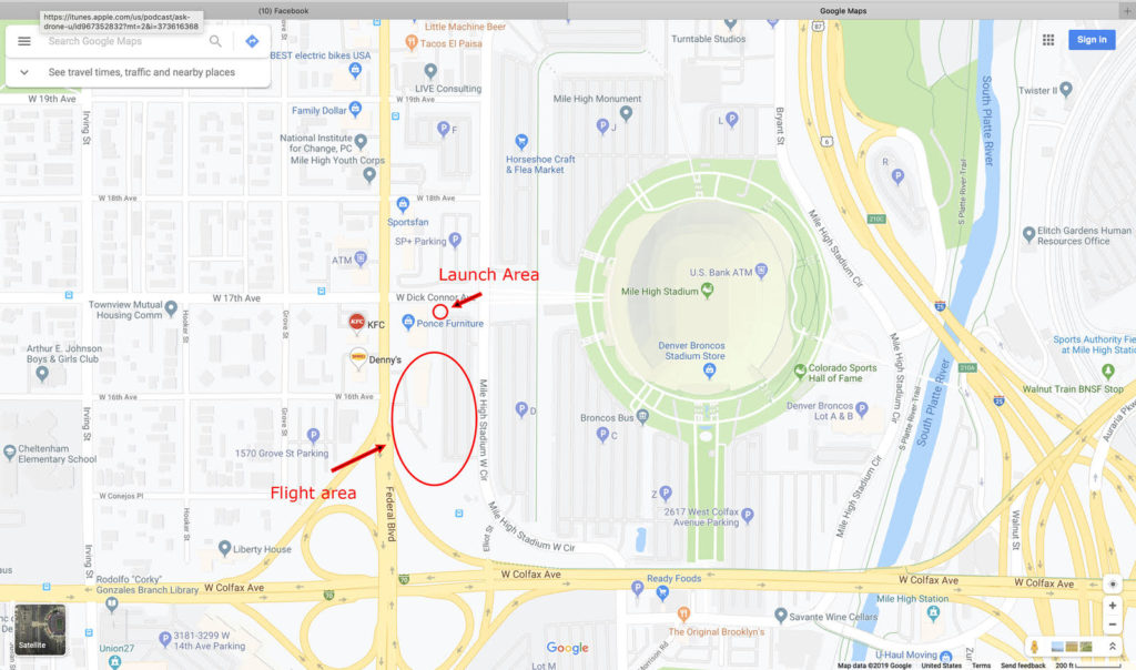
The next challenge was finding parking. We didn’t want to get there until about an hour after game time, so the usual areas were full. Todd knew of a spot, so we parked about 6 blocks away and walked.
Everything was good so far. We knew that flying from any property owned by Mile High Stadium was off-limits, so we asked if we could fly from an adjacent parking lot. We were told no, so we decided to fly from a sidewalk, which we knew was legal. We wanted a parking lot to be away from crowds. Obviously, that would have been the safest route. But that ended up not being an option.
Instead, we powered up on the grass near a sidewalk, obtained GPS and home lock, waited for a clearing in the crowds, moved the M2P to the sidewalk and lifted off. This is probably a good time to mention that I knew Mile High runs a DJI Aeroscope drone detection system. So I was pretty sure someone would come pay us a visit, hence the printing of copies of the NOTAM.
How I Dealt with NFL Security and FBI
So, we lifted off, immediately flew over to the parking lot for safety, and double-checked my telemetry as always. Everything looked good so I went up to 400’ to start shooting. About 5 minutes later it got interesting. Todd and I noticed a guy in a golf cart headed our way, so we knew he was looking for us. We were not trying to hide. We were wearing our Hi-Vis vests, and had the case and flight kit sitting on the ground next to us. And let’s face it; if you’re flying a drone, it’s pretty obvious already.
So, the gentleman comes up, I introduce myself and shake his hand, and he politely said we needed to land our drone. When I (politely) asked why, he said it was NFL policy. Todd handed him a copy of the NOTAM, and I mentioned (also politely) that actually it’s an FAA policy, however, it doesn’t apply to preseason games. I also
mentioned that I would be happy to talk with him about it, but since I was flying I wanted to land first. However, I wanted to get some more photos first. He seemed happy with that response.
He then radioed and told whoever was on the other end of the coms that I had a piece of paper that said I could fly. He then asked me to land again, which I did. Once I landed he asked for my ID and for us to take the battery out of the drone. Removing the battery was a strange request, but we complied. No problem. He took photos of my ID (I have no problem with that), and photos of the Mavic’s serial number and registration number (which I have on the outside). And about that time, two of Denver’s finest (Police Officers) also showed up. We gave them a copy of the NOTAM and explained the preseason rules as well. Then the second officer asked if he could have a copy for his records. He hadn’t seen it before.
Everything was going fine, there was no tension, but I just wanted to get back up to shoot some more. They said I needed to wait for head NFL security for Mile High. Again, no problem. He showed up about 2 minutes later, I shook his hand and introduced myself. I started to give him a copy of the NOTAM and explain it didn’t apply to preseason games, but he said he all knew that already. He just wanted to come out and make sure everything was in order, and I was following FAA regulations.
It was very refreshing to have someone show up who was familiar with the rules. We came to a compromise about me not flying over any of the stadium property, including parking lots. He agreed that he technically couldn’t stop me, but he was worried that if I got too close stadium, someone would see it (I was running strobes, again for visibility, I didn’t want to appear to be hiding) and there would be a panic. It’s very unlikely that would happen, but it’s a possibility. So I took off again, and put the drone up over the buildings just next to the parking lot. It was a very good location, if not ideal.
Discussing Drone Regulations and Lack of Enforcements with the Feds
While I was flying, Todd and I noticed that the guy in the golf cart and the NFL security guy stayed around and were on the phone. Apparently, the FBI got involved at that point. Security wanted to confirm everything with them. Just as I was about done, a black SUV pulls up. And out pops the FBI. That’s when things got interesting.
Introductions were made and the FBI agent started to explain things to me. When it was obvious I knew the rules, and was being safe, his demeanor changed for the better. His original tone can be easily explained by the fact that I was the first drone operator they’ve contacted during Broncos games that had my poop in a group, was educated in the rules, and was flying legally and safely.
They also mentioned that about 1 in 10 people they contact actually have their drones registered. And when confronted, are clueless that they even needed to. That bothered me quite a bit.
One thing lead to another, and the agent, head of security, and myself, spent about 15 minutes talking about the different regulations, Aeroscope (the stadium loves theirs), and new regs coming down the pipe. And amazingly enough, they also brought up that if there was more enforcement, their jobs would be easier.
I’d like to reiterate again that this is an FBI Agent and the NFL Head of Security bringing up the lack of enforcement by the DOJ and DOTOIG. And they want to see more. I did not bring up enforcement. The agent and I both know the area LEAP agent, and that he has way too much area to cover. They do not blame the FAA for this.
Another outcome of last night is that I now have the contact info for the local head of NFL security, and the contact info for the FBI. And the NFL security just said to let him know if I want to fly again for the next home preseason game. He’ll pass it down the ranks to let everyone know it’s just me.
And, I asked them to pass along my contact info to the people they come across who don’t know the rules. After all, it’s up to all of us to help educate the new drone owners. It’s in our best interest to do that (nicely). They loved that idea.
Some Final Thoughts – Could I Have Done Anything Differently?
So what could I have done better? I really should have given them more than one day’s notice that I was going to fly. When I told them I emailed the stadium the day before, they laughed. They asked if I really knew how many emails the stadium got every day, much less the weekend before a game. I really didn’t consider that. 3 or 4 day’s notice is best (more is better). And only count actual business days, not weekends. Other than that, they said everything else I did was perfect. They all appreciated the copy of the NOTAM.
So what is the take away from last night that I can pass along? Be prepared. And be cordial. Make sure you know what you’re doing, and be 100% prepared to nicely explain the rules to whoever shows up. Because odds are you’re the most educated person in that entire situation. It was VERY refreshing to have two of the 5 responding
security folks to know the actual rules. But based on stories I routinely hear, that is for from the norm.
Be ready to de-escalate the situation if necessary. And don’t push your point. In reality, if they want you to land, just land. Even pack up and call it a day if necessary. The agent even pointed out that although he can’t enforce the FAA’s rules, he can most certainly confiscate your equipment and start a criminal investigation into the flight. And who wants that? The attitude of the drone operator is usually the determining factor of the outcome of the situation.
I missed what I thought would be my perfect light last night while all of this was going on. I didn’t get the sunset I wanted. But I should have planned things a bit better and showed up earlier. I’ll take fault for that. If you show up early enough, you have a chance for all of the concerns to be addressed and you can get back up in the air in time. And to be fully transparent, I think the later shots turned out better anyway. So in this case, there was no loss.
I hope my experience from last night can be helpful to all drone operators and responding enforcement folks. If everyone keeps a cool head, and things remain friendly, we all win. Fly safe, have fun, and make awesome imagery!
-Vic Moss
Moss Photography/Drone U
Vic Moss is a commercial photographer with over 30 years experience. He is also a national voice for drone safety and reasonable drone regulation. Vic has worked with numerous cities and states to help craft drone regulations that don’t inhibit safe and responsible drone use. Vic is also a FAASTeam member and one of three UAS specialists in the Denver FSDO Service Area. As a frequent contributor in many UAS forums, Vic keeps tabs on the pulse of all things UAS. Vic’s duties as a co-owner of Drone U include photography instruction, legislative liaison, and Elite pilot instructor. Vic was recently appointed to the FAA’s Drone Advisory Committee Waiver Task Group. You can get in touch with Vic by emailing him at [email protected].
More blog posts by Vic Moss
Become a Drone U Member.
Do not forget to subscribe and listen to Ask Drone U, the #1 drone podcast on iTunes!
Part 107 License FAQ | Your Drone Certificate Questions Answered
This document contains answers to some of the most common questions that pilots have about getting their Part 107 drone license. Once you read these common questions, chances are you’ll be ready to take flight and turn that passion into profit!!
1. What is Part 107? How Can You Get Your Part 107 License?
If you like flying drones it’s likely you’ve heard of the term “Part 107.” The rising popularity of drones for commercial applications prompted the FAA to come out with Part 107 regulations in 2016. Under these regulations, drone pilots are required to pass a Part 107 knowledge test and get their Part 107 certificate before they can fly their drone commercially.
Now that the FAA has required recreational pilots to pass a test as well! Makes you wonder why not just take a few extra questions and start earning money with your drone?
Typically, most drone pilots who love to fly recreational drones are literally nervous or afraid that they will be unable to pass the Part 107 exam. DON’T BE. IT IS EASY. AS LONG AS YOU FOLLOW THE FORMULA, YOU WILL PASS. New pilots, now, only have to take the test once, there is no longer a recurrent test.
2. Do I need a Remote Pilot’s Certificate to Fly a Drone?
A Remote Pilot Certificate (a.k.a. Part 107 license) is mandatory if you plan on flying your drone for all non-recreational purposes. Part 107 rules are applicable for all drones weighing less than 55 pounds and used for non-hobby purposes. If you are flying a large drone weighing more than 55 pounds, a Part 107 license will not suffice. You will have to apply for an exemption under the Special Authority for Certain Unmanned Systems (which has replaced Section 333).
If you are planning only flying for recreation and/or hobby purposes, you do not need a Part 107 license. Albeit, you will have to pass the FAA Trust Test. Recreational pilots now have to apply for LAANC airspace authorization to fly in controlled airspace. With all these new regulations on hobby pilots, why not just get the Part 107 and not deal with the headache? You can fly with more freedom and less stress, seems like a no brainer?
And if you are a manned pilot with a Part 61 private pilot license, the process is much simpler. But you still need to get your 107 Remote Pilot Certificate. There are a few conditions to getting your 107 under your Part 61 license. These are the conditions for commercially flying drones with a Part 61 license –
Hold a pilot certificate issued under 14 CFR part 61; and
Have completed a flight review within the previous 24 months; and
You must take a small UAS online training course provided by the FAA; and
Keep you Remote Pilot Certificate card “easily accessible by the remote pilot” you when you’re out flying.
As a drone pilot, what you make is dependent on your skills and experience. According to our research, Payscale reported a drone pilot salary range of $43,886 – $128,401. Whereas, Glassdoor reported an average base pay of $65,336 and a range of $25K-$90K. However, these stats represent the greater majority, and like in any business, there are outliers who are far ahead of the pack.
Broadly speaking, there are two ways to increase your income. The first approach is to take on simple jobs like real estate and scale up your business through efficient execution and clever marketing. Check out our webinar, “How to stand out in the competitive real estate market with deliverables that realtors will love” if you wish to take this route.
The other option for increasing your drone pilot salary is to go after complex jobs like powerline inspections, cell tower mapping, and subject tracking.
So, what is the maximum drone pilot salary that you can possibly earn? Drone pilots who offer their services to on-set productions earn some of the highest salaries in this industry. Pilots who are flying the Freefly Alta with a sophisticated drone camera can earn anywhere between $5K- $13K per day depending on their level of skill. Check out our ADU show, “Freefly ALTA 8 Pro or DJI – Which Is Better Option for Drone Mapping?” to learn more about the Freefly Alta 8.
Want to see what real drone pilots are making right now? Make sure to check out our drone pilot salary guide. This way you can learn from actual experienced entrepreneurs | drone pilots.
4. How Do I Get my FAA Part 107 Drone Certification?
How to Get Part 107 License in 5 Simple Steps:
1. Study Hard (We have 3 different Part 107 Classes to Appease all Learning Styles!)
2. Schedule and pass your drone certification test at a Part 107 Testing Center
3. Complete the online IACRA Application to receive a temporary Part 107 card via email
4. Pass TSA Background Check
5. Receive your physical Part 107 card in 30-90 days
Until your physical Part 107 card comes in the mail, print out your temporary card and keep that with you. Your official Certificate number is “Pending” until your permanent card arrives.
Check out our Drone Pilot License Guide for detailed, step-by-step instructions.
So, how can Drone U Help you clear your Part 107 Exam? As a Drone U member, you receive –
FAA Part 107 Study Guide FREE!
A Comprehensive FAA Part 107 Online Course
FAA Part 107 Practice Test and much, much more…
Drone U members who consistently score 90% and above in the FAA Part 107 Practice Test have a very good chance of clearing the Part 107 test on the first attempt itself.
Check out reviews page where our Part 107 students share their awesome experiences.
ONCE you pass the 107, now the fun begins. To truly be successful you’ll have to practice your operations and missions. In addition, you’ll have to setup your business to scale from the start.
Drone U members gain access to all these classes that we currently have. I’d recommend the DCC, operations course, subject tracking and Kara’s business class. All of these classes are included with your membership.
5. How Many Questions are on the FAA 107 Test?
The FAA 107 test consists of 60 questions. To clear this test and get your Part 107 license, you need to get a minimum passing score of 70%. This means that you need to get at least 42 questions right. You will have 120 minutes or 2 hours to complete this test. The Part 107 recurrent knowledge test has 40 questions, and you have 80 minutes to complete this test.
6. Is it Difficult to Learn Part 107 Airspace?
This is a question that aspiring drone pilots often ask us. The Part 107 Airspace section is difficult to learn without the right guidance. Fortunately, we have FAA Certified Flight Instructor Ted Wilson who teaches airspace in his own unique way in our FAA Part 107 Online Course. Among other things, you will learn –
The different categories of airspace and how to remember them
How to read sectional charts
Controlled vs. Uncontrolled Airspace
What are “warning areas”? Can you fly in “warning areas”?
How to check for NOTAM’s
7. Does Drone U Offer an FAA Part 107 Practice Test?
Absolutely. We have a comprehensive online test which exactly simulates your Part 107 experience. If you consistently score 90% and above on your Part 107 practice tests and quizzes, you are ready to pass the Part 107 exam.
Click here to check out our Part 107 Practice Test. 
8. How Much Does the Part 107 Test Cost?
Part 107 test cost is an affordable $175. Of course, you need to get a passing score of 70% or higher to avoid retaking the test. Note that this cost does not include the cost of your Part 107 test prep.
9. Where Can I Take My Part 107 Test? How Do I Find a Part 107 Testing Center Near Me?
There are more than 300 Part 107 Testing Centers in the United States. And, it is likely that you will find one near you. Check out the entire list of Part 107 Testing Centers. Once you find a testing center near you, you can easily schedule your test by calling CATS at (844) 704-1487.
10. How Long Does it Take to Get Part 107 License?
Frankly the time that it takes to study and acquire your license varies from person to person. We have seen people do it in a few days to a week. We have also used data to realize that the average time to study then take the test is about 18 days.
11. How Long Does a Part 107 Certificate Last?
Your FAA drone certificate is valid for two years from the end of the month of your initial Part 107 Exam. Be sure to renew your commercial drone certificate before it becomes non-current.
12. Could you Walk me Through the FAA Drone Registration Process?
If you’re a Part 107 commercial pilot or you’re a hobby pilot and flying a drone weighing less than 55 pounds, you need to register the drone though FAADroneZone. Registration cost is $5, and your registration is valid for 3 years. According to FAA requirement, you also need to label your drone with your registration number ON THE OUTSIDE OF YOUR DRONE. In order to register your drone, you will need –
Your Email Address
Make and Model of your drone
Your Mailing Address
Credit or Debit card
Update: Also FAA has not released remote ID protocol yet, so make sure to check the box that your drone is not RID compliant. (The FAA needs to release the protocol so the industry knows what is RID compliance)
Check out our instructional video, “Navigating the FAADroneZone” for more information on this. If you are a part 107 pilot flying a drone larger than 55 pounds, you need to register your drone as “non-modeler” with the FAADroneZone.
13. Which is the Best Drone for a New Drone Pilot Like me? What about Drone Accessories?
If you are a new drone pilot, you will likely start with simple jobs like real estate photography and videography. However, as you progress to more complex and lucrative drone jobs, your requirements will change accordingly.
Many new drone pilots start with a DJI or Autel drone. The two most popular drones are the DJI Mavic 2 Pro or DJI Phantom 4 Pro. DJI commands much of the U.S. drone market and is very popular. Autel also makes a drone called the EVO 2. While not as advanced as the Mavic 2 series, it is a very good drone, not only to begin with but also to continue to use.
Both the Mavic and Autel series are good drones for aerial photography and videography. And since it has a 20MP sensor, the Mavic 2 Pro (not Zoom) is also good for some of the lower end inspection projects, like roofs and some cell towers. The Mavic 2 pro offers the best camera control and color depth, and frankly takes amazing video. If you’re looking for 4k 60fps, stick with the Phantom 4 Pro for video. Considering getting into mapping? Then stick with a Phantom 4 Pro.
As far as accessories, additional batteries are always recommended, as is a hard-sided case from GoProfessionalCases for safety during travel. And a landing pad is a must for those locations where a clean launch area is not available.
Check out our in-depth Mavic 2 Pro Review and Autel EVO Review.
Drone U Recommendations –
Best Drone for Aerial Videography and Photography: Mavic 2 Pro
Best Drone for Mapping: Phantom 4 Pro
Most Versatile Drone: Inspire 2 Pro
DJI Alternative: Autel Evo or Parrot
Click on this link for a complete list of drone accessories.
14. Where Can I Fly my Drone?
You should know the answer to this question after taking the class. When it comes to operational requirements, there are requirements besides airspace that you must be aware of. Once you have bought your drone, this is the next question that drone pilots ask us. First of all, you cannot fly your drone BVLOS or Beyond Visual Line of Sight. Secondly, you cannot fly your drone higher than 400 feet AGL (Above Ground Level).
These are some resources which make it easy for you to determine where you can fly and where you cannot fly –
FAA Visualize it
tfr.faa.gov
Skyvector.com
Airnav.com
UASideKick
For a more detailed breakdown on these topics, check out our show, “Where Can I Fly My Drone? Should I Rely on Drone Apps for Checking Airspace?“
15. As a Commercial Drone Pilot, Do I need to Buy Insurance for my Drone?
Certain US states have made it mandatory for pilots with a Part 107 License to purchase drone insurance. However, even if the law of the land does not require that you purchase insurance, we strongly recommend that you do so. For what to buy, and how to buy, check out our comprehensive, Drone Insurance Guide. Many Drone U members have been earning their educational discount and acquiring monthly insurance through Skywatch.
16. How Do I Use LAANC to fly in Controlled Airspace?
In order to fly in controlled airspace, you will have to seek FAA’s approval using their LAANC system (Low Altitude Authorization and Notification Capability). Two of the most popular options for getting LAANC approval are the Kittyhawk mobile app and the Skyward website. Check out our blog post, “LAANC Apps – Using Kittyhawk and Skyward for Approval” for more information on this topic.
17. Does a Hobby Pilot Need the Approval to Fly in Controlled Airspace?
According to new FAA drone rules, hobby pilots need airspace approval by using LAANC or FAADroneZone for flying in controlled airspace. But, only LAANC providers are equipped to handle the requests. Because FAADroneZone is not yet equipped to handle requests from hobby pilots, the new FAA drone rules ban hobby pilots from flying in controlled airspace, at least for now.
Become a Drone U Member.
Do not forget to subscribe and listen to Ask Drone U, the #1 drone podcast on iTunes!
Flying Large Drones Over 55 Pounds Using Section 333 Exemption
In this blog post, you will learn how to fly large drones over 55 pounds using a section 333 exemption. Furthermore, we also compare FAA 333 exemption to Part 107. Which is the best option for commercial drone pilots? And why? Read on to find out.
Can You Fly a UAS over 55 pounds under Part 107?
It is a known fact that commercial drone pilots need a Part 107 certification to comply with the law of the land. However, when it comes to extremely small drones (weighing less than 250 grams [.55 pounds]) and really large drones (weighing more than 55 pounds), drone certification requirements are quite different.
For drones weighing less than 250 grams, commercial drone pilots do not need any certification at all. In fact, according to the industry rumors, the eagerly awaited DJI Spark 2 might fall in this category.
However, when it comes to large drones weighing more than 55 pounds, things are not so simple. Large drones are used for applications like crop spraying, drone deliveries, and LiDAR. The world’s largest drone, the Feihong-98 tips the scale at a large 5.25 tons.
According to the latest drone rules, anyone wanting to fly a UAS over 55 pounds will have to seek exemption under Special Authority for Certain Unmanned Systems (49 U.S.C. §44807). Section 44807 of the 2018 FAA Reauthorization Act replaces FAA 333 exemption of the FAA Modernization and Reform Act of 2012.
So, Can I No Longer Fly Under Part 333 Exemption?
No. Section 333 is not dead.
You can still fly your drone under a Section 333 exemption. According to the FAA website, a total of 5551 exemptions have been granted to date.
How do I File for a Section 44807 (Previously Section 333) Exemption?
Section 44807 of the 2018 FAA Reauthorization Act states that:
“Notwithstanding any other requirement of this chapter, the Secretary of Transportation shall use a risk-based approach to determine if certain unmanned aircraft systems may operate safely in the national airspace system”.
So, how does the FAA plan on implementing this risk-based approach to ensure the safety of the national airspace system?
These are some essential pointers for filing your Section 44807 Exemption:
- Describe the design and operational characteristics for the type(s) of UAS in as much detail as possible
- Training of PIC and flight experience matters a lot
- Describe your plan for ensuring safety
- Specify the proposed maximum operating speed and altitude, minimum flight visibility and distance from clouds
- You will need to obtain a COA too. The FAA issues a Blanket COA to everyone with a Section 44807 exemption. If you wish to operate outside the purview of a blanket COA, you can also apply for a full COA. To learn more about the different kinds of COA’s and how they compare to Part 107, check out our show, “Should public safety offices get a Part 107 or a COA?”
You can also check out FAA’s document, “How to File a Section 333 Exemption” for more details on this. Once you have reviewed this document, you can file your petition on the public docket.
Section 333 Exemption vs. Part 107 – Comparison
No doubt, getting your Part 107 certification is a far easier option. Let us first discuss the advantages of getting your Part 107 certification over a Section 333 exemption.
- Requirements for getting a Section 44807 exemption are far more stringent
For starters, only Part 61 manned aircraft license holders can apply for a Section 44807 exemption. Compared to this, there are no such requirements for getting your Part 107 license. Anyone who is above the age of 16, can speak good English and is in sound mental and physical condition can apply for a Part 107 license.
- You can get your Part 107 in just 15 days
Drone registration requirements for Section 333 exemption holders mandate that they must use the traditional Part 47 process. Part 47 is a cumbersome and paper-based process that takes much longer than Part 107.
While the entire Part 107 certification process can take as little as 15 days, getting your Section 44807 exemption can take as long as 120 days.
- Medical Requirements are far more relaxed for Part 107 aspirants
If you are applying for a Section 333 exemption, you MUST furnish a medical certificate
- Section 333 exemption holders must use Visual Observers at all times
Section 333 exemption holders must use a visual observer at all times. Using a VO is not mandatory for Part 107 license holders.
Section 333 Exemption vs. Part 107 – What are the Similarities?
- Both are valid for two years
- You are always required to maintain Visual Line of Sight
- You need permission to fly in controlled airspace
- You cannot fly higher than 400 feet AGL
You can check out all the requirements in this FAA’s application for a Blanket COA
Conclusion
Getting a Part 107 license is undoubtedly the better option if you are flying one of the popular consumer drones like the Phantom or Mavic. However, if you wish to fly a large UAS over 55 pounds, applying for a Section 333 exemption is your ONLY resort.
Become a Drone U Member.
Do not forget to subscribe and listen to Ask Drone U, the #1 drone podcast on iTunes!
Mavic 2 Pro Hack | How to Switch to Atti Mode in 5 Steps
If you want to make your Mavic 2 Pro or Zoom even better for video, you must learn to fly in Atti Mode. Because, how do you expect to get smooth filming motion WITHOUT Atti Mode? You can’t. Now, with this Mavic 2 Pro hack, acquire attitude mode for seamless video motions.


More on Hot Topics