Class C Airspace: A Comprehensive Guide [2025]
Did you know that flying your drone in restricted airspace could land you a hefty fine from the Federal Aviation Administration (FAA)?
And if you’re near an airport, there’s a good chance you’re in Class C Airspace. It is one of the most controlled airspaces in the U.S.
This means you can’t just take off and fly wherever you want. Even a small mistake can lead to an airspace violation, and that’s the last thing you would ever want.
That’s why understanding airspace rules is so important.
In this article, we’ll break down what Class C Airspace is, why it matters, and exactly how to get permission to fly legally.
Let’s begin by understanding the Class C airspace.
What is Class C Airspace?
Class C Airspace or Charlie Airspace is a controlled airspace around medium-sized airports with moderate to high air traffic.
These airports typically operate commercial and domestic flights, private jets, and charters. While they are busy, they are not as crowded as the major international airports.
The main goal of Class C Airspace is to keep air traffic organized and safe. It ensures that manned aircraft, like private jets and commercial airlines, follow structured routes.
Think of it like a highway interchange near a big city. The more vehicles merging in and out, the more you need clear and structured lanes and traffic rules.
The same logic applies here, it helps manage flights and reduces the risk of collisions.
Unlike uncontrolled airspace, where pilots are free to fly under basic FAA rules, Class C Airspace requires coordination.
That’s why, Air Traffic Control (ATC) actively manages this airspace, communicating with pilots to ensure safe separation between aircraft.
As a drone pilot, you won’t communicate directly with ATC, but you still need permission from the FAA before entering into Class C Airspace.
Now that you know what Class C Airspace is and why it exists, let’s see how it compares to other types of controlled airspace.
How Class C Differs from Class B and D Airspace
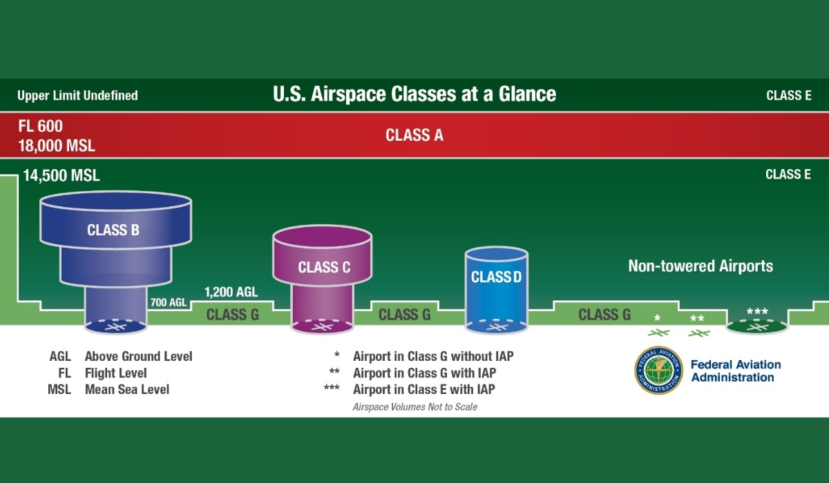
When you look at an airspace map, you’ll notice Class B, Class C, and Class D Airspace surrounding different airports.
Each of these comes with its own rules, and knowing the differences can help you avoid violations.
Class C Airspace falls somewhere between Class B and Class D. It’s more regulated than Class D but less restrictive than Class B.
It surrounds medium-sized airports with steady commercial traffic but without the high volume of major international hubs.
Think of these airspaces like different levels of traffic control at intersections:
- Class B is like a massive highway interchange—high-speed traffic, complex lanes, and strict controls.
- Class C is like a busy city intersection—lots of movement, but with structured traffic lights.
- Class D is like a suburban four-way stop—less traffic, but still some rules to follow.
Here’s a table to help you get more clarity:
| Airspace Type | Who Uses It? | Size & Structure | Drone Rules |
| Class B | Large commercial airports | Huge, multi-layered (up to 10,000’ AGL) | Strictest rules, special FAA approval needed |
| Class C | Medium-sized airports with commercial flights | Two-tier system extends up to 4,000’ AGL | FAA approval required via LAANC or DroneZone |
| Class D | Small airports with control towers | Single-tier, up to 2,500’ AGL | FAA approval often easier to get via LAANC |
Next, let’s take a closer look at how Class C Airspace is structured.
Structure of Class C Airspace
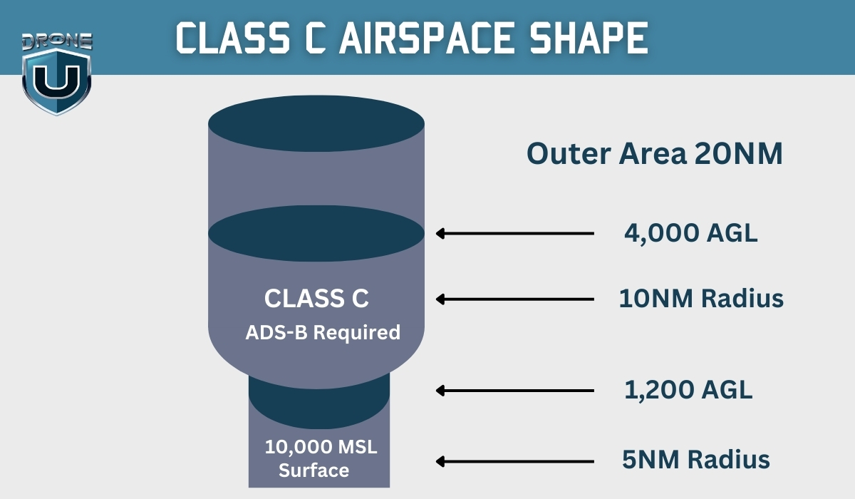
Class C has a layered, upside-down wedding cake structure designed to keep air traffic organized and separated.
Think of it like a two-story building, where each floor has its own access rules.
The lower level is closer to the airport and has stricter rules, while the upper level offers more flexibility for aircraft.
The Two-Tier System
The Class C Airspace tiers are named as:
1. The Inner Core (5 Nautical Mile Radius)
The inner core area starts from the surface (ground level) up to 4,000 feet above ground level (AGL) and has a radius of 5 nautical miles (NM).
This area is the most controlled because it’s where planes are taking off and landing.
2. Outer Shelf (10 Nautical Mile Radius)
This shelf extends from 5 to 10 nautical miles away from the airport. Unlike the inner core, this airspace doesn’t start at ground level.
It typically begins around 1,200 feet AGL and extends up to 4,000 feet AGL.
These layers ensure that manned aircraft and drones stay in their designated zones, reducing the risk of accidents.
Altitude Limits for Class C Airspace
While Class C Airspace extends up to 4,000 feet AGL, this won’t directly impact you as a drone pilot.
That’s because the FAA’s Part 107 rules limit drones to 400 feet or lower, keeping them well below manned aircraft.
However, even if you’re flying at just 50 or 100 feet, you still need FAA approval to operate in Class C Airspace.
The height of the airspace doesn’t change its requirement, you must always get permission before flying.
Now that you understand how Class C Airspace is structured, let’s look at how you can identify it on a map.
How to Identify Class C Airspace
Before you take off near an airport, it’s crucial to identify whether you’re flying in Class C Airspace. This helps you stay compliant with FAA regulations and avoid costly violations. There are two primary ways to identify this airspace: sectional charts and digital tools.
1. Sectional Chart Depictions
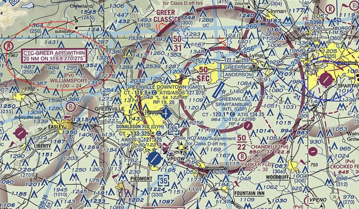
If you’ve ever looked at an aviation sectional chart, you’ve probably noticed circles and lines in different colors.
Class C Airspace is marked by a solid magenta line, which creates a two-tiered ring around the airport it protects.
Here’s how to read it:
The Solid Magenta outlines the boundaries of Class C Airspace. The inner circle represents the 5-nautical mile core, and the outer ring extends to 10 nautical miles.
Inside this magenta boundary, you’ll also see stacked numbers that indicate altitude limits. For example, if you see 40/12:
- The top number (40) means the airspace extends up to 4,000 feet above ground level (AGL).
- The bottom number (12) indicates that the outer shelf starts at 1,200 feet AGL.
2. Digital Airspace Tools to Spot Class C Airspace
If reading sectional charts seems complicated, there are plenty of digital airspace tools that make this process easier, especially for drone pilots.
The FAA’s B4UFLY app is a simple way to check if you’re in controlled airspace. Just enter your location, and it will quickly tell you whether you need FAA approval.
For more advanced features, apps like Aloft and AirMap not only help you identify Class C Airspace but also allow you to request FAA approval instantly through the Low Altitude Authorization and Notification Capability (LAANC) system.
If you prefer a visual representation similar to sectional charts but more user-friendly, SkyVector is a great tool. It displays airspace maps in an interactive format that’s easy to navigate.
Now let’s take a look at how you can legally fly your drone in this airspace.
Requirements for Flying in Class C Airspace
If you’re flying a drone in Class C Airspace, you must get FAA authorization.
The FAA has two main systems for drone pilots to request approval:
1. Use LAANC For Fastest Online Approvals
If your drone flight stays within the FAA’s approved altitude limits (typically 400 feet AGL or lower), you can use LAANC to get instant authorization in most Class C Airspace areas.
LAANC is also accessible through apps like Aloft, Airmap, and Skyward.
Here’s how to do it step by step:
- Open any LAANC-enabled apps
- Enter your flight location to check if you’re in Class C Airspace.
- Select your flight altitude and duration (typically capped at 400 feet AGL or lower).
- Submit the request. If your flight follows FAA rules, you’ll get instant approval.
- Review your authorization details and keep them handy in case of an FAA inspection.
2. For Manual Approvals, Use DroneZone
If your drone flight falls outside LAANC’s automatic approval limits, you’ll need to request for a manual FAA approval.
Here’s how you can request approval through DroneZone:
- Go to the FAA’s DroneZone website.
- Log in or create an account if you don’t have one.
- Submit an airspace authorization request with details about your planned flight.
- Wait for FAA approval—this process can take days to weeks, so plan ahead.
This process typically takes a few days to several weeks, so it’s best to apply well in advance.
3. Why Visibility & Cloud Clearance Matter in Class C Airspace
Imagine you’re flying your drone in Class C Airspace while a commercial flight is approaching for landing.
If the visibility is poor, the pilot may not see your drone before it gets too late.
To prevent this, the FAA requires drone pilots to maintain at least three statute miles of visibility when flying in Class C Airspace.
This means that from your takeoff location, you should be able to see at least three miles ahead in every direction.
This is important because if visibility drops below three miles, the risk of a collision increases significantly.
4. Is Radio Equipment Required for Class C Airspace?
For manned aircraft pilots, Class C Airspace has strict radio equipment requirements to ensure that planes stay in contact with ATC.
The minimum radio equipment required includes:
- Two-Way Radio Communication: To establish communication
- Mode C Transponder: For real-time aircraft position and altitude data
- ADS-B Out (Automatic Dependent Surveillance–Broadcast): Required in some areas for real time tracking.
So why should drone pilots even care about this?
Even though drones don’t need radios or transponders, knowing how manned aircraft operate in Class C Airspace can help you predict their movements in the sky.
Understanding aviation communication can help you anticipate where planes are moving and make safer flight decisions.
Conclusion
Controlled airspace exists for one simple reason: to keep the skies safe and organized.
By now, you know how to identify Class C Airspace, get FAA authorization, follow altitude limits, and anticipate manned aircraft movement.
You’re well on your way to becoming a more responsible and skilled drone pilot.
But knowing the rules is just the beginning. To truly master drone flying, you need hands-on experience, the right tools, and continuous learning.
That’s why we recommend DroneU’s Drone Flying Starter Kit—a must-have for beginners who want to build confidence, improve their flight skills, and learn essential best practices for safe and legal drone operations.
Don’t just fly for fun, fly with confidence!
FAQs
1. Do you need permission to enter Class C Airspace?
Since this is controlled airspace, whether flying recreationally or commercially—you must get FAA authorization before flying a drone in Class C Airspace.
The easiest way to get approval is through LAANC (Low Altitude Authorization and Notification Capability), which provides instant authorization for flights within FAA-approved altitude limits.
If LAANC isn’t available or you need to fly above the approved altitude, you must request manual approval via FAA DroneZone, which can take longer to get approved.
2. Who do you contact to enter Class C Airspace?
Drone pilots don’t contact Air Traffic Control (ATC) directly. Instead, all approvals for flying in Class C Airspace go through the FAA’s online systems.
3. Can I fly my drone in Class C Airspace?
Yes, you can fly your drone in Class C Airspace, but only with FAA approval. Without proper authorization, flying here is illegal and can result in fines or penalties.
The Best LiDAR Drones for Accurate Surveying & Mapping
Did you know that LiDAR technology can capture up to 1 million data points every second?
If you’re involved in surveying, you’ve probably noticed how technology has made a huge leap in recent years.
LiDAR drones are leading the charge, giving professionals a way to gather incredibly accurate data faster than ever before.
LiDAR (Light Detection and Ranging) works by sending out laser pulses and measuring how long it takes for them to bounce back after hitting an object. This creates detailed, precise 3D maps of the area being surveyed.
Here’s what makes drones with LiDAR technology interesting:
- Precision: Capture highly accurate 3D maps.
- Speed: Complete surveys much faster.
- Access: Reach difficult or dangerous areas with ease.
In this guide, we’ll walk you through the best LiDAR drones available based on features and use cases, to help you make the right choice.
Why Choose a LiDAR Drone for Surveying?
LiDAR (Light Detection and Ranging) technology has completely changed the way we approach surveying.
From urban planning to environmental monitoring, it has become an indispensable tool in many industries.
These drones are used for city development, forestry management, or even archaeology.
Here’s how LiDAR drones are transforming industries:
- Speed and Efficiency: Cover large areas quickly, saving time compared to traditional methods.
- Unmatched Accuracy: Collect high-resolution data, even in tough terrain.
- Vegetation Penetration: Get ground-level data beneath thick vegetation—something other methods struggle with.
- Cost-Effectiveness: Reduce the need for labor-intensive work and expensive equipment, leading to a better ROI.
Factors to Consider When Selecting a LiDAR Drone
Choosing the right LiDAR drone for your project can be a game-changer. To make sure you invest wisely, here are the key factors you should consider:
- Flight Endurance: Longer flight times are crucial for covering large areas without needing frequent recharges. This is especially important for extensive surveys.
- Payload Capacity: Make sure the drone can carry the LiDAR sensor you need. Heavier sensors provide more detailed data, but they also require drones with a higher payload capacity.
- Data Accuracy: High-resolution data and dense point clouds are essential for creating detailed and reliable maps. Don’t compromise on accuracy.
- Ease of Use: Look for drones with intuitive software and seamless hardware integration. The easier it is to operate, the more time you’ll save on each project.
- Cost vs. Features: Balancing your budget with the features and performance you need is key. While it’s tempting to opt for the most advanced drone, it’s important to evaluate whether you truly need those extra features for your specific use case.
When selecting your LiDAR drone, it’s important to assess your unique project needs and find a model that fits both your technical requirements and budget.
Top LiDAR Drones for Surveying
Finding the right LiDAR drone can be overwhelming, but we did the grunt work for you.
We have identified some of the best models available today, categorized by their strengths. A few newer and noteworthy models are also provided so you can have more variety in the selection process.
1. AgEagle eBee X
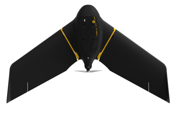
The AgEagle eBee X is a lightweight, high-performance fixed-wing drone designed for professional-grade mapping and surveying.
With up to 90 minutes of flight time and exceptional endurance, this drone is an ideal choice for large-area surveys, including LiDAR mapping.
It is equipped with RTK (Real-Time Kinematic) and PPK (Post-Processed Kinematic), and the eBee X delivers highly accurate georeferencing without the need for ground control points.
It is fully compatible with various LiDAR sensors, enabling it to handle high-precision surveying tasks across industries like agriculture, forestry, and infrastructure.
Key Features:
- Flight Time: Up to 90 minutes of flight time, allowing for extensive coverage in a single flight.
- RTK & PPK: Provides highly accurate data collection, ensuring precise mapping without the need for ground control points.
- Interchangeable Cameras: Compatible with a wide range of photogrammetry cameras, providing flexibility for different mapping applications.
- eMotion Flight Planning Software: The drone is powered by eMotion, AgEagle’s user-friendly flight planning software, simplifying mission planning and data capture.
- Safety Features: Designed to operate safely over people and Beyond Visual Line of Sight (BVLOS), compliant with NDAA standards.
- Compatibility: Works with industry-leading base stations to ensure reliable, high-quality data.
- Lightweight Design: Its lightweight build makes it easy to transport and deploy in the field.
Pros:
- Long Flight Time: With 90 minutes of endurance, it can cover large areas in one flight, increasing efficiency and reducing operational costs.
- Precision: RTK and PPK systems provide high-accuracy data without the need for ground control points, making it ideal for large-scale, high-precision surveys.
- Versatility: The eBee X is compatible with multiple sensors and cameras, including LiDAR systems, offering flexibility for various survey needs.
- Safety and Compliance: Its ability to fly safely over people and BVLOS (Beyond Visual Line of Sight) makes it suitable for complex, large-area surveys in populated or difficult-to-access areas.
- User-Friendly: The eMotion flight planning software simplifies setup and mission planning, even for users with limited drone experience.
Cons:
- Price: As a high-end, professional-grade drone, the eBee X can be quite expensive, particularly when equipped with advanced payloads like LiDAR sensors.
- Fixed-Wing Design: While fixed-wing drones offer longer flight times, they may not be as maneuverable or suitable for smaller, confined areas compared to multirotor drones.
- Learning Curve: Although it is user-friendly, mastering advanced features like LiDAR data processing and RTK/PPK workflows may require additional training.
2. Phantom 4 RTK
The DJI Phantom 4 RTK is a robust, ready-to-fly drone equipped with RTK technology to ensure centimeter-level accuracy in mapping. This drone is designed for precise photogrammetry applications and is highly compatible with various LiDAR payloads.
It is a great option for surveyors who require high-precision data in areas such as topography, infrastructure, and construction.
While the Phantom 4 RTK’s primary function is photogrammetry, it also supports LiDAR sensors. The RTK technology ensures high precision, making it a great candidate for small to medium-sized surveying projects.
Key Features:
- RTK Technology: Provides centimeter-level accuracy, ideal for precise mapping and surveying without the need for ground control points.
- High-Resolution Camera: 20 MP, 1-inch CMOS sensor for high-quality aerial imagery.
- Integrated GNSS Module: The RTK module ensures real-time correction of GPS data, improving accuracy and consistency during flights.
- Advanced Flight Autonomy: The drone features multiple sensors, including forward and downward vision systems, for safer flight and obstacle avoidance.
- 3D Mapping Compatibility: Compatible with LiDAR payloads, making it suitable for generating 3D models and performing high-accuracy mapping.
- Long Flight Time: Up to 30 minutes of flight time, depending on payload and flight conditions.
- Compact Design: Portable and lightweight, making it easy to transport to various survey sites.
- Smart Flight Modes: Includes features like Waypoints, Point of Interest (POI), and Follow Me, making it easier to plan missions for mapping or surveying.
Pros:
- Centimeter-Level Accuracy: The RTK technology ensures high precision in data collection, essential for accurate LiDAR surveying.
- Photogrammetry and LiDAR Compatibility: While designed for photogrammetry, the Phantom 4 RTK is fully compatible with LiDAR sensors, offering versatility for different surveying needs.
- Compact and Portable: The lightweight, foldable design makes it easy to transport, ideal for fieldwork in various environments.
- Long Flight Time: Up to 30 minutes of flight time allows for efficient surveying of larger areas without frequent recharging.
- User-Friendly: DJI’s software and flight controller makes the Phantom 4 RTK easy to set up, fly, and operate, even for those new to drone surveying.
- Obstacle Avoidance: Equipped with forward and downward sensors, it enhances flight safety and reduces the risk of collisions during flight.
Cons:
- Payload Capacity: While capable of carrying some LiDAR sensors, the Phantom 4 RTK has a limited payload capacity compared to larger drones, which may limit the size and type of LiDAR sensor it can carry.
- Limited Range: The maximum transmission range of around 7 km may not be suitable for very large or remote surveying tasks.
- No Built-in LiDAR: The Phantom 4 RTK doesn’t come with a LiDAR sensor, meaning users will need to purchase a LiDAR payload separately.
- Price: The Phantom 4 RTK, while affordable compared to larger commercial drones, is still an investment, especially when adding additional LiDAR sensors.
3. Freefly Alta X
The Freefly Alta X is an excellent choice for LiDAR surveying, particularly for professional surveyors working on large or complex projects. With the ability to carry large, high-end LiDAR sensors, the Alta X offers exceptional flexibility and reliability.
It features a foldable design for easy transport and a quick-release system for effortless payload changes. Its 30-minute flight time and support for professional-grade sensors is ideal for surveying and mapping in industries like construction, agriculture, mining, and forestry.
Moreover, the powerful payload capacity, long flight time, and robust design makes it a top-tier solution for high-precision mapping and data collection.
Key Features:
- High Payload Capacity: Can carry a wide range of LiDAR sensors, including those originally designed for full-size helicopters.
- 30-Minute Flight Time: Offers long endurance, allowing for larger survey areas to be covered in a single flight.
- Foldable Design: Easily collapses to half its normal size, making it portable and convenient for fieldwork.
- Quick-Release System: Allows for fast and easy installation or swapping of LiDAR sensors and other payloads.
- Auterion Enterprise PX4: Supports the Auterion Enterprise PX4 flight control system, providing a reliable and flexible software platform.
- MAVSDK Compatibility: Fully supports MAVSDK, offering more advanced automation and integration for various surveying applications.
- Professional-grade LiDAR Support: Built to carry the best LiDAR sensors available, ensuring top-quality data collection.
Pros:
- High Payload Flexibility: The Alta X can carry a variety of LiDAR sensors, making it ideal for large-scale surveying tasks that require powerful equipment.
- Long Endurance: With a flight time of up to 30 minutes, it offers sufficient time to survey larger areas without needing to land for recharging.
- Easy Transport: Its foldable design reduces the drone’s footprint, making it easier to transport between job sites.
- Robust and Reliable: Designed for demanding professional use, the Alta X is built to endure tough conditions, making it suitable for diverse environments.
- Advanced Software: The integration with Auterion Enterprise PX4 and MAVSDK provides flexibility for custom missions and automation, enhancing the drone’s functionality for precise LiDAR surveying.
- Fast Payload Changes: The quick-release system enables quick adjustments to different sensors, reducing downtime between missions.
Cons:
- Higher Cost: The Alta X is a premium drone, and its price may be prohibitive for smaller businesses or individuals just starting with LiDAR surveying.
- Size and Weight: While the drone is foldable for transport, it’s still a relatively large and heavy platform, which may limit its use in tighter or more restricted areas.
- Not Beginner-Friendly: Due to its advanced features and payload capabilities, the Alta X may require more experienced drone operators for optimal performance.
- Battery Life: While 30 minutes of flight time is impressive, larger LiDAR sensors or demanding tasks might reduce endurance, necessitating additional batteries.
4. Matrice 350 RTK

The DJI Matrice 350 RTK is a next-generation drone designed to elevate professional operations in aerial surveying and mapping.
Equipped with RTK technology, it provides centimeter-level accuracy for LiDAR data collection, making it ideal for applications requiring high-precision geospatial data.
The DJI Matrice 350 RTK is an exceptional choice for LiDAR surveying due to its high accuracy, long flight time, and ability to carry a wide range of payloads, including LiDAR sensors. Its advanced features, including the RTK technology, weather resistance, and multi-payload support, make it well-suited for large-scale, professional surveying projects.
Key Features:
- 55-Minute Maximum Flight Time: Extended flight time, allowing for longer surveying sessions and coverage of larger areas.
- RTK Technology: Provides centimeter-level accuracy for high-precision data collection, especially beneficial for LiDAR surveying.
- IP55 Rating: Weather-resistant design ensures reliable operation in various environmental conditions, including dust and rain.
- DJI O3 Enterprise Transmission: Delivers high-quality, long-range video and control transmission, enhancing mission efficiency and safety.
- Multi-Payload Support: Capable of carrying various payloads, including LiDAR sensors, cameras, and other surveying tools, making it highly versatile for different surveying needs.
- 6-Directional Sensing & Positioning: Advanced sensors ensure safer flight operations, including obstacle avoidance in all directions.
- Night-Vision FPV Camera: Provides improved visibility during low-light conditions, enhancing safety and precision.
- DJI RC Plus Controller: Offers a more intuitive and responsive control experience for smooth flight operations.
- DJI Pilot 2 App: Optimized app for mission planning and real-time monitoring, ensuring a smooth and efficient operation.
Pros:
- Long Flight Time: With up to 55 minutes of flight time, the Matrice 350 RTK is highly efficient for large-area surveying, reducing the need for frequent battery swaps.
- Centimeter-Level Accuracy: RTK technology ensures that LiDAR data is collected with high precision, making it suitable for projects requiring detailed mapping.
- Weather Resistance: IP55 rating ensures reliable operation in various weather conditions, providing flexibility in diverse environments.
- Advanced Safety Features: With 6-directional sensing and positioning, the drone offers enhanced obstacle avoidance and more reliable flight, reducing the chances of mishaps during operations.
- Multi-Payload Capability: Its ability to carry multiple payloads, including LiDAR sensors, cameras, and thermal imaging devices, enhances its utility for a wide range of surveying applications.
- Improved Transmission System: The DJI O3 Enterprise Transmission ensures excellent video and control signal stability, even in long-range operations.
Cons:
- High Cost: As a professional-grade drone with advanced capabilities, the Matrice 350 RTK comes with a high price tag, which may be a barrier for smaller businesses or individual operators.
- Complexity: Due to its advanced features and payload capabilities, the drone may require experienced operators to maximize its potential and ensure safe, effective missions.
- Heavy: The drone is relatively large and may not be as portable as smaller drones, which could pose challenges when transporting it between job sites.
- LiDAR Sensor Not Included: While the Matrice 350 RTK can carry LiDAR sensors, it does not come with a built-in LiDAR system, so you would need to purchase the sensor separately.
5. Flyability Elios 3
The Flyability Elios 3 is a highly capable drone for LiDAR mapping and inspections in confined indoor environments.
It integrates LiDAR technology with FlyAware™ computer vision to offer real-time 3D mapping.
This advanced technology makes a good choice for confined space inspections and asset management in industries like oil & gas, utilities, and manufacturing.
Featuring SLAM-based stabilization, the Elios 3 maintains exceptional control and stability, even in complex indoor environments.
The best part? It requires minimal training for drone operators.
If your LiDAR surveying projects focus on detailed inspections within industrial facilities or other hard-to-reach locations, the Elios 3’s advanced SLAM-based stabilization, modular payload options, and collision-resilient design make it an excellent choice.
However, it is not suitable for traditional large-scale outdoor LiDAR surveying tasks.
Key Features:
- FlyAware™ SLAM Engine: Uses LiDAR technology and computer vision to build real-time 3D maps with centimeter-level accuracy, enabling precise indoor navigation.
- 3D Reporting: Creates accurate 3D models for reporting and analysis, streamlining asset management and inspection workflows.
- Collision-Resilient Design: Built to withstand bumps and collisions, ensuring safe operation in tight or cluttered spaces.
- SLAM-Based Stabilization: Ensures the drone remains stable even in turbulent or unpredictable environments, enabling precise data collection.
- Modular Payload Bay: Offers flexibility to switch between various payloads, including LiDAR and other sensors.
- Close-Up Inspection Payload: Designed for detailed inspections in hard-to-reach areas, enhancing the drone’s versatility.
- 3D Live Map: Real-time mapping capabilities for immediate situational awareness.
- Return-to-Signal: Ensures the drone can return to its starting point in case of signal loss, improving safety during missions.
- Extended Air-Time: Provides enough flight time for extended inspections in large indoor spaces.
Pros:
- Ideal for Confined Spaces: Perfect for performing LiDAR mapping and inspections in indoor or restricted environments that are difficult for other drones to access.
- Highly Accurate 3D Mapping: With FlyAware™ and SLAM-based stabilization, it offers high-precision, real-time 3D mapping and asset management in complex environments.
- User-Friendly: Designed to be accessible to operators with varying skill levels, requiring little to no prior drone experience for successful missions.
- Durable and Collision-Resilient: The drone’s rugged design allows it to withstand the harsh conditions of indoor inspections, providing added durability and safety.
- Flexible Payload Options: The modular payload bay allows for easy switching between different sensors and tools, including LiDAR systems, enhancing its versatility.
- Real-Time 3D Mapping: Enables immediate reporting and situational awareness with the live 3D map feature, making it easier to make decisions during operations.
Cons:
- Limited to Indoor Use: The Elios 3 is designed primarily for indoor mapping and inspection and is not suitable for large-scale outdoor LiDAR surveying.
- Higher Cost for Niche Use: While the drone excels in its specialized domain, it may not be the most cost-effective solution for outdoor LiDAR applications due to its specific use case.
- Shorter Range and Flight Time: Compared to other outdoor drones, the Elios 3 may have a shorter flight time and range, making it less suitable for large-area surveying tasks.
- Requires Precise Handling in Tight Spaces: Although it’s user-friendly, the confined space nature of many missions can still pose challenges, requiring extra caution during operation.
6. Microdrones mdLiDAR1000
The Microdrones mdLiDAR1000 is a robust and all-in-one drone solution for LiDAR surveying and geospatial data collection. It provides high-accuracy results and is particularly suited for mining, construction, forestry, and other industries requiring reliable 3D point clouds.
It integrates a LiDAR payload with a drone and advanced software to offer an end-to-end workflow.
The system is known for producing high-quality 3D point clouds with consistent accuracy of 6 cm (0.2 ft), making it an ideal choice for professionals seeking to conduct precise mapping tasks in various challenging environments.
Key Features:
- High-Accuracy LiDAR System: Provides a consistent accuracy of 6 cm (0.2 ft) when flown at 40 meters (130 feet) at speeds up to 3 m/s (6.7 mph), delivering reliable data for high-precision surveys.
- Fully Integrated Solution: Includes a drone, LiDAR payload, and mdInfinity software, creating a seamless workflow for 3D point cloud generation and geospatial analysis.
- Versatile Applications: Suitable for corridor mapping, mining volume calculations, construction site monitoring, forestry, environmental monitoring, and more.
- Optimized for Geospatial Productivity: The system combines LiDAR with mdaaS for ease of use and enhanced productivity in data collection and analysis.
- End-to-End Workflow: The integration of hardware, software, and support ensures a consistent, high-quality surveying process from data collection to deliverables.
- Durable and Reliable: Built to withstand rigorous field conditions, making it suitable for a range of outdoor applications.
Pros:
- High Precision: Offers 6 cm accuracy, ensuring that LiDAR data is highly accurate and reliable, crucial for tasks like corridor mapping, volume calculations, and environmental assessments.
- All-in-One System: The integration of the drone, LiDAR payload, and software streamlines operations, minimizing the need for third-party tools or additional configurations.
- Versatile for Multiple Applications: Whether you’re working in mining, construction, forestry, or archaeology, the mdLiDAR1000 adapts to various industries, providing consistent results for diverse surveying tasks.
- Ease of Use: With the mdInfinity software and the mdaaS system, the workflow is optimized for ease of use, reducing the learning curve and increasing operational efficiency.
- Reliable Performance: The drone provides consistent performance with an accuracy of 6 cm, making it a dependable choice for geospatial professionals working in the field.
- Comprehensive Support: Microdrones offers world-class support, ensuring that users have access to the help they need to resolve any issues or questions during data collection and processing.
Cons:
- Higher Cost: The mdLiDAR1000 system may be relatively expensive, particularly for smaller businesses or individuals just starting in LiDAR surveying.
- Requires Professional Expertise: While the system is user-friendly, the complexity of LiDAR surveys may still require professional expertise in both drone operation and data processing.
- Limited to Specific Applications: While versatile, the mdLiDAR1000 is best suited for tasks like mining, construction, and forestry; it may not be the most efficient choice for applications outside of these fields, especially in areas requiring specialized sensors or higher-level customization.
- Requires Integration with Software: The system relies on the mdInfinity software, which means users must be comfortable with this specific software package for managing and processing data.
7. Harris Aerial H6 Hybrid
The Harris Aerial H6 Hybrid is a high-endurance hexacopter that is specifically built for LiDAR surveying and other demanding surveying tasks.
With its long flight time, high payload capacity, and versatile power formats, it is well-suited for professionals who require a drone capable of covering extensive areas while carrying high-performance LiDAR sensors and other surveying equipment.
Additionally, its convertible power formats allow users to switch between gasoline-electric, hydrogen-electric, and fully electric configurations, providing unmatched versatility in mission planning.
Key Features:
- Long-Endurance Flight: Capable of flying for up to 2.5 hours with a 5 kg payload, allowing for extended mapping sessions without the need for frequent recharging or refueling.
- Versatile Power Formats: Can be converted between gasoline-electric, hydrogen-electric, and fully electric configurations, allowing flexibility to adapt to various mission requirements.
- High Payload Capacity: Supports a wide range of high-end LiDAR sensors, DSLR cameras, and other surveying equipment, making it suitable for collecting high-resolution point clouds and orthomosaics.
- Compatibility with Top Sensors: Fully compatible with the best LiDAR sensors available, delivering industry-leading results in LiDAR surveying and photogrammetry.
- Robust for Large Area & Corridor Mapping: The drone’s extended flight duration and high payload capacity make it ideal for large area mapping and large corridor surveys, providing detailed geospatial data over vast distances.
- Adaptable for Various Applications: In addition to LiDAR surveying, the H6 Hybrid is popular for utility inspections, surveillance, and photogrammetry, providing versatility for different types of aerial data collection.
Pros:
- Impressive Flight Time: The H6 Hybrid offers up to 2.5 hours of flight time with a 5 kg payload, allowing for long-duration surveying without constant recharging or changing batteries.
- Multiple Power Options: The ability to switch between gasoline-electric, hydrogen-electric, and fully electric configurations provides flexibility for mission planning, ensuring optimal performance in various conditions.
- High Payload Capacity: Supports a broad range of payloads, including LiDAR sensors and DSLR cameras, making it highly versatile for different types of geospatial data collection.
- High-Resolution Data Collection: Compatible with high-quality LiDAR and photogrammetry sensors, enabling the collection of detailed point clouds and orthomosaics for accurate mapping and analysis.
- Ideal for Large Surveys: The H6 Hybrid is especially well-suited for large area surveys and corridor mapping due to its endurance, stability, and ability to carry heavy, high-performance payloads.
- Flexible and Adaptable: The drone’s ability to convert between power formats makes it adaptable to a wide variety of operational environments and mission types.
Cons:
- Higher Initial Cost: Due to its specialized design and versatility, the H6 Hybrid may come with a higher initial investment, which could be a consideration for smaller operations or those just starting in LiDAR surveying.
- Complex Maintenance: With its hybrid power system and multiple power configurations, the H6 Hybrid may require more maintenance and technical expertise to ensure smooth operation and conversion between power formats.
- Large Size and Weight: While its size and weight contribute to its ability to carry heavy payloads, they also make it less suitable for smaller or more confined operational environments compared to smaller drones.
- Limited Availability of Spare Parts: As with any specialized drone system, users may face challenges in obtaining spare parts quickly in case of emergencies, although Harris Aerial does offer direct sales of parts.
Comparison Table of Top LiDAR Drones
| Drone Model | Flight Time | Payload Capacity | Key Features | Best For |
| AgEagle eBee X | Up to 90 minutes | 1.2 kg (2.6 lbs) | RTK, PPK, interchangeable photogrammetry cameras, eMotion software | Large area mapping, Forestry, Archaeology, Environmental monitoring |
| Phantom 4 RTK | Up to 30 minutes | 1 kg (2.2 lbs) | RTK for enhanced georeferencing, 1-inch 20MP camera, advanced flight modes | Small to medium-scale surveys, Agriculture, Construction |
| Freefly Alta X | Up to 50 minutes | 15 kg (33 lbs) | Heavy-lift capabilities, customizable payload options, rugged design | Large area surveys, Mining, Utility inspections, Film production |
| Matrice 350 RTK | Up to 55 minutes | 2.7 kg (6 lbs) | RTK, multi-payload support, advanced sensors, DJI Pilot 2 app, 6-directional sensing | Large-scale surveys, Infrastructure, Mining, Utilities |
| Flyability Elios 3 | Up to 25 minutes | 1.5 kg (3.3 lbs) | LiDAR + computer vision, SLAM stabilization, modular payload, indoor mapping | Indoor inspections, Complex confined spaces, Industrial Surveying |
| Microdrones mdLiDAR1000 | Up to 45 minutes | 3.6 kg (8 lbs) | Fully integrated LiDAR system, mdInfinity software, 3D point clouds, easy-to-use | Mining, Construction, Highway mapping, Forestry, Archaeology |
| Harris Aerial H6 Hybrid | Up to 2.5 hours | 5 kg (11 lbs) | Hybrid power system, long endurance, customizable payloads, convertible formats | Large area surveys, Corridor mapping, Utility inspections |
Real-World Use Cases for LiDAR Drones
LiDAR drones are making waves across various industries by solving complex challenges and improving efficiency. Here are a few real-world examples:
1. Urban Development: Mapping for City Planning and Infrastructure
LiDAR drones are essential for urban development, especially when it comes to mapping and city planning. In one major U.S. city, LiDAR drones were used to optimize traffic flow and redesign urban layouts, helping reduce congestion by 25%.
2. Forestry and Environmental Studies: Monitoring Forest Health
In Canada, LiDAR drones played a crucial role in mapping tree canopies and assessing the effects of logging. This helped forestry experts preserve endangered species by providing detailed insights into forest health and tree density.
3. Archaeological Surveys: Uncovering Hidden Structures
LiDAR drones are helping archaeologists explore dense forests and uncover ancient ruins. In Central America, a project revealed over 60,000 previously unknown Mayan structures, changing how we understand ancient civilizations.
4. Power Line Inspections: Enhancing Safety and Efficiency
In Europe, a utility company used LiDAR drones to inspect over 1,000 miles of power lines, reducing manual inspection time by 40%. This not only saved time but also improved safety, as drones could access hard-to-reach areas more easily than human crews.
Each of these examples shows how LiDAR drones are making an impact across industries, enhancing both efficiency and precision.
Conclusion
Choosing the right LiDAR drone for your surveying projects ultimately depends on your specific needs and the scale of your operations.
If you’re tackling large-scale projects and need long flight times with high payload capacity, the AgEagle eBee X, Freefly Alta X, Matrice 350 RTK, and Harris Aerial H6 Hybrid are excellent options, each offering robust performance for extensive surveys.
For those focused on precision and smaller-scale surveys, the Phantom 4 RTK provides an affordable and compact solution, ideal for smaller to medium-sized projects, though its payload capacity limits it for heavier LiDAR sensors.
If your work involves indoor inspections or navigating complex, confined spaces, the Flyability Elios 3 is the top choice, offering unparalleled stability and ease of use in tough environments, though with a shorter flight time.
Lastly, the Microdrones mdLiDAR1000 excels as an integrated system, combining a drone with LiDAR payload and processing software to deliver seamless results for those seeking an all-in-one solution for corridor mapping, mining, and other geospatial tasks.
Ultimately, understanding the unique needs of your surveying tasks will guide you in selecting the best drone that aligns with your goals, whether it’s large-scale coverage, precision, or specialized applications.
Frequently Asked Questions (FAQs)
1. Which LiDAR drone is best for beginners?
The DJI Matrice 300 RTK with Zenmuse L1 is a great option for beginners. It offers advanced automation features and intuitive controls, making it easier to operate for those new to LiDAR technology.
2. How much does a LiDAR drone cost?
Prices can vary widely. Typically, they range from $30,000 to $100,000+, depending on the drone model and sensor configuration you choose.
3. What is the average flight time for LiDAR drones?
Most LiDAR drones offer flight times between 30 and 55 minutes, depending on the drone’s payload capacity and environmental factors.
4. Do I need special training to operate a LiDAR drone?
While basic drone piloting skills are essential, additional training in LiDAR data processing is highly recommended to leverage the capabilities of the technology fully.
5. Can LiDAR drones work in poor weather conditions?
Some models, like the DJI Matrice 300 RTK, offer weather resistance (IP45-rated), but extreme weather conditions like heavy rain or high winds can still affect performance. It’s best to avoid flying in severe weather.
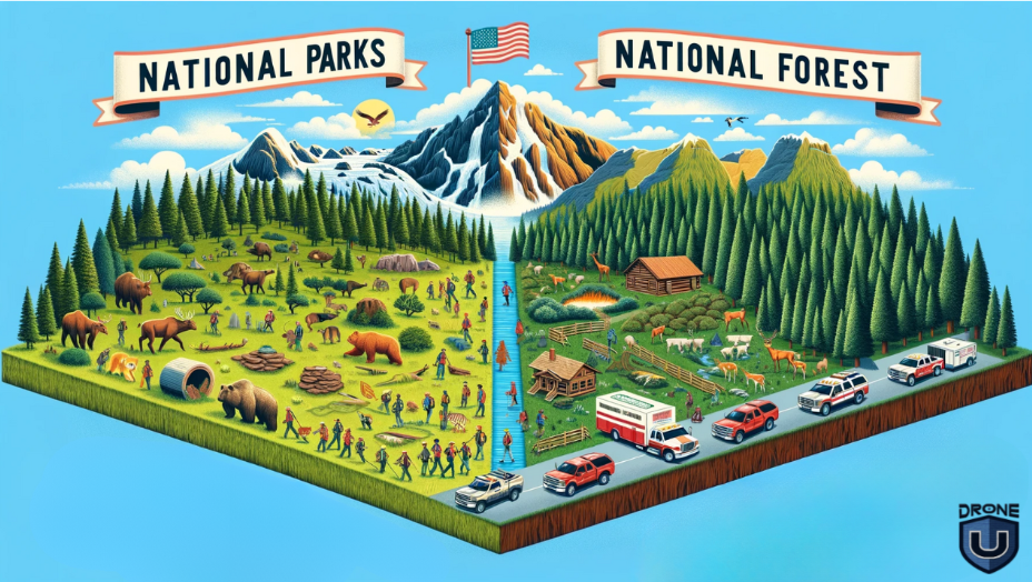
Flying Drones in National Parks and National Forests: Updated Guidelines
Operating drones in the United States requires adherence to specific regulations, particularly within National Parks and National Forests. Understanding these rules is essential for responsible drone use.
With recent legislative updates and ongoing changes in park policies, drone enthusiasts must stay informed to avoid violations.
In this article, we will share the most updated information on rules for flying drones in National parks and forests.
National Parks: Drone Use and New Filming Rules

The National Park Service (NPS) prohibits the use of drones within all National Parks. This ban, established in 2014, aims to protect wildlife, ensure visitor safety, and preserve the natural ambiance. Violations can result in fines and confiscation of equipment.
Recent legislative changes have eased restrictions on photography and filming in National Parks. The FILM Act, signed into law in January 2025, allows small groups (fewer than six individuals) to engage in filming activities without obtaining a permit, provided they comply with park regulations and do not disrupt park resources or visitor experiences.
Check out the video to learn about getting the permit to fly drones in a national park
However, this legislative change does not affect the prohibition of drone use. The ban on drones remains in place to protect park resources and visitor experiences.
Additionally, you may use UAS for scientific studies in certain units of the National Park Service. To do so, consult the NPS Park Aviation Manager (PAM) and park research coordinators to ensure you meet all UAS and related requirements. If needed, follow up with the Regional Aviation Manager (RAM).
Additional Park Restrictions
Some parks are introducing new measures to manage visitor impact. For instance:
- Canyon de Chelly in Arizona will soon ban commercial air tours, including any drone-related activities, to maintain the area’s tranquility and cultural significance.
- Five more National Parks have implemented reservation systems in 2025 to control overcrowding and protect natural resources. Drone operators and other visitors must plan their trips carefully to comply with these new rules.
National Forests: Opportunities and Restrictions
In contrast to National Parks, drone use in National Forests is generally permitted, subject to specific guidelines:
- Wilderness Areas: Drones are prohibited in Congressionally designated Wilderness Areas to maintain their pristine conditions.
- Temporary Restrictions: Certain areas may have temporary flight restrictions due to events like wildfires or wildlife nesting seasons.
- Local Regulations: Some National Forests may have additional rules or require permits for drone operations.
For the most current and detailed information, it’s advisable to consult directly with the U.S. Forest Service or visit their official website.
How These Rules Differ From Those In National Parks
The rules for drone use in National Parks and National Forests in the United States differ significantly due to the differing management goals and policies of the National Park Service (NPS) and the U.S. Forest Service (USFS).
Here’s a comparison of how the rules vary:
National Parks (Managed by NPS)
- General Prohibition: The NPS generally prohibits the launching, landing, and operation of drones within the boundaries of National Parks. This ban is aimed at protecting wildlife, and visitor experiences, and preserving the natural soundscape.
- Special Permits Required: Drone use is typically only allowed with special permits, and these are usually granted for scientific research, resource management, or other administrative purposes.
- Strict Enforcement: Violation of drone regulations in National Parks can lead to significant penalties, including fines and legal action.
- Focus on Preservation: The NPS’s strict stance on drones is largely driven by its mandate to preserve natural and cultural resources and to provide unimpaired enjoyment of these resources for future generations.
National Forests (Managed by USFS)
- More Lenient Rules: The USFS generally allows the use of drones in National Forests, but operators must follow Federal Aviation Administration (FAA) regulations and USFS guidelines.
- Restrictions in Specific Areas: Drone use may be restricted in certain areas, particularly near wildfires or in designated wilderness areas where the use of motorized equipment is prohibited.
- Consideration for Wildlife and Environment: While drone use is permitted, pilots are advised to avoid disturbing wildlife and sensitive habitats.
- Commercial Use: For commercial drone operations or specific drone activities beyond recreational use, a special use authorization from the USFS may be required.
Key Differences
- General Policy: The NPS adopts a more restrictive approach due to its focus on preservation, whereas the USFS provides more flexibility, reflecting its multiple-use mandate which includes recreation, conservation, and resource management.
- Enforcement and Penalties: The potential consequences for unauthorized drone use are generally more severe in National Parks compared to National Forests.
- Area Restrictions: National Parks have a broader prohibition, while National Forests have more specific restrictions related to certain areas or activities.
Tips For Safe Drone Operation In Sensitive Areas
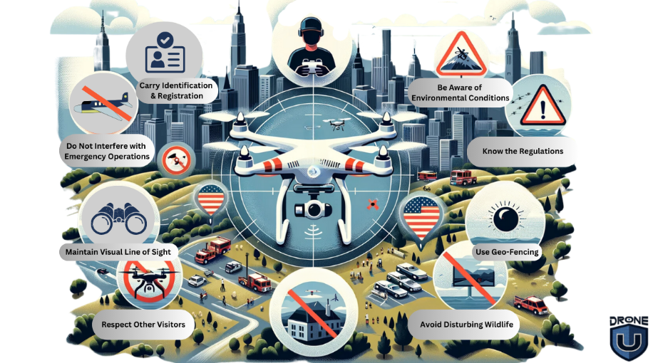
Operating drones in sensitive areas like National Parks and National Forests requires careful consideration and adherence to specific safety guidelines to ensure both the protection of the environment and the enjoyment and safety of other visitors.
Here are some tips for safe drone operation in these areas:
1. Know the Regulations
Before flying a drone, be aware of and understand the specific regulations of the area you’re in. National Parks generally prohibit drone use, while National Forests have more lenient rules but with certain restrictions.
It’s important to note that each National Park operates as its own entity, so regulations and permitting processes can vary.
Though they share a general prohibition on drone use, any permit requests should be directed to the specific park you’re planning to visit.
Check out the National Park Service website for specific rules about flying in a National Park and contact the Park directly if you need a permit.
2. Avoid Disturbing Wildlife
Drones can stress or scare wildlife, leading to negative impacts on their natural behavior and habitat. Keep a safe and respectful distance from animals.
3. Respect Other Visitors
Be mindful of other people’s experiences in these natural settings. Avoid flying drones near other visitors, especially in quiet areas where people seek solitude and peace.
4. Maintain Visual Line of Sight
Always keep your drone within your line of sight. This is the law and helps in avoiding unintended interactions with wildlife, people, or other aircraft.
5. Aware of Environmental Conditions
Weather conditions can change rapidly in outdoor settings. Be aware of wind, temperature, and other environmental factors that can affect drone operation.
6. Use Geo-Fencing If Available
Some drones come with geo-fencing capabilities that can help prevent them from entering restricted areas. Make use of these features to stay compliant with area regulations.
7. Do Not Interfere with Emergency Operations
Never fly a drone near emergency response efforts, such as firefighting or search and rescue operations. Drones can severely hamper any efforts with these critical activities.
8. Carry Identification and Registration
Have your drone registration and identification on hand in case you are approached by authorities or other individuals questioning your drone use.
These guidelines provide a general overview, but it’s always best to consult directly with the relevant authorities or their websites for the most accurate and up-to-date information.
For best practices shared by the NPS, check out this link.
Conclusion
While recent legislative changes have made it easier for photographers and filmmakers to operate in National Parks without permits, the prohibition on drone use remains unchanged.
In National Forests, drone use is generally allowed, but it’s essential to follow specific guidelines and respect any local restrictions.
Additionally, with new restrictions such as reservation systems and air tour bans in certain parks, drone operators should plan and remain vigilant about evolving policies.
Staying informed and practicing responsible drone use will help ensure compliance and preserve the beauty of these treasured landscapes.

Drone Light Shows: Everything You Need to Know
Imagine looking up at the night sky and seeing thousands of drones dancing in perfect harmony forming dazzling shapes, colors, and animations.
It’s more than just a spectacle.
It’s a mesmerizing blend of art and cutting-edge technology that leaves the audience in awe.
Well, this is drone technology, pushing the boundaries of entertainment.
Drone light shows are taking the world by storm. They are revolutionizing entertainment and redefining what’s possible in the skies.
Have you ever wondered how these mesmerizing displays come to life? Or why major events, global brands, and even private celebrations are embracing this innovative technology?
Let’s dive into the fascinating world of drone light shows.
What Are Drone Light Shows?

Drone light shows are synchronized aerial performances. Fleets of drones equipped with LED lights create breathtaking visual displays.
Advanced software controls these drones, forming intricate patterns, animations, and even words. The precision and artistry captivate audiences worldwide.
Unlike traditional fireworks, drone light shows are eco-friendly and safer. They also offer endless creative possibilities.
From illuminating the night sky at concerts to telling powerful stories during social campaigns, these shows blend technology and art seamlessly.
Brief Timeline of Drone Light Shows

- 2012: The concept of drone light shows emerges with advancements in drone technology.
- 2015: Intel sets a Guinness World Record with a 100-drone performance in Germany.
- 2018: Drone light shows gain global attention during the Winter Olympics in PyeongChang.
- 2021-Present: Widespread adoption for events, marketing campaigns, and celebrations worldwide.
Applications of Drone Light Shows

Drone light shows have revolutionized the way we create visual spectacles, offering innovative and captivating displays for various occasions.
Here are some popular applications:
1. Events
From weddings to large-scale festivals, drone light shows bring a captivating blend of technology and artistry. These synchronized displays create awe-inspiring visuals, transforming ordinary events into unforgettable memories.
- Festivals: Transform music festivals into unforgettable experiences.
- Concerts: Elevate performances with synchronized aerial visuals.
- Sports Events: Celebrate milestones or opening ceremonies with grandeur.
2. Marketing
Imagine your brand’s logo illuminated in the night sky or a product launch accompanied by a choreographed aerial performance. Drone light shows redefine advertising by offering a bold and innovative way to connect with audiences and leave a lasting impression.
- Product Launches: Companies like Intel and Hyundai have used drone light shows to unveil products with a bang.
- Brand Promotions: Create viral moments that resonate with audiences.
3. Social Causes
Sometimes, you need more than just words to make an impact. Drone light shows turn powerful messages into stunning visuals that grab attention and stick with people. You can combine storytelling with artistry to ensure your cause resonates deeply with audiences.
- Awareness Campaigns: Use visual storytelling to highlight climate change and equality issues.
4. Personal Celebrations
Big moments deserve big gestures. From personalized messages to intricate designs, you can do it all with a custom drone light show. Birthdays, anniversaries, and weddings can be truly memorable with these performances.
- Weddings: Add a magical touch to wedding nights.
- Private Parties: Make milestones unforgettable with custom displays.
How Does a Drone Light Show Work?

Ever wondered what goes into creating those jaw-dropping drone light shows? It’s not just a bunch of drones flying around randomly. It’s a carefully orchestrated masterpiece that combines cutting-edge technology, creativity, and precision.
Let’s take a peek behind the scenes to see how it all comes together.
1. The Vision
First, it all starts with a vision. Whether it’s a company logo, a story, or a stunning pattern, the creative team designs the show using specialized software. This software maps out every drone’s position and movement, ensuring the visuals are perfectly synchronized. Think of it like choreographing a dance but in the sky!
2. Programming Phase
Each drone is pre-loaded with its flight path and timing. These drones are equipped with GPS, sensors, and LED lights, allowing them to follow their paths with pinpoint accuracy. The software ensures that every drone knows exactly where to go and when to light up, avoiding mid-air collisions.
3. Testing
On the big day, the setup is crucial. A large open area is chosen as the launch site, where all the drones are carefully arranged and tested. Technicians double-check everything—from battery levels to communication signals—to make sure nothing goes wrong during the show.
4. The Final Show
Then, the magic happens. With a single command, the drones take off, guided by a central control system. Each drone plays its part, creating shapes, patterns, and animations that seem to come alive in the night sky. The combination of precise timing and dazzling lights creates a spectacle that feels almost otherworldly.
Safety is a top priority, with built-in fail-safes ensuring that if something goes wrong—like a drone losing signal—it automatically lands safely. This keeps the show running smoothly and ensures everyone stays safe.
So, the next time you’re mesmerized by a drone light show, you’ll know it’s not just a performance—it’s a blend of art, technology, and teamwork working in perfect harmony.
Drone Light Shows: Risks & How to Avoid Them?
While drone light shows have captured the imagination of people around the world, they have also raised concerns in terms of public safety. A couple of recent incidents have brought the safety aspect of drone light shows into the limelight.
1. The Orlando Drone Show Malfunction (December 2024)
During a holiday drone show at Lake Eola Park, several drones malfunctioned and fell into the crowd, injuring a 7-year-old boy who required open-heart surgery.
2. The Folly Beach Beach Drone Mishap in South Carolina (December 2024)
A New Year’s Eve drone show experienced a malfunction, causing drones to fall and injure a spectator.
What Went Wrong?
In both these incidents, the malfunction was attributed to signal interference and poor flight planning. The drones lost connection with their central control system, causing them to veer off course and crash. The event organizers had not set up a sufficient safety buffer between the audience and the flight zone increasing the risk of injury.
How to Avoid Drone Malfunctioning and Create a Safer Environment?

While these accidents are rare, they serve as an important reminder that safety must always come first when organizing drone light shows.
Here are a few key steps to prevent such incidents:
1. Proper Signal Management
Drones rely on strong and uninterrupted communication signals to fly in sync. Signal interference from nearby electronics or environmental factors can cause drones to lose stability. Organizers must ensure that the drones’ communication channels are secure and thoroughly tested before the event.
2. Safe Flight Zones
A safe distance between the drones and the audience is essential. The flight zone should be clearly marked, with the audience kept well outside the area where drones are operating. This buffer zone minimizes the risk of accidents in the event of a malfunction.
3. Thorough Pre-Flight Checks
Drones should undergo detailed inspections before each show, including battery checks, system diagnostics, and software updates. Even small issues can lead to major problems mid-flight, so everything must be double-checked.
4. Fail-Safe Features
Modern drones are equipped with fail-safe mechanisms, such as automatic landing or return-to-home functions if they lose connection with the control system. These features should be tested and activated before the show to ensure that drones can safely land if something goes wrong.
5. Experienced Operators
Only qualified and trained drone operators should be in charge of light shows. They should have experience handling complex drone displays and be prepared to take immediate action in case of an emergency.
6. Emergency Preparedness
Event organizers should have a clear emergency response plan in place. This includes having first-aid stations, crowd control measures, and clear communication channels to address any issues quickly and effectively.
With these safety measures in place, organizers can significantly reduce the risk of accidents and injury.
Now let us explore some of the top drone light show companies in the United States.
Drone Light Show Companies in the USA
1. Intel

Intel is a global technology giant that has revolutionized drone light shows with its advanced drone technology and Swarm Light Shows.
Intel holds numerous Guinness World Records for the largest drone light show, showcasing its technological prowess and dedication to pushing the limits of this emerging art form.
Intel has orchestrated breathtaking displays at major events globally, including the Super Bowl, the Olympics, and other high-profile spectacles.
They continuously push the boundaries of what’s possible with drones, developing sophisticated software and hardware that enables complex, synchronized formations and dazzling light displays.
2. SkyMagic

SkyMagic is renowned for its captivating drone light shows performed at prestigious events worldwide.
SkyMagic has gained international recognition for its stunning performances at global events, captivating audiences with their creativity and technical expertise.
They blend cutting-edge technology with artistic vision to create mesmerizing and unforgettable aerial displays.
3. Verge Aero

Verge Aero specializes in creating high-precision drone light shows for both corporate and personal events.
Verge Aero has successfully delivered numerous captivating drone light shows for a wide range of clients, including corporations, private individuals, and event organizers.
They possess a high level of technical expertise, ensuring flawless execution and seamless integration of drone light shows into various event settings.
4. Great Lakes Drone Company

Great Lakes Drone Company is dedicated to creating memorable drone light shows that captivate audiences across the United States.
With a strong focus on the US market, Great Lakes Drone Company provides convenient and efficient services for clients throughout the country.
They offer a range of services, including drone light show design, planning, and execution, ensuring a seamless experience.
Conclusion
Drone light shows are more than just entertainment. They’re a transformative medium for storytelling, marketing, and celebrations. Their eco-friendly design and boundless creative potential position them as a revolutionary force in modern entertainment.
From weddings to product launches and awareness campaigns, drone light shows provide a unique opportunity to captivate audiences and create unforgettable experiences. Imagine the impact of a custom-designed performance tailored to your message or event, leaving your guests in awe and your brand etched in their memories.
FAQs
1. How much does a drone light show cost?
Costs vary based on the number of drones and the complexity of the display. On average, prices range from $10,000 to $3,00,000.
2. How do drones do light shows?
Drones are pre-programmed with choreography using advanced software, GPS, and communication systems to ensure precise movements and synchronization.
3. Are drone light shows good?
Absolutely! They’re eco-friendly, safer than fireworks, and offer unmatched creative freedom.
4. What kind of drones are used for light shows?
Specialized drones equipped with LED lights and GPS technology are used. Companies often customize drones for specific performances.

Best Drones Under $200 With Camera
Have you ever seen a drone zipping through the sky and thought of buying it? Let me tell you – I felt the same way when I saw those birds up in the air.
If you’re thinking those drones are reserved for professionals or tech enthusiasts, here is some good news for you.
You don’t need to spend a fortune to get one of these mean machines. You can buy them for under $200 and experience the thrill of flying.
These machines are packed with features such as HD cameras, beginner-friendly controls, and even GPS.
Well, the harsh reality is – not all drones under $200 are worth the money.
In this article, we will uncover the best drones under $ 200 so you can make an informed decision and pick the one that is great value for money.
Ready to take off? Let’s dive in!
What to Expect from Drones Under $200
While sub-$200 drones offer a fantastic entry point into the world of aerial exploration, managing expectations is important. These drones won’t compete with high-end models, but they can still pack a punch in terms of fun and functionality.
Here’s what to keep in mind before you hit “buy”:
1. Camera Quality:
Under $200, you might not get professional-grade photos and videos.
However, many drones offer decent cameras capable of capturing fun memories and basic aerial shots. Look for megapixel count (higher is generally better) and features like video resolution (720p or 1080p are common).
Remember, smooth, stable footage is just as important as resolution – Electronic Image Stabilization (EIS) can help with that, although gimbals (mechanical stabilization) are rare in this price range.
2. Flight Time:
Budget drones typically have shorter flight times, often ranging from 5 to 15 minutes. This might seem limiting, but it’s a great way to hone your piloting skills before venturing on longer flights.
Consider drones with multiple batteries to extend your flying time in between charges.
3. Control Range:
Similar to flight time, the control range of sub-$200 drones is usually shorter, typically staying within 100 to 300 meters. This keeps you close to your drone for safety and a strong signal. Always fly within your control range to avoid losing connection.
4. Durability:
Crashes are a natural part of the learning process, especially for beginners. Look for drones with a lightweight yet sturdy build. Propeller guards are a big plus, as they can absorb impact and prevent damage to the propellers and the drone itself.
5. Ease of Use:
Many budget drones come with features like headless mode (easier control for beginners) and altitude hold (maintains a steady height). Consider features that simplify flight and make the learning curve less steep. Look for drones with user-friendly apps and clear instructions.
Based on these factors, we tested several drones under $200 and found a few winners.
Here are our top 5 contenders.
Best Drones Under $200 for Beginners
1. Potensic T25: A Great All-Rounder
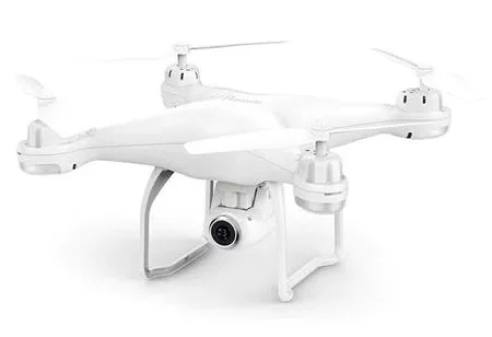
This drone boasts a 2K resolution camera, a decent 15-minute flight time, and a range of up to 300 meters. It also has GPS positioning and a variety of intelligent flight modes.
The Potensic T25 strikes a great balance between affordability and features. The T25 also includes beginner-friendly features like headless mode, altitude hold, and one-key return to home, making it easy to fly for beginners.
Key Features:
- 1080p HD camera with decent image quality
- Stable flight thanks to Altitude Hold and Headless Mode.
- Up to 25 minutes of flight time on a single battery (impressive for the price range).
- Easy-to-use app with intuitive controls.
Pros:
- Relatively affordable price
- Has return to home feature
- Supports headless mode and altitude hold
- Decent flight time up to 15 minutes
Cons:
- Heavier at 2 kg
- Camera may not be ideal for capturing intricate details
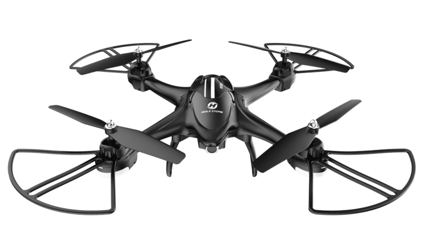
2. Holy Stone HS440: Perfect for Beginners
The Holy Stone HS440 is a fantastic option for absolute beginners. Its compact size and propeller guards make it less intimidating to fly indoors. While the camera is basic, it offers a fun way to capture snapshots from a new perspective. The HS440 boasts a flight time of around 10 minutes and includes features like headless mode and one-key takeoff and landing.
Key-Features:
- Equipped with a 1080P HD camera that can be adjusted within 90°
- Extended flight time of up to 20 minutes
- Has Wi-Fi connectivity
- Comes with Gyroscopic Stabilization and Auto-Landing
- Has Gesture control and Voice control
Pros:
- Ultra-portable
- Beginner-friendly
- Good flight time
Cons:
- Limited range up to 100 meters
- No GPS
- No return to home feature
3. Deerc D50: The Budget Champion
If absolute affordability is your top priority, the Deerc D50 takes the crown. This incredibly budget-friendly option boasts a surprisingly decent camera with 1080p resolution and a respectable flight time of around 24 minutes. The D50 is a great choice for those who want to experiment with drone flying without a significant investment.
Key Features:
- Built-in 2K Ultra HD Camera with 120-degree field of view and adjustable angle
- Offers 360° flips, rolls, and circle
- Comes with 2 modular batteries that reach up to 24 mins
Pros:
- Offers a good balance between camera quality and flight time with a 2K camera
- Flight time of up to 24 minutes
- One-key start and landing
- Offers a user-friendly app and intuitive controls.
Cons:
- Limited range up to 100 meters
- No GPS
- No return to home feature
4. Holy Stone HS200D: The Maneuver Maestro
This drone is another great option for beginners, with a 720p camera, a flight time of up to 18 minutes, and a range of up to 100 meters. It also has headless mode, which makes it easier to control, and altitude hold, which keeps the drone at a consistent height.
Key Features:
- Features a First-Person View (FPV) mode for immersive flying.
- Has Features like Gesture Selfie, 360° Flip, etc.
- Comes with a carrying case for easy transportation.
Pros:
- Affordable price around $80
- Decent flight time up to 18 minutes
- Has a headless mode and altitude hold
Cons:
- No GPS
- No return to home feature
5. Ryze Tello: A Perfect Starter Drone
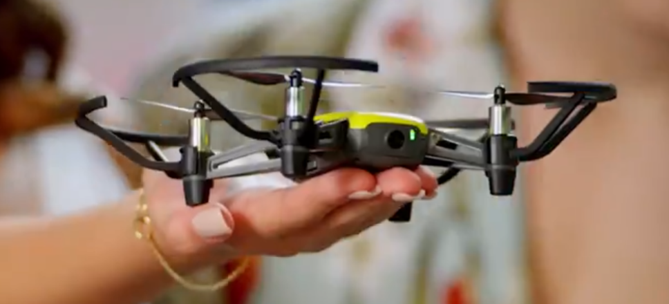
If you’re new to drones or just want something fun and easy to fly, the Ryze Tello is a great choice. It’s compact, lightweight, and super intuitive to control.
This compact and lightweight drone is powered by DJI technology. You can even learn coding with it, which makes it a hit among kids and hobbyists.
Key Features:
- 100 meters range
- 720p HD with electronic image stabilization for smooth footage.
- Up to 13 minutes of flight time on a single charge.
- Supports Scratch programming for coding enthusiasts.
Pros:
- Beginner-friendly controls make it easy to get started.
- Impressive flight stability for a drone in this price range.
- Coding capabilities add an educational twist.
- Lightweight and portable, great for travel or casual use.
Cons:
- Limited camera resolution compared to higher-end models.
- No GPS, so it’s less stable in windy conditions.
- Short range may feel restrictive for some users.
6. Snaptain S5C: Fun and Stunt-Capable
The Snaptain S5C is all about fun. Whether you’re a beginner or just want to entertain friends, this drone brings excitement to the skies with its easy-to-use controls and stunt capabilities. If you’re looking for a budget-friendly option to impress your crowd, the S5C is a fantastic pick.
Key Features:
- 80 meters range
- 720p HD with FPV (First Person View) streaming to your smartphone.
- Up to 10 minutes of flight time per charge.
- Perform 360° flips and tricks with the press of a button.
- Voice and Gesture Control
Pros:
- Stunt features make it highly entertaining for kids and beginners.
- Voice and gesture controls add a unique twist to flying.
- Durable design can handle minor crashes, perfect for learners.
- Affordable price point makes it accessible to most.
Cons:
- Shorter flight time compared to competitors.
- Limited range may not suit those looking for long-distance flying.
- Camera quality is basic and best for casual use.
This list is a starting point to help you narrow down your choices. Research each drone further to see which features and specifications best suit your needs and flying style.
Comparison of Best Drones Under $200
| Feature | Potensic T25 | Holy Stone HS440 | Deerc D50 | Holy Stone HS200D | Ryze Tello | Snaptain S5C |
| Price | $179 | $100 | $125 | Around $80 | $100 | $100 |
| Weight | 2 Kg | 166 g | 178.6 g | 1 Kg | 80 g | 703 g |
| Camera | 1080p | 1080p | 1080p | 720p | 720p | 720p |
| Flight Time | Up to 15 minutes | Up to 20 minutes | Up to 24 minutes | Up to 18 minutes | 13 minutes | Up to 10 minutes |
| Range | Up to 300 meters | Up to 100 meters | Up to 100 meters | Up to 100 meters | Up to 100 meters | Up to 80 meters |
| GPS | Yes | No | No | No | No | No |
| Headless Mode | Yes | Yes | Yes | Yes | No | Yes |
| Altitude Hold | Yes | Yes | Yes | Yes | No | Yes |
| Return to Home | Yes | No | No | No | No | Yes |
| Connectivity | Wi-Fi, USB | Wi-Fi | Wi-Fi | Wi-Fi | N/A | Wi-Fi |
| Special Features | Follow Me Mode, Tap Flight | Gyroscopic Stabilization, Auto-Landing, Emergency Stop, Tap Flight, Circle Flight | One Key Start/Landing, Emergency Stop, Gesture Selfie, Waypoints Flight | Waypoints Flight, Gesture Selfie, 360° Flip, Live Streaming, One-key Take Off/Landing | Throw & Go, Failsafe Protection, Bounce Mode, EZ Shots, 8D Flips | 360° Flips & Rolls, Gesture Control, Voice Control, Gravity Control, Tap to Fly |
Summary
We’ve rounded up six fantastic drones under $200, each with unique strengths to cater to different needs.
If you’re just starting out, look for a model like Holy Stone HS440. It comes with user-friendly controls and stability features to build your confidence.
The Snaptain S5C is an excellent choice for those seeking fun and entertainment. The drone has stunt capabilities and unique controls, such as voice and gesture recognition.
And if photography or exploring vast landscapes excites you, Potensic T25 will be a good choice.
Remember, while these drones are budget-friendly, they pack a punch in performance and versatility. You can make the most of your drone-flying experience with a little practice and creativity.
So, pick the one that suits your needs and enjoy the thrill of the skies.
Happy flying!
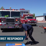
Drone as First Responder: Revolutionizing Emergency Response
Imagine this: a person collapses from a heart attack on a busy city street. Paramedics are minutes away, but if help could arrive just a bit faster, the chances of survival could increase dramatically.
During an emergency, every second counts.
Studies show that reducing response times by even one minute in cases like cardiac arrest can increase survival rates by over 10%.
This urgency has led to innovative solutions to bridge the critical time gap. One such breakthrough is the use of drones as first responders (DFR).
UAVs are capable of delivering life-saving medical supplies or guiding emergency services to the scene.
Could drones become the future of emergency response, saving thousands of lives each year?
This new technology is transforming the landscape of public safety, offering hope where time is most precious.
Let’s understand the role of DFR first.
The Role of Drones as First Responders

DFR programs deploy drones to emergency scenes, often arriving before human responders.
Equipped with advanced tools like high-definition cameras, thermal imaging, and communication devices, these drones deliver real-time data, assess hazardous environments, and transport critical medical supplies such as Automated External Defibrillators (AEDs).
By being the first on the scene, drones are transforming how quickly and safely emergencies are handled.
Drones are no longer a futuristic concept in public safety; they have become a vital part of emergency management worldwide.
Communities in urban, rural, and disaster-prone areas are integrating UAV technology into their response strategies. This shift demonstrates the growing recognition of drone programs as essential for saving lives and protecting property.
Why Drones Are Essential in Emergency Response

The increasing frequency and complexity of emergencies, such as natural disasters, urban crises, and incidents in remote areas, highlight the limitations of traditional response methods.
Here are key areas where drones play a major role:
- Rapid Deployment: Drones can be deployed quickly to assess disaster areas, providing immediate information to responders.
- Aerial Surveillance: They offer a bird’s-eye view of affected areas, helping identify hazards, locate victims, and plan rescue operations.
- Access to Hard-to-Reach Areas: Drones can navigate through inaccessible terrains, such as collapsed buildings, forests, or flooded zones.
- Thermal Imaging: Drones with infrared cameras can detect heat signatures, assisting in locating people trapped in rubble or lost in wilderness areas.
- Minimizing Risk to Rescuers: By surveying dangerous zones, drones reduce the need for human responders to enter unsafe areas initially.
- Communication Support: Drones can act as temporary communication relays in areas where infrastructure is damaged.
- Environmental Monitoring: They help in assessing ongoing hazards like wildfires, floods, or chemical spills, enabling better containment strategies.
- Search and Rescue Operations: Advanced drones equipped with AI can autonomously search large areas, increasing efficiency in locating survivors.
- 24/7 Operation Capability: With night-vision cameras and extended battery life, drones can operate continuously, regardless of time or weather conditions.
Key Benefits of Drone as First Responder in Emergencies

1. Drones Reduce Response Times
One of the most significant advantages of using drones as first responders is their ability to overcome obstacles that delay traditional vehicles, such as traffic congestion or rough terrains.
In urban areas, where traffic jams can hinder emergency vehicles, drones can fly directly to the scene within minutes. This rapid deployment can make a life-saving difference, especially in situations like cardiac arrests or severe trauma, where every second counts.
In rural areas, drones act as lifelines by covering vast distances quickly, ensuring that medical supplies like defibrillators or first-aid kits reach patients promptly.
Unlike traditional responders who may face delays due to poor road infrastructure, emergency drones equipped with advanced navigation systems bypass these challenges, providing critical support before human responders arrive.
For example, when a fire breaks out in an urban neighborhood, a drone with thermal imaging can quickly identify the fire’s source, map the affected area, and relay data to command centers and incoming firefighters.
Similarly, during natural disasters like floods, drones can survey affected areas almost instantly, identifying survivors and accessible routes to prioritize rescue efforts.
2. Keeping Responders Out of Harm’s Way
In emergencies, responder safety is a primary concern. Drones can assess hazardous environments, reducing the risks for human teams.
For instance, during chemical spills, drones equipped with sensors detect toxic substances and provide crucial information, allowing responders to take necessary precautions.
Thermal imaging drones are increasingly used to detect hotspots in burning buildings, offering insights that help firefighters plan their approach.
In disaster zones with unstable structures, drones assess damage, locate survivors, and deliver supplies like food and medical kits, reducing the need for responders to enter unsafe areas.
Similarly, in active shooter situations, drones provide real-time intelligence to law enforcement, helping officers strategize while minimizing risk.
3. Situational Awareness Through Real-Time Data
Equipped with high-definition cameras, thermal imaging, and sensors, drones capture detailed, real-time data that enhances situational awareness for emergency teams.
For example, during search-and-rescue operations, thermal imaging helps locate heat signatures in low-visibility conditions, ensuring resources are directed effectively.
In flood-affected areas, drones monitor water levels, locate stranded individuals, and assess infrastructure stability, enabling a coordinated response.
In law enforcement, drones provide aerial views of crime scenes, aiding tactical planning and evidence collection.
The integration of AI-powered analytics enhances these capabilities further, enabling drones to identify patterns and predict risks, such as wildfire spreads or flood zones, ensuring proactive and informed interventions.
Future Advancements in Drone Technology

The potential for innovation in first-responder drones is immense, with several exciting advancements on the horizon:
- Extended Battery Life: Breakthroughs in energy storage technology will allow drones to operate for longer durations, covering larger areas without needing frequent recharging.
- Increased Payload Capacity: Enhanced materials and design innovations will enable drones to carry heavier and more diverse payloads, from larger medical kits to advanced sensing equipment.
- Modular Designs: The next generation of modular drones will feature even more seamless adaptability, allowing for rapid transitions between missions.
- Enhanced AI Capabilities: Future AI systems will not only analyze data but also predict outcomes, such as identifying areas likely to flood or assessing structural collapse risks before they happen.
- Improved Energy Efficiency: With the integration of renewable energy sources like solar panels, drones will become more sustainable and capable of longer missions.
These advancements promise to redefine the role of drones in public safety, pushing the boundaries of what emergency response teams can achieve.
Conclusion
Drones as first responders are transforming emergency response and public safety by providing life-saving solutions with unmatched speed and precision. They fill critical gaps in traditional systems, enhancing situational awareness, improving decision-making, and delivering essential supplies to even the most challenging locations.
Their versatility makes them invaluable across diverse emergencies, from natural disasters and urban crises to rural healthcare needs.
As technology continues to evolve, drones are poised to play an even more significant role in public safety.
Innovations such as longer battery life, AI-driven analytics, and autonomous navigation systems will lead to faster response times, greater payload capacities, and improved efficiency. These advancements promise a safer, more prepared world where drones are an indispensable tool in saving lives and mitigating disasters.
Frequently Asked Questions
1. What exactly is a “Drone as First Responder” (DFR) program?
A DFR program involves strategically stationed drones that can be quickly deployed to emergency scenes before traditional first responders arrive. These drones are operated by certified pilots from a remote command center and can provide real-time video and situational awareness to emergency personnel.
2. How do DFR drones differ from standard public safety drones?
DFR drones are specifically designed for rapid deployment and extended flight times. They’re typically equipped with sophisticated cameras with both daylight and thermal imaging capabilities, automated takeoff and landing systems, and weather-resistant features.
3. What Does It Mean for a Drone to Be a First Responder?
A drone as a first responder ensures immediate presence at an emergency scene. It often arrives before ambulances, fire trucks, or police. These drones are equipped with cameras, sensors, and communication devices. They provide real-time data to help emergency teams make quick decisions.
Drones can survey hazardous areas and locate victims. They also deliver essential supplies and relay critical information to command centers. This makes them the eyes and ears of human responders.
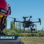
USAIG UAS Insurance: How It Protects Your Drone Operations
Have you ever thought about what could go wrong during a drone operation?
Imagine your drone crashing into a car during a real estate shoot or malfunctioning mid-air while surveying a construction site. These scenarios can result in expensive repairs, liability claims, or even lawsuits.
With the rapid rise of drone technology, having comprehensive insurance coverage is not just a necessity, it’s a responsibility.
USAIG (United States Aircraft Insurance Group), the nearly 90-year-old aviation insurance group, has been making great strides in terms of the policies they are offering drone pilots.
In this article, we’ll explore how USAIG UAS insurance protects your investment, reduces risks, and helps your operations run seamlessly.
Why Drone Operators Need Insurance
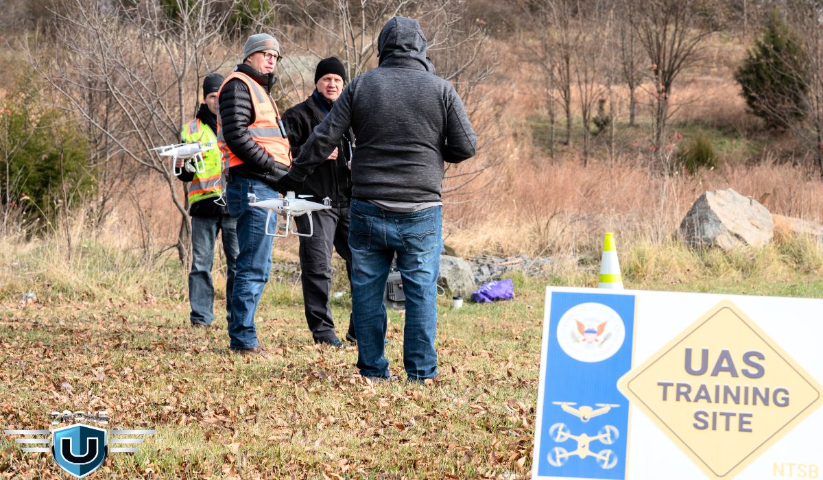
Operating a drone is about more than just flying—it’s about managing responsibility and mitigating risks. Here’s why insurance is essential for drone operators:
1. Accidents Are Unpredictable
Even the most experienced pilots can’t always anticipate sudden wind gusts, technical malfunctions, or signal interference. According to a 2021 FAA report, over 1,700 drone-related incidents were recorded in U.S. airspace within a single year.
2. Third-Party Liability
Drones often operate in areas with people and property, increasing the potential for accidents. For instance, during an outdoor event, a drone collided with a stage setup, causing hefty fines for damages and disrupting the event.
3. High Equipment Costs
Professional drones and their payloads come with hefty price tags, often exceeding $15,000. Repairing or replacing damaged equipment can place a significant financial strain on operators.
4. Regulatory Compliance
Many industries require drone operators to carry liability insurance to comply with FAA regulations and meet client expectations, especially for commercial operations.
What Is USAIG UAS Insurance?

USAIG (United States Aircraft Insurance Group) has been a pioneer in aviation insurance since 1928. The USAIG extends its expertise to the drone sector, offering policies that address unique risks.
With USAIG, you gain access to aviation-exclusive insurance backed by nine decades of aviation expertise, a strong financial foundation, and a global claims network.
What sets USAIG apart is that many of their underwriters are also UAS operators. This firsthand experience provides valuable insights into the unique challenges and risks associated with UAS.
Why Choose USAIG UAS Insurance?

USAIG offers comprehensive coverage options specifically designed for UAS operators, manufacturers, and related equipment.
Here’s a breakdown:
1. Liability Coverage for Third-Party Claims
If your drone causes property damage or bodily injury, USAIG covers the associated costs.
Third-party liability coverages include:
- Premises Liability
- Personal Injury
- Non-Owned Unmanned Aircraft Liability
- Product Liability for Owned Unmanned Aircraft
- War Liability
- Terrorism Risk Insurance Act (TRIA)
2. Physical Damage Coverage
This protects your drone, payload, and ground equipment from damage due to crashes, weather, or other unforeseen incidents.
These physical damage coverages are available:
- Unmanned Aircraft Systems
- Payload or Cameras
- Sensors
- Ground Equipment
- Spare Parts
3. Product Liability for Manufacturers
Component and system design, testing, and evaluation to include:
- System Development
- Component Testing
- Sensor Testing
- Coverage for Large UAS for Special Purpose Missions
4. Performance Vector Program
Performance Vector Unmanned helps promote safe drone operations by providing UAS policyholders with the tools they need to operate safely and comply with regulations. The program aims to build a competent and responsible base of commercial UAS operators.
Performance Vector Unmanned offers safety and loss control services with every USAIG UAS policy. To receive a SafetyPoints allocation, based on the scale and complexity of your coverage, simply request enrollment. Click here to check for the latest offerings.
How to Get a Quote from USAIG
Securing a UAS insurance policy with USAIG is simple:
1. Contact Your Insurance Broker: Discuss your specific risks and needs.
2. Submit an Application: Your broker will provide the necessary forms, which include:
- UAS Insurance Application
- Non-Owned UAS Insurance Application
- Canadian UAS Insurance Applications (if applicable)
3. Receive an Underwriting Response: USAIG will evaluate your application and provide a quote.
If you don’t have a broker, call USAIG at 212-952-0100, and they will recommend a qualified broker in your area.
Electronic Applications and Forms
USAIG provides electronic and print-only application forms for convenience. Some of the key forms include:
Application
- Unmanned Aircraft System (UAS) Insurance Application
- Non-Owned Unmanned Aircraft System (UAS) Insurance Application
- Canadian Unmanned Aircraft System Insurance Application
- Canadian Non-Owned Unmanned Aircraft System Insurance Application
Form
- Unmanned Aircraft System (UAS) – Remote Pilot Record
- Canadian Unmanned Aircraft System Pilot – Operator Record Form
Conclusion
Drone insurance has been a frustrating part of flying commercially for many years. While there are solid options such as Skywatch, it’s nice to have another option to consider. USAIG’s insurance offers comprehensive protection from a solid organization that we think is worth considering.

The 14 Best Mini Drones for 2025 With Pros & Cons
Ever wondered if you could own a drone without breaking the bank? Mini drones have become a game-changer in the drone world, offering incredible versatility and ease of use in a compact, affordable package.
But what makes these tiny flying machines so appealing, and which ones truly stand out?
Did you know that the mini drones market is expected to grow from USD 5.8 billion in 2023 to USD 10.4 billion by 2030, achieving a CAGR of 8.6%?
Whether you’re a beginner looking to master the basics or someone who loves capturing unique aerial shots without the heavy investment, mini drones are the perfect entry point.
In this article, we’ll explore the top mini drones on the market, helping you find the one that offers the best value for your money.
First, let’s clarify what type of drone is considered a ‘mini-drone’.
What is a Mini Drone?
A mini drone is a type of unmanned aircraft system (UAS) that weighs less than 55 grams. These little flying machines are great for taking photos, recording videos, and many other purposes.
Small drones, also commonly referred to as mini drones or micro drones often feature lightweight materials, making them agile and maneuverable in different environments.
Some of these mini-drones have become indispensable tools for aerial photography and videography. While many others are useful for surveying, mapping, or even delivering packages.
What makes a mini drone so appealing? Let’s find out.
Why Should You Buy a Mini Drone?
Mini drones are quite fascinating but due to their small size, many people wonder why choose a small drone. Small drones can be beneficial for several reasons. The following are some justifications for buying a mini drone:
1. Portability
Mini drones are smaller in size as compared to their bigger counterparts. This quality makes it easy to carry them. Their small size enhances mobility and convenience.
2. Indoor usage
Flying indoors is a great use of mini drones. Their compact body makes it easier to control in tight areas. You can easily fly mini drones indoors without running the danger of damaging property or hurting people.
3. Affordability
Mini drones are typically more affordable than their bigger counterparts. This makes them an attractive option for individuals who want to experience drone flying without a significant financial investment.
Before we get into the top mini drones, let us look into the criteria you must consider before buying these amazing machines.
Things to Consider Before Buying a Mini Drone
Whether you’re purchasing a mini drone for recreation or you want to incorporate it into your business, here are a few factors to consider before buying one:
- Price of The Drone
- Material Used
- Range of the Device
- Flying Time
- Camera & Gimble
1. Price of Mini Drones
Before buying a mini drone, make sure to research the cost and availability of replacement parts and accessories. Also, be careful about purchasing third-party parts and accessories. Equipment compatibility is a major issue to consider and they must last as long as the original equipment.
Also, check out the warranty information on any drones you’re considering.
2. Material Used
Cheaper drones are often made from plastic. While plastic can be inexpensive and light, it‘s not always durable. Also, avoid using aluminum drones, they are lightweight and do not hold up well to accidents.
If you’re trying to save money, at least consider ABS plastic, which is stronger than regular plastic. Or consider fiberglass and Carbon Fiber drones, they are much more resilient but much more expensive.
3. Range of a Mini Drone
As a general rule the farther your drone can fly from your transmitter the better. Cheap drones may have a limited range of only 30 meters, whereas more expensive ones can cover longer distances without losing contact with the controller.
If you’re interested in making drone footage and photography then the range becomes an important factor because extended range will allow drones to reach more places. And you will be able to take shots from a variety of angles.
4. Flying Time
A drone’s battery limits how long it takes to fly, 25 to 30 minutes of flying time is pretty typical. But some cheaper models last for only five minutes.
Regardless of how much flying time your drone has, buying some additional batteries and charging them before you leave home is always a good idea. So if your drone runs out of power, you can swap the battery and instantly double the time you’re able to fly!
5. Camera
If you are considering a drone with a camera it’s better to check out the camera specifications, paying attention to shutter speed, frame rate, aperture, and image stabilization.
All of these factors may affect the quality of your photographs.
6. 3-Axis Gimbal
A gimbal helps keep your camera stable while you fly. Three axes (pitch, roll, and yaws) describe a drone’s different motions.
A three-axis gimballed camera will let your drone stay steady while you shoot videos. This is especially important for aerial shots because the camera needs to remain leveled so everything appears straight.
Read: New Drone Laws by State in the USA
List of 14 Best Mini Drones
There are several types of mini drones, each with its unique set of features and applications. Some are designed for specific purposes, such as surveillance, while others are meant for recreational purposes.
Here are the best mini drones in 2025
- DJI Mini 4 Pro
- DJI Neo
- DJI Mini 3 Pro
- DJI Mini 4K
- Hoverair X1
- DJI Air 3
- iFlight Bumblebee HD V3 BNF
- Autel EVO Nano+
- Parrot Anafi Ai
- DJI Air 2S
- DJI Mavic 2 Enterprise Advanced
- Autel Evo II Pro
- DJI Avata 2
- Ryze Tello
1. DJI Mini 4 Pro
 Source: DJI
The DJI Mini 4 Pro is a high-end camera drone that weighs less than 249 grams, making it perfect for travel and on-the-go use. It features a 1/1.3? CMOS sensor that can record 4K/60fps HDR videos with stunning detail, even in challenging lighting conditions. The drone also has omnidirectional obstacle sensing, which helps it avoid obstacles and fly safely. Additionally, the Mini 4 Pro has a max transmission distance of up to 20 km, so you can capture amazing footage from far away.
Features and Specifications of DJI Mini 4 Pro
- Under 249 gm
- 4K/60fps HDR
- 1/1.3-inch CMOS Wide-Angle Camera
- 10-bit D-Log M, HLG
- Slow Motion: 4K/100fps
- Active 360° shots
- Up to 20 km Max Video Transmission Range
Pros and Cons of DJI Mini 4 Pro
Pros
- Enhanced performance of the low-light camera
- Smooth 1080p 60 fps video transmission
- Superb tracking and obstacle avoidance
- Extended battery life up to 45 minutes
Cons
- Expensive
- Doesn’t perform great in low light camera
2. DJI Neo
Source: DJI
The DJI Neo is all about making your drone experience easy and fun. With features like palm takeoff and landing, AI-powered subject tracking, and eight QuickShots modes, it’s perfect for effortless vlogging. At just 135g, this ultra-lightweight drone doesn’t require FAA registration or Remote ID, so you can take it out and fly without any extra hassle.
You can use voice commands, a mobile app, or a remote controller, whatever suits you best to control the drone. Plus, its full-coverage propeller guards add an extra layer of safety while keeping it portable and stress-free to use. The package even comes with a battery and propeller guards, so you’re ready to go right out of the box.
Features and Specifications of DJI Neo
- Approx. 135 gm takeoff weight
- Dimensions are 130×157×48.5 mm
- ½-inch image sensor 12MP Camera
- 22GB internal storage & 40 minutes of 4K video capacity
- Maximum flight distance of 7 KM
- Single-axis mechanical gimbal
- Up to 18 minutes of flight time on a single charge
Pros and Cons of DJI Neo
Pros
- Compact and lightweight design.
- Capture smooth, stabilized aerial footage.
- Easily takes off from and lands in the palm of your hand.
- User-friendly automated flight modes.
Cons
- Absence of Remote ID may be an issue for licensed pilots
- Cumbersome manual flight controls in the mobile app
- Restricted operating range without a physical remote (sold separately)
3. DJI Mini 3 Pro
 Source: DJI
The mini-sized DJI Mini 3 Pro is as powerful and portable as it is regulation-friendly. It comes with a 1/1.3-inch sensor and top-tier capabilities and weighs under 250 grams. Its improved design and upgraded features such as obstacle sensing make it safer and easier to fly this mini drone.
Features and Specifications of DJI Mini 3 Pro
- Covers a distance of up to 12 km
- 1/1.3-inch CMOS sensor
- 4K HDR video and 48MP RAW photos
- Extended flight time of up to 34 minutes
- Tri-Directional Obstacle Sensing
Pros and Cons of DJI Mini 3 Pro
Pros
- 4K60 with digital zoom
- Popular sub 250g category
- Excellent image quality
- Three-way obstacle sensors
- Upward-tilting camera
- Two remote control options
Cons
- GPS lock-on takes some time
- Expensive
- Omits AirSense ADS-B system
4. DJI Mini 4K
Source: DJI
The DJI Mini 4K brings aerial photography to everyone, making it simple and fun for both beginners and enthusiasts.
Weighing less than 249g, this palm-sized drone is super portable and often doesn’t need registration in many places.
It is equipped with a 4K camera, a 31-minute flight time, and excellent wind resistance.
You can capture breathtaking landscapes or spontaneous moments with the Mini 4K.
Features and Specifications of DJI Mini 4K
- 1/2.3-inch CMOS camera with 4K video
- 10km HD video transmission via DJI O2
- 31-minute max flight time
- 38kph (Level 5) wind resistance
- 4000m max takeoff altitude
- Weighs under 249g
Pros and Cons of DJI Mini 4K
Pros
- Easy for beginners with one-tap takeoff and landing
- Compact and portable, no registration required
- Stunning 4K video quality
- Intelligent modes for impressive QuickShots and Panoramas
- Long-range, up to 10km video transmission
- Excellent stability in windy conditions
Cons
- No obstacle avoidance, requiring manual control.
- No built-in storage; needs a microSD card.
- Gimbal movement limited, restricting angles.
- Incompatible with ND filters from older models, adding extra costs.
5. Hoverair X1
The HoverAir X1 is incredibly portable. It’s super lightweight and folds up small, making it a great choice if you want a drone you can easily take it anywhere. It’s also very simple to fly.
There’s no need for a phone app or complicated controls, which is perfect for beginners or anyone who wants a hassle-free flying experience.
This lets the drone automatically follow you, which is great for capturing activities hands-free. The video quality is decent too, shooting in 2.7K resolution and taking 12MP photos, which is good enough for social media or casual use.
However, You won’t find things like obstacle avoidance or complex flight modes that some other drones offer.
Features and Specifications of HoverAir X1
- Folds to pocket-size, lightweight.
- Shoots 2.7K video, 12MP photos.
- Stabilized footage with gimbal and electronic stabilization.
- Multiple intelligent flight modes (Follow Me, Orbit, etc.).
- Noise cancellation for clearer audio recording.
Pros and Cons of HoverAir X1
Pros
- Incredibly lightweight and folds up very small, making it easy to carry anywhere.
- No phone app or complex controls are needed. Great for beginners or those wanting a hassle-free option.
- Automatically follows you for hands-free capturing of activities.
- Shoots in 2.7K resolution, good enough for social media or casual use.
Cons
- Lacks advanced features like obstacle avoidance or complex flight modes found in some drones.
- Battery life is around 15 minutes, which might be limiting for some users.
- May struggle to fly in windy conditions due to its lightweight design.
6. DJI Air 3
DJI Air 3 is the dream of every aerial photographer, it is one of the best mini drones with a camera. It comes with two industry-leading Hasselblad cameras. The DJI Air 3 offers one of the best camera performances along with expert camera options, sharper details, and vibrant colors. The DJI Air 3 features everything you need in one of the top camera drones on the market, especially if you love shooting panos and HDR photos.
Features and Specifications of DJI Air 3
- (2x) 1-1/3” CMOS Sensor
- Wide-Angle Camera |FOV: 82°| Format Equivalent: 24 mm | Aperture: f/1.7
- Medium Tele Camera | FOV: 35° | Format Equivalent: 70 mm | Aperture: f/2.8
- 46 minutes (at a consistent 25 kph) max flight time
- 32 km max distance
- 29–38 kph wind speed resistance
- Omnidirectional Obstacle Sensing
- Wide-Angle Camera & Medium Tele Camera
- Normal: 8-bit 4:2:0 (H.264/H.265)
- HLG/D-Log M: 10-bit 4:2:0 (H.265)
Pros and Cons of DJI Air 3
Pros
- Great battery life
- 48MP Raw and JPG still imaging
- Obstacle avoidance sensors
- 4K video at 60FPS with high color gamut
- Can use dual cameras for dolly zoom effect
Cons
- Not for chasing objects
- Larger than most mini drones
7. iFlight Bumblebee HD V3
 Source: iFlight
The iFlight BumbleBee HD V3 comes with the amazing CaddX Polar Digital HD System which allows you to fly through the sky like no other mini drone. It has a CineWhoop that doesn’t have a high-pitched noise that annoys people. Mini drone iFlight BumbleBee HD V3 has lightweight Polycarbonate ducts for minimal disturbance to channel thrust and performance.
Features and Specifications of iFlight BumbleBee HD V3
- Bumper prop guards to protect the sensitive environment
- T700 Quality Carbon
- Upgraded EVA protectors
- Low Resonance frame construction
- 355.6g weight (without battery)
Pros and Cons of iFlight BumbleBee HD V3
Pros
- Great for beginners
- Not easy to break
- Upgraded EVA protectors
- No Props or frame in view
Cons
- Expensive
- Heavy
- Creates too much noise
8. Autel EVO Nano+
Source: Autel Robotics
The Autel EVO Nano+ is your go-to for amazing aerial photography in a super compact, lightweight package. Weighing just 249 grams, it’s easy to carry around but packed with powerful features. You get a 1/1.28-inch CMOS sensor for stunning 50MP photos and 4K/30fps video, so your shots always look incredible.
It’s also got advanced autofocus, HDR capabilities, and three-way obstacle avoidance, so your flights are smooth, safe, and hassle-free. Whether you’re a beginner or a pro, the EVO Nano+ makes capturing those cinematic moments super simple and fun.
Features and Specifications of Autel Evo Nano+
- 1/1.28-inch RYYB CMOS sensor (Nano+) with 50MP resolution
- 48MP 4K/30fps video recording (Nano) with three-axis gimbal
- 6.2-mile SkyLink video transmission with 2.7K/30fps quality
- 28-minute max flight time
- Advanced obstacle avoidance with three-way binocular vision sensors
- Dynamic Track 2.1 for subject tracking
- SuperDownload at 160Mbps (20MB/s)
Pros and Cons of Autel Evo Nano+
Pros
- Lightweight and portable, weighing only 249 grams
- High-quality 50MP photos and 4K stabilized video
- HDR mode for improved contrast and dynamic range
- Multiple color options for a personalized style
- Intelligent features like SkyPortrait, Dynamic Track, and MovieMaster for easy, cinematic shots
- Long transmission range and strong anti-interference capabilities
- Advanced safety features with obstacle avoidance
- Easy media downloads and sound recording for enhanced video creation
Cons
- Joysticks are hard to screw in and may cross-thread; redesign suggested
- Cable port placement risks damaging cables when closing the holder
- Video output may appear overprocessed
- Log profile is limited to 8-bit
- Price point is on the higher side
9. Parrot Anafi Ai
 Source: Parrot
Parrot Anafi Ai incorporates a 4G radio module, in addition to the Wi-fi radio, allowing it to transmit a video stream in 1080p with a 300 ms latency anywhere in the world. Its sensor supports a high megapixel count for finely detailed aerial images. Mini drone Parrot Anafi Ai uses a Quad Bayer color filter array, where groups of 4 adjacent pixels come in one single color. In real-time HDR capture mode, the signal from the four adjacent pixels is added together, resulting in an image with a greater dynamic range.
Features and Specifications of Parrot Anafi Ai
- 1/2’’ 48 MP CMOS Sensor
- Seamless 4G/WiFi switching
- 4K HDR 30 fps video, 6x zoom
- 32 minutes maximum flight time
- 14 m/s – 31.3 mph maximum wind resistance
- MicroSD and SIM card slots
- Autonomous Photogrammetry for large-scale mapping
Pros and Cons of Parrot Anafi Ai
Pros
- High wind resistance
- Unique lens and camera features
- Adequate battery life
- Small and lightweight
Cons
- Difficult to fly
- Limited video frame rates
- Autonomous features require an extra purchase
10. DJI Air 2S
 Source: DJI
DJI Air 2S is the ultimate mini drone for creatives on the go. Take this all-encompassing aerial powerhouse along anywhere to explore and record your world in breathtaking detail. With a 1-inch CMOS sensor, powerful autonomous features, and a compact body measuring just under 600g.
DJI Air 2S allows you to shoot RAW images with an impressive dynamic range of up to 12.6 stops to capture more visual data in every scene, even in challenging lighting conditions. The advanced algorithms for Advanced Pilot Assistance Systems (APAS 4.0) have been further refined, enabling mini drone DJI Air 2S to actively avoid obstacles in increasingly complex situations and at higher speeds.
Features and Specifications of DJI Air 2S
- 1-inch CMOS sensor
- 5.4K/30fps and 4K/60fps Video (20 MP camera)
- Master shots, ADS-B Air sense
- 12km FHD Transmission
- Obstacle Sensing in 4 Directions
Pros and Cons of DJI Air 2S
Pros
- HDR, Log, and Standard video profiles
- Video at up to 5.4K quality
- AirSense transponder
- Robust safety features
- Automated camera shots
- Half-hour flight time
Cons
- Less internal storage
- Doesn’t offer in-camera filters
- HDR HLG workflow for pros only
- The remote doesn’t include an EV control wheel
- Raw images don’t transfer to smartphones and tablets automatically
- App-based editing limited to 1080p output
11. DJI Mavic 2 Enterprise Advanced
 Source: DJI
The DJI Mavic 2 Enterprise Advanced is a mini drone designed for professional aerial photography and videography missions. Its advanced features include a powerful camera system, precise positioning capabilities, and intelligent flight control systems. DJI Mavic 2 Enterprise Advanced allows you to capture accurate details with high-resolution thermal and visual cameras.
Features and Specifications of DJI Mavic 2 Enterprise Advanced
- 1/2” CMOS Sensor
- 640 × 512 px Thermal Camera
- 48MP Camera
- Working Temperature from -10° C to 40° C
- Omnidirectional Obstacle Sensing
- 10 km HD Transmission
- Centimeter-level Positioning with RTK
Pros and Cons of DJI Mavic 2 Enterprise Advanced
Pros
- Lightweight and portable
- Omnidirectional obstacle sensing
- Fully compatible and can integrate an RTK module
Cons
- Single RTK antenna hinders centimeter-level accuracy
- Thermal camera may lack adjustability in some settings compared to higher-end models.
- Expensive
12. Autel Evo II Pro
 Source: Autel
Autel Evo II Pro is also one of the popular mini drones with a camera. Its most notable feature is a modular camera system, offering three models that cover a range of features that meet different users’ needs, from consumers to professionals.
The standout feature of this mini drone is a modular camera system, which comes in three types and offers a variety of features to fulfill the needs of different users, from amateurs to experts.
Features and Specifications of Autel Evo II Pro
- 1-inch CMOS image sensor
- 20MP Camera, 6K/30FPS Video
- 15 km flight distance
- 5-Hour Battery Life
- 40 minutes Maximum Flight Time
- 27mph (12m/s) Maximum Wind Resistance
- 360° Obstacle Avoidance
- -10°C to 40°C Operating Temperature
Pros and Cons of Autel Evo II Pro
Pros
- Adjustable aperture
- 20MP stills in Raw DNG or JPG
- Subject tracking and cinematic flight modes
- Up to 5.4K video and Raw Photos
- Automated camera moves and Hyperlapse
Cons
- The color video profile isn’t configurable
- Doesn’t support autonomous navigation around obstructions
- 8-bit flat video profile
- Log Color only available in Auto
13. DJI Avata 2
 Source: DJI
The DJI Avata 2 is all about taking your FPV flying to the next level. With better imaging, longer flight times, and upgraded safety features, it’s designed to give you an incredible experience. Pair it with the DJI Goggles 3 and DJI RC Motion 3, and you’re in for some seriously immersive flying.
Whether you’re just getting started or you’ve been flying for a while, the Avata 2 makes things easy with intuitive controls and smooth aerial maneuvers. Plus, the 4K visuals are stunning, and the added stability and safety features mean you can focus on having fun.
Curious to know more? Check out this review on the Avata 2!
Features and Specifications of DJI Avata 2
- Weight: Approx. 377 g
- Flight Time: Max 23 minutes
- Camera: 1/1.3-inch CMOS sensor, 12 MP, 4K video at 60fps
- Field of View: 155° Super-Wide
- Stabilization: RockSteady 3.0+, Gyroflow offline stabilization
- Video Transmission: O4 system, 13 km range, 1080p at 100fps
- Internal Storage: 46 GB
- Sensors: Downward and backward visual positioning
- Max Horizontal Speed: 27 m/s in Manual Mode* (*19 m/s in EU regions)
Pros and Cons of DJI Avata 2
Pros
- Immersive FPV flying with low-latency video transmission.
- Supports advanced aerial maneuvers like flips, rolls, and drifts.
- Durable and lightweight design with integrated propeller guard.
- Turtle Mode enables recovery from upside-down positions.
- Enhanced stability with binocular fisheye sensors.
- 23-minute flight time with PD fast-charging support.
- High-quality imaging in low-light conditions.
- User-friendly editing tools like LightCut for quick content creation.
Cons
- Limited Compatibility: Works only with DJI Goggles 3 and RC Motion 3, making older FPV systems obsolete.
- Dependent on Goggles Power: Remote needs powered goggles, risking signal loss if goggles shut off.
- No Backward Compatibility: Incompatible with DJI Goggles 2, Integra, or older FPV gear.
- Setup Learning Curve: Takes time to fully optimize settings for peak performance.
14. Ryze Tello
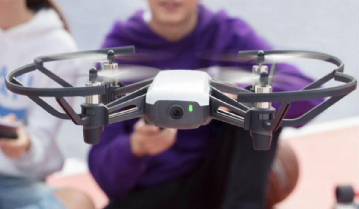
Source: Ryze Robotics
The Tello drone is perfect for kids and adults who want to have fun and learn something new. It’s super easy to fly, packed with cool features, and even lets you dive into coding. Whether you’re exploring from above or showing off some aerial tricks, Tello makes it all simple and exciting.
Built with DJI’s industry-leading flight tech, it’s lightweight, durable, and designed to be user-friendly. From beginners to drone enthusiasts, Tello offers a fun and functional flying experience that everyone can enjoy.
Features and Specifications of Ryze Tello
- Flight Time: Up to 13 minutes
- Flight Distance: 100 meters
- Camera: 720p HD transmission, 5 MP photos, electronic image stabilization
- Processor: Powered by Intel for professional-grade video quality
- Antennas: Dual antennas with smart switching for stable video transmission
- App Compatibility: Tello App with a user-friendly interface
Pros and Cons of Ryze Tello
Pros
- Beginner-Friendly: Intuitive controls with VR compatibility for immersive flying.
- Exciting Features: Perform 8D flips, “Throw & Go,” and bounce mode with ease.
- Quality Media: Capture and share sharp photos and videos effortlessly.
- Stable Flights: DJI tech and vision positioning ensure steady performance.
- Durable Build: Lightweight, robust design with reliable protections.
- Educational Tool: Supports Scratch programming for fun learning.
- Enhanced Safety: Auto takeoff/landing, battery alerts, and failsafe systems.
Cons
- Difficulty maintaining stable hover.
- Poor battery charge-to-flight time ratio.
- Video quality can be pixelated.
- Lacks GPS and return-to-home functionality.
In the next section, we will compare all the important features of all drones.
Mini Drones Comparison Table
Here you can find a detailed comparison drawn among all the categories of mini-drones to evaluate their performance and features.
| Model | Camera | Range | Flight Time | Best For | Weight |
| DJI Mini 4 Pro | 4K 48MP | 18 km | 45 min | Professional photography | < 249 g |
| DJI Neo | ½ -inch image sensor, 12MP | 7 km | 18 min | Beginners, Outdoor Adventures | 135 g |
| DJI Mini 3 Pro | 4K | 12 km | 34 min | Hobby/Recreational | < 250 g |
| DJI Mini 4K | 1/1.28 -inch CMOS camera with 4k video | 10 km | 31 min | Beginners, casual photography | < 249 g |
| Hoverair X1 | 2.7K | 30 m | 35 min | Hobby/Recreational | 125 g |
| DJI Air 3 | 4K, 48 MP | 32 km | 42 min | Professional | 720 g |
| iFlight Bumblebee HD V3 BNF | Caddx Polar Vista Digital HD System | 4 km | 6 min | FPV Racing/Freestyle | 355.6 g without battery |
| Autel Evo Nano+ | 1/1.28-inch CMOS sensor, 50MP photos | 17 km | 28min | Beginners, travel, casual photography | < 249 g |
| Parrot Anafi Ai | 4K, 32MP | 4 km | 32 min | Professional | 320 g |
| DJI Air 2S | 5.4K, 20MP | 12 km | 31 min | Professional | 595 g |
| DJI Mavic 2 Enterprise Advanced | 4K, 20MP | 8 km | 31 min | Commercial/Enterprise | 899 g |
| Autel Evo II Pro | 6K | 9 km | 40 min | Professional/Enterprise | 1192 g |
| DJI Avata 2 | 1/1.13 inch CMOS sensor, 12MP | 13 km | 23 min | Professional. Filming, Professional Sports | 377 g |
| Ryze Tello | 5MP photos, 720p video | 100 m | 13 min | Beginners, kids, educational use | 80 g |
Conclusion
Mini drones are becoming popular due to their ability to provide stunning aerial images and video footage, which otherwise wouldn’t be possible. With all the cool tech advancements, it’s no wonder people are buzzing about owning one of these tiny flying machines.
But before you jump in and buy a mini drone, consider size, weight, how long it can fly, battery life, camera quality, and how far it can go. These all play a big role.
And don’t forget to register with the FAA if your drone weighs more than 0.55 pounds (250 grams).
So, what are your thoughts on mini drones? We’d love to hear your experiences or questions in the comments below!
Frequently Asked Questions
1. Can mini drones be used for professional purposes?
Yes, mini drones are small in size but can be used for professional use. Even drones like the DJI Mavic 2 Enterprise Advanced, are designed for professional aerial photography and videography missions. They come with specialized features, precise positioning, and high-resolution cameras.
2. Why are mini drones considered suitable for beginners?
Generally, mini drones are more affordable, portable, and easy to control, making them an ideal choice for beginners. Some of the mini drones for beginners and new pilots include DJI Mini 3 Pro and DJI Mini 2 SE. However, all mini drones are not designed for learners, so it is recommended to choose your mini drone based on your needs.
3. How long can you fly a mini drone?
Flying time refers to how long a drone can stay in the air on a single battery charge, influencing the duration of your flying sessions. Every mini-drone has a different flying time. The drone manufacturer usually specifies the flying time ranging from a few minutes to around 30 minutes for more advanced models.
4. Do I need FAA registration for my drone?
Registration depends on the drone’s weight. Models like the DJI Neo at 135g don’t require FAA registration or Remote ID.
5. How do I start a drone-based business?
You’ll need an FAA Part 107 license, which you can earn through courses from the Drone U or other training providers.
The Best Drone Mapping Software: A Comprehensive Guide 2025
Drone mapping has become an indispensable tool for industries ranging from construction and agriculture to disaster response and government operations. The best drone mapping software can elevate your projects by producing accurate, detailed deliverables efficiently. Below, we explore some of the best mapping software solutions available, highlighting their strengths and weaknesses to help you make an informed decision. We truly believe that with the evolution of the drone mapping software world, that ESRI’s Sitescan is the best online based mapping software.
TLDR:
- Sitescan : Best for government, SLED operations, Integration into ArcGIS
- Pix4d Mapper : best all around value
- Drone Deploy: Best for Volumes, Inlays
- Reality Capture: Best 3d Models
1. Pix4D Mapper: The All-Around Mapping Powerhouse
Pix4D Mapper remains the gold standard for all-around drone mapping software. It excels at teaching the essential systems necessary for mapping while allowing users to produce deliverables of all kinds, including orthomosaics, digital surface models (DSMs), and 3D point clouds. Notably, it’s still the most accurate point cloud generator on the market, making it the go-to choice for precision mapping.
Pros:
- Highly accurate point cloud generation.
- Comprehensive deliverable options for varied projects.
- Robust features for photogrammetry-based mapping.
- Advanced Mapping Deliverables like Pointcloud Hyperlapses
Cons:
- Weak reporting tools that leave much to be desired.
- Poor-quality topographic map outputs.
Take our Pix4d Mapper Mastery Class today.
2. DroneDeploy: The Popular Cloud-Based Mapping
DroneDeploy has established itself as a top-tier cloud-based mapping platform. It shines in producing orthomosaics and digital surface models and offers a seamless online interface for data processing and collaboration. However, its performance with 3D models doesn’t match up to some competitors.
Pros:
- Exceptional for orthomosaics and digital surface models.
- Easy-to-use, cloud-based platform.
- Enables collaboration and sharing among teams.
- Best for Volumetrics, change aggregate density
- Added Video Animation tool to empower marketing
Cons:
- Expensive, which can deter smaller operators.
- Subpar 3D modeling capabilities compared to other software.
Take our Drone Deploy Class today.
3. Esri SiteScan: Seamless Integration with Legacy Systems
Esri’s SiteScan software offers one of the most seamless workflows for 2D and 3D mapping. Its user-friendly platform excels in orthomosaics, 3D models, and data sharing. What sets SiteScan apart is its unique integration with ArcGIS, enabling instant sharing of mapping outputs with legacy datasets commonly used by government organizations.
Pros:
- Best cloud-based 3D modeling software.
- Outstanding reporting and image inspection tools.
- Easy sharing and collaboration with ArcGIS integration.
Cons:
- Requires an ArcGIS ecosystem for full potential, which can add costs for users not already using Esri products
4. Reality Capture: The 3D Modeling Specialist
When it comes to creating lifelike 3D models, Capturing Reality is second to none. Its specialized features make it ideal for projects demanding photorealistic outputs, whether for virtual reality, construction, or urban planning.
Pros:
- Superior 3D modeling capabilities.
- Excellent texture and detail in outputs.
Cons:
- Requires high-quality data inputs to perform optimally.
- Not as versatile for 2D deliverables or general mapping tasks.
5. Pix4D Matic: Large-Scale Mapping Made Easy
For large-scale projects, Pix4Dmatic offers a significant upgrade over Pix4Dmapper. It handles massive datasets efficiently, delivering better 3D textured meshes and faster processing times, making it an excellent choice for large-scale mapping operations.
Pros:
- Faster processing times than Pix4Dmapper.
- Produces better 3D textured meshes.
- Optimized for large-scale mapping projects.
Cons:
- Limited feature set compared to Pix4Dmapper for smaller projects.
6. Agisoft Metashape: Blending Photogrammetry and LiDAR
Agisoft Metashape is an outstanding software for combining LiDAR and photogrammetric data to produce incredibly accurate 3D models. Its ability to merge these datasets makes it ideal for industries requiring lifelike models with precise measurements.
Pros:
- Exceptional for combining LiDAR and photogrammetric outputs.
- Produces extremely accurate, detailed 3D models.
Cons:
- Russian-based software, limiting its use for critical infrastructure clients and federal contracts.
7. Pix4Dreact: Rapid Response Mapping
When speed is essential, Pix4Dreact stands out as the fastest orthomosaic mapping software available. Designed for emergency response and time-sensitive applications, it quickly produces actionable maps without compromising quality.
Pros:
- Fastest orthomosaic generation on the market.
- Ideal for disaster response and emergency scenarios.
Cons:
- Limited to orthomosaic creation; lacks advanced 3D modeling capabilities.
8. DJI Terra: Excellent Point Cloud Editing with Limitations
DJI Terra offers some of the best point cloud editing tools, including features like water replacement, making it a popular choice for certain applications. However, its ties to Chinese manufacturing have led to restrictions, particularly for federal contracts in the U.S.
Pros:
- Advanced point cloud editing tools.
- User-friendly interface.
Cons:
- Limited use due to Chinese origin, with restrictions under federal contracts.
- Banned for many government-related projects.
Final Thoughts
The choice of mapping software depends on your project’s specific needs, budget, and data-sharing requirements. Pix4Dmapper remains the all-around best choice for versatility and accuracy, while DroneDeploy excels in cloud-based orthomosaics and Esri SiteScan sets the standard for seamless integration with legacy systems. For specialized needs, Capturing Reality and Pix4Dmatic offer cutting-edge solutions for 3D modeling and large-scale projects, respectively.
As the industry evolves, drone operators must weigh the strengths and weaknesses of these platforms to maximize efficiency and deliver high-quality outputs. Whether you’re working on large-scale construction projects, emergency response, or precise 3D modeling, there’s a software solution tailored to your goals.

Updating the DJI Drone Ban: What You Need to Know About Section 1709 of the FY25 NDAA
TLDR: Section 1709 is a wider scope DJI ban than the CCP drone act, and would cease operations of all DJI drones within a year of passing. If and when it passes.
Continue reading
-
 Brinc Admits, We Caused the DJI Drone Ban! EXCLUSIVE
-
 Brinc Admits they're behind DJI Ban | Auterion Creates Drone Swarm Brain
-
 Trump Card on the DJI Ban, May be Best drone news of 2025. Will he tiktok DJI?
-
 This Drone Trick Makes Real Estate Videos Awesome!
-
 Exploring Drone Security: Opportunities and Challenges
More on Hot Topics