
TSA Drone Policy | Traveling with a Drone
Traveling Tips and Little Known Facts for Drone Pilots – How to Get Free Luggage and Ensure a Successful Trip
In this blog post, I reveal TSA drone policy, and share various Tips and Trick which will help you SAVE money while traveling with a drone.
As a drone pilot in the United States, I’m frequently called to film various productions to train drone pilots all over the United States and beyond. While international travel and even long distance domestic has its own unique nuances, I’ll be focusing on the mainland for today. Whether you are taking a short regional flight, or flying cross country there are certain nuances that will help you save money and time.
This article is meant to share information that can help ease headaches and increase the amount of money in your pocket. You’ll learn how to get 200lbs of free baggage and how to avoid arguments with gate agents.
When Traveling with a Drone – Fly Southwest
Big Bins = No Fighting on Checking Bags Full of Drone Batteries
As most of you know, you cannot check your lithium batteries underneath the aircraft. So most drone pilots leave their remotes, props, drone and various other accessories in their cases to check. There are some cases specifically made to be carry on cases for your batteries.
Ever notice when you’re flying from Denver to Austin or San Antonio to Phoenix, you’re sometimes on a small jet. Since you have to carry all of your batteries, this can potentially pose a problem when you’re flying on small regional jets. Often times, little jets like the CRJ-700 or the ATR-42 have small overhead bins, and airlines like American and United try to get passengers to gate check their luggage. This can often times cause a big problem. This is another reason to fly Southwest – they all fly 737’s which have overhead bins that can actually fit cases and roller wheel bags.
Even if you’re flying on a larger aircraft, and if you’re late to the gate or in the tail end of the general boarding area, you may not be able to have enough space in the overhead bins for your carry-on battery case. And if you’re already carrying a camera bag or a personal bag, you’re really in trouble.
The agents may try to force you to put the bag below the aircraft. I’ve had to argue with an American Airlines flight attendant who told me that if I didn’t put the bag under the aircraft, she would have to call the FAA. I responded with “Call the FAA. Here’s my FAA license and I know that by putting lithium batteries below the plane you’ll be breaking federal law.” That’s when a pilot flying stand-by stood up and said, “Put the bag in the flight attendants closet now.”
She put my bag in the closet and it was over. Albeit, not every outcome ends pleasurably. Since then, the only time I’ve flown American was to Hawaii because Southwest wasn’t offering the service yet. Otherwise I’ve gone above and beyond to avoid that airline like the plague. It’s difficult to have good customer service when the CEO and company do not provide systems, resources and a culture of helping each other out.
So that’s why I fly Southwest every time I can!!! Southwest uses mostly 737’s providing for ample overhead bin space for your batteries. Long story short, you can actually rack up significant points for Southwest airlines if you sign up for their credit card. Buy everything on the card, pay it off each month, and you’ll earn a few free flights within 2 months. In addition, it will give you certain perks that will help you stay ahead of the line to ensure overhead bin space.
Traveling Tips for drone pilots:
- Put your batteries in a special carry-on luggage or lipo bags that prevents the leads of the batteries from being exposed
- Ensure that your bag will actually fit in most carry-on luggage
- Go to GPC cases to get a battery case
- Print out the rules and carry your FAA certificate with you
TSA Drone Policy for Checked LUGGAGE – A reason for Drone Pilots to Rejoice
Southwest recently changed their luggage rules and it has made many production companies and drone pilots very happy. Now, drone pilots or commercial production houses and media houses can board with free luggage. These two bags do not have to be under 50lbs either. With media luggage you can actually have up to 2 bags that weigh up to 99lbs, and yes they can be oversized too!
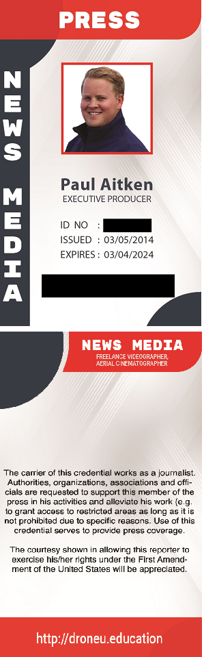
The key to this rule is having a “press pass.” I know you’re probably thinking, “I don’t deserve a press pass and special access”. Let me shut up your inner negative Nancy voice now… YES YOU DO. Do you know who is entitled to a press pass in the US? Under the Constitution of the United States, anyone protected by the First Amendment is legally entitled to a press pass. I learned this after researching press passes via the National Press Photographers Association. You can even skip the hassle of making your own press pass – Just join that community and get a press pass for $48.00. A quality option that is probably also the easiest solution.
Note:
Typically, I travel every two weeks or bi-monthly as a promise to be home more for my wife. As I’ve been traveling consistently, I’ve noticed that even the most experienced gate agents are completely clueless when it comes to baggage fees. I wrote this article a few weeks ago and waited to post it as I wanted to showcase pictures of different ways to acquire press passes. I tested my press pass and it worked flawlessly, except the gate agent had no idea about the policy, and even tried to charge me for the extra size. This, after she told me she was an experienced agent of 22 years and completely didn’t know the policy at all and made a complete idiot of herself. It was rather entertaining! She could certainly use a good class in customer service. It’s ok to not know everything!!! Either way, once her manager came over and I showed her the copy of the rules, they let me go with two free bags, both over 50lbs – goes to show that there is some truth to the Freakonomics episode about how old doctors being worse than new doctors. Statistically, maybe the same rule can go for other careers.
So, how do you get free overweight, oversize baggage on Southwest Airlines?
Quick and Dirty – Define it as media luggage, print out the rule, provide a press pass and walk away!
Keys to success:
- Know the rules and bring a copy to the counter. Print out the special luggage rules and bring it with you. Most of the gate agents are unaware of most of the rules on luggage and will look up the code online on the Southwest website. The rules actually state: “Camera, film, video, lighting and sound equipment will be accepted when presented by a representative of a network or local television broadcasting company or a commercial film-making company. A Fee of $75 will be charged for each item in excess of the free baggage allowance. Media equipment will not be assessed oversized or overweight charges!!!
- Make sure to print out a badge or have on printed out. Make sure it has the words “commercial production company.” Have your name, a badge number, address, and even put your FAA certificate number on the ID. Here is the design that I used.
- I thought it was funny that once I read the rules into who is allowed to have a press badge. It’s everyone! First amendment, smart pants!
- You can print out your id badge on high gloss photo paper then you can laminate it with an ID badge hole for lanyards. You can also have your local print shop print you out some id cards for about $50-$60bucks. That’s what I did. ARI Graphix printed these out for me.
- I actually did both, and just want to say that a printed version from a print shop looks 100x more professional than the other amazon/office depot version.
Traveling with a Drone: Tips and Tricks for Drone Pilots
- Is pre-check worth it? O yeah! You don’t have to take your electronics out of the bags what-so-ever.
- Everyone hates the slow guy/girl who is trying to use technology but doesn’t understand it. So here are a FEW TIPS that will make you look like you know what you’re doing and you’ll help speed up the line.
- Using a digital boarding pass on your phone? When scanning at the Gate, TURN UP YOUR SCREEN BRIGHTNESS ALL THE WAY.
- When standing in the security line, after TSA has checked your ticket, just put everything from your pockets in your backpack before you even get to the conveyor belt to drop your stuff off.
- No need to put your shoes in a bin if you’re flying pre-check.
- Pre-Check is the best thing ever for drone pilots. No taking your gear out of the bag going through security.
I hope these Tips and Tricks help you be a more efficient traveler! Let me know if I need to update anything and check out our podcast for up to date information askdroneu.com
Check out the gear I use on drone trips: The Ultimate Drone Kit
Check out our podcast for more information: Ask Drone U
Ask me a question: AskdroneU.com
5 Ways to Grow Your Drone Business Without Flying
Despite the summer quickly approaching, it’s not always easy staying busy as a commercial drone pilot. That’s why it’s important to always refine your skills as both a pilot and a drone business proprietor.
You probably fly for profit because you have a passion for flying. From that perspective, not flying your drone does not sound like a whole lot of fun. But it can be rewarding if that time on the ground is spent wisely.
Here are some simple ways to fill that precious time on the ground.
Setting Challenging Goals Will Help You Grow Your Drone Business
It’s difficult to get where you want to be if you don’t know where you’re going. Setting goals can be one of the easiest, yet most rewarding things you can do with your time as an operator of any business, let alone one as dynamic as commercial UAS operations.
Find Your Niche Within the Drone Business
The Jack-of-all-trades-master-of-none challenge is very real for those in any field that is advancing as quickly as the UAS industry. You can mitigate the danger that comes with trying to do too much – and consequently accomplishing very little – by finding something you are passionate about within the framework of flying.
Whether it’s creating maps, filming action videos or printing and selling aerial landscape photos, it’s important to go through a bunch of drone business ideas and find a specialty and become great at it.
Generate Leads for Your Drone Business
Cold calling often gives salespeople nightmares, but each commercial UAS pilot has to face this reality at some point. Generating one’s own leads can be taxing to say the least, but it doesn’t have to be tedious.
Going to professional networking events, visiting businesses that can benefit from your services and even taking a blind shot in the dark via phone can prove vastly rewarding. Equipping yourself with some basic knowledge can also enable you to use digital mediums such as online ads and email marketing in order to generate leads for your drone business.
Learn the Nuances of the Drone Business
Simply put, there is just too much going on in the UAS industry to keep up with, and that means that savvy drone business owners need to work hard to gain every advantage possible. Courses of any type, especially those offered by Drone U, can be of significant help in launching or sustaining your career as a commercial drone pilot.
Check Your Equipment
Nothing’s worse than getting a request for a proposed job and not having the equipment to get it done. Do yourself a favor when you’re not flying and check your UAS for its regular maintenance as recommended by the manufacturer. In addition, make sure you have all the tools needed for any potential job that comes up.
Michael Jones is an FAA-licensed commercial UAS operator and chief pilot of California Aerial Media based in San Diego, California. With 20-plus flight hours in single-engine manned aircraft and hundreds more logged in UAS, aviation is one of his true passions. In addition, he is an award-winning author whose work has been featured on sites such as Yahoo!, MapQuest, About.com and Vox Media among many other publications.
Check out our Medium page for more such content
Do not forget to subscribe and Listen to Ask Drone U, the #1 drone podcast
Connect with a vibrant drone community by becoming a Drone U member
Drones in Search and Rescue – the Transformational Role of Drone Technology
Advantages of Using UAV’s for Search and Rescue
Using UAV’s for search and rescue is slowly but surely gaining popularity. An ability to fly at low levels, high zoom capabilities and excellent night vision (read thermal) capabilities means that a UAV can quickly and efficiently scan an area, detect and reach out to folks in need of help.
It is easier and quicker to deploy a drone compared to a helicopter. For instance, it might not be possible for a helicopter to take off and land in a forest or in a flooded area. Another advantage of using a UAV compared to a helicopter is an ability to fly at low levels. Moreover, affordable costs and an ability to conduct stealthy operations are some other factors that renders drones as a practical solution for search and rescue operations.
The compact size of UAV’s means that you can fly through narrow passages and access hard to reach areas. So, for instance, using a UAV, it is possible to check out the interior of a building in order to detect victims.
The Best UAV’s and Cameras for Search and Rescue
For search and rescue, you need a drone with good wind handling capabilities, excellent payload and good flight time. The Inspire is a natural choice. Flying a drone with a dual set up is particularly important – this lets you gather more information. So, you need both EO and thermal capabilities. For an EO camera, you should use a camera with high zoom capabilities.
It is important to choose the right thermal camera for search and rescue. Remember – all objects radiates temperature and a measurable amount of heat. You need a thermal camera that is capable of picking up temperature differences to a high level of accuracy.
Just like DJI is ruling the drones business, FLIR is the de-facto choice when it comes to thermal cameras. 90% of cameras that FLIR makes have a resolution that falls between 336 pixels and 640 pixels.
The DJI Zenmuse XT – R is a great thermal camera and ideal for search and rescue. XT-R stands for XT radiometric. A radiometrically calibrated camera means that you can make temperature measurements from every single pixel on the screen. This lets you get really precise measurements. The FLIR Tau is another option for those who wish to record thermographic data that is radiometrically calibrated.
The different temperature variations that a camera “sees” are displayed in the form of a color palette. In order to decipher a color palette, remember – White is hot and blue is not. So the hottest section is depicted in white while the coolest section is represented in blue. You have different palettes to choose from. Apart from “White hot”, you also have options such as “Black hot”, “Green hot” and “Red hot”. Pick the option that is easiest on your eyes. The “Ice Fire” palette is particularly suited for search and rescue because the hottest areas pop out in red on the screen.
PRO TIP #1 – When your drone is up in the air, rolling the dial that changes exposure will change the palette. Deep pressing the exposure dial will turn on digital zoom
PRO TIP #2 – An object (like a piece of metal) can reflect more heat than its actual body temperature. So, if you go out on a hot afternoon when the temperature is touching 100 degrees, you might not be able to record much variance through a Thermal camera.
What Is FAA’s Stance with Regards to Using UAV’s for Search and Rescue?
For a long time, FAA was striking down people who wanted to do search and rescue. However, things have taken a turn for the better.
Firefighters, local police or public organizations need a COA (Certificate of Authorization) to fly. As a public organization, you do not need a pilot’s license to fly under a COA. Today, the average time to issue a COA is less than 60 days. Even if a department does not have a COA, the FSDO guys are known to make an exception if someone’s life is at stake. It is however, always better to get the necessary authorization beforehand and hence, stay in the good books of the FAA.
It is heartening to note that the FAA can expedite the issuance of waivers and authorization for emergency operations through its Special Government Interest Process (SGI). Using SGI process, the FAA may provide permission for BVLOS and night operations. You can check out information regarding the SGI process here.
Conclusion
Unfortunately, in spite of its many advantages there are lot of departments which are not using drones for search and rescue and other safety operations. This hesitation can be attributed to negative perception of drone technology. Educating folks regarding the various benefits of drone technology and hence, creating awareness will go a long way in scaling up drone operations in public safety.
Check out our Medium page for more such content
Do not forget to subscribe and Listen to Ask Drone U, the #1 drone podcast
Connect with a vibrant drone community by becoming a Drone U member
Getting to Know Your DJI Drone – a Buyer’s Guide
Are you a first time drone buyer? Confused about how your DJI drone works? Want to learn about its various components and their functions? In this blog post, we go over the different components of your DJI drone. We make various suggestions which will help you get the most out of your DJI drone.
We discuss the following components
- Propeller
- Camera
- Gimbal
- Motor
- Flight Battery
- Vision system
- Front LED’s
- Aircraft indicator system
Always Keep Your Props in Top Working Condition
DJI drones such as Phantom and Inspire are all quadcopters – this means that they come with four propellers. Whereas the Yuneec H520 is a hexacopter, and it comes with six props. Propellers, on spinning provide the thrust necessary for your DJI drone to take flight. Your drone props are twist top props with a self-tightening design. They come with grey rings and silver rings – this is an indication of where these props can be attached. Do not forget to turn the propeller in the indicated direction (clockwise or anticlockwise).
We recommend changing props even if there is the slightest damage. Remember – if you lose your prop, you lose your drone. Unless, of course, you are flying the Yuneec H520. Even if you lose a prop, you can still land your drone. Sure, it will be a hard landing. But, at least, you will not lose your drone. We do not recommend using carbon fiber props. These cause micro vibrations which slowly loosen up a drone’s structure and all its components.
Some folks use prop guards when they are learning to fly. Prop guards will help you save your propellers when you are learning to fly. But using these results in a much larger drag coefficient. This interferes with your flight, making it much more difficult to fly.
Pro Tip – The screws on the propeller flights might loosen up over a period of time. So be sure to check these every couple of months.
Learn About Your Drone Camera and Gimbal
The choice of your drone camera depends on your application and client deliverable. Blindly opting for the highest quality sensor is not wise. So, requirements for someone who is planning on taking up mapping jobs will differ from someone who is planning on shooting real estate. Do you need a camera with good zoom where you can see the minutest of details? You can consider the Zenmuse Z3 or the X5. Or, even the pricey Zenmuse Z30.
Your camera is attached to the gimbal. The gimbal ensures that your camera remains steady and you can capture clear images. The gimbal on the Phantom 4 Pro permits the camera to tilt to an angle of 120 degree. If you fly in FPV mode the gimbal will synchronize the movement of the camera to the movement of your drone. Whereas in Follow Mode, the angle between the gimbal and the nose of the aircraft always remains constant.
Pro Tip – Use a Drone U Landing Pad to protect your camera, gimbal and landing gear from damage.
How to Get the Most out of Your Flight Battery
Your DJI drone comes with a LiPo battery. This is the same battery that comes with your smartphone. But your drone batteries require much greater maintenance and care than your smart phone battery. Your DJI battery comes with a host of features. For instance, the auto discharge function automatically discharges your battery if it has been idle for a long time. This is particularly important. Long idle times will lead to a battery failure. The best way to prevent this is fly at least once a week.
Temperature detection is another useful feature on your DJI battery. Your battery will not charge if battery temperature is greater than 40 degree Celsius. A word of caution here – do not attempt to cool down your battery by putting it in the refrigerator or in front of the air conditioner. Doing so will drastically reduce the life of your battery. Check our article, “How to Get the Most out of Your LiPo Batteries” to know more about this topic.
Tips to Keep Your Drone Motor Running in Top Condition
While assembling your drone, make sure that you mount the props with the black rings to the motors with black dots. Likewise for the props with silver rings.
Make sure that your drone motors are in top running condition. The motor coils should be free of any oil build up. And the original fresh color of copper should be still present. A flick of your finger should be enough to cause the prop motors to spin several time over. Also watch out for any sand build up in the motors.
If you lose a motor on a quadcopter, you will lose your drone. However, if you are flying a hexacopter, losing a motor will still enable you to land your drone (with most parts intact).
Some More DJI Features
- “Obstacle avoidance” on your DJI drone is facilitated due to forward and rear vision system
- Adequate lighting is necessary for your drone’s vision system to work and hence, permit obstacle avoidance kick in
- In order to avoid an object, the drone first decelerates, then hovers and eventually starts climbing vertically upwards
- The Front LED’s glow solid red to depict the orientation of your drone
- The Aircraft Status indicator shows you the status of its flight controller. So, a slow yellow flashing light means that your Phantom 4 Pro is flying in Attitude Mode without a GPS or vision system
Check out our Medium page for more such content
Do not forget to subscribe and Listen to Ask Drone U, the #1 drone podcast
Connect with a vibrant drone community by becoming a Drone U member
Drone Battery Life – How to Get the Most Out of Your LiPo Drone Battery
Your drone comes with a LiPo or a Lithium Polymer battery. Your smartphone has a LiPo battery too. But, the similarity ends there. Drone batteries are comparatively more volatile and dreadfully expensive. Hence, taking care of them should be top priority.
Not all drones and their batteries are manufactured in the same way. For instance, Phantom batteries will last you longer than Mavic batteries. And Mavic batteries have a longer life compared to Spark batteries. Broadly speaking, your drone battery life depends on three main factors –
- How often you fly
- How you charge
- Where you fly
So, let us talk about each of these factors.
Have a Friday Flyday!
If you do not fly for a long time, your batteries can go bad quickly. We strongly recommend you practice a Flyday every Friday. This is a great way of keeping your battery in mint condition. Moreover, you can continuously improve your flying skills as well. Setting your battery to auto-discharge every 7 days is a great reminder to go out and fly your drone.
If your schedule does not permit you to go out and fly every week, at the very least, you SHOULD fly once every month. Your LiPo batteries have a high chance of failing if your drone remains idle for longer than this. Apart from a 1-week auto discharge, we recommend storing your drone batteries at 30% to 60% of total charge.
How to Charge Your Drone Batteries
Deep cycle your batteries once every ten flights to enjoy optimum drone battery life.
So, how do you deep cycle your drone batteries? There are two ways to do this –
You can fly your drone till it is about to lose power. When battery voltage drops to around 3.5 V or 5% of total charge, you can get your drone to hover and then eventually, auto land. Do not forget to roll your drone left and right during auto-landing. This toilet bowl movement will extract out all possible charge from your drone.
Another way of deep cycling your drone batteries is to land your drone but leave the power on. The LiPo battery will exhaust all charge after some time and the drone will automatically power off.
Flying your Drone in Hot Conditions
Planning on flying on a balmy summer day? You need to take extra precautions to prolong your drone life.
First of all, do not charge your batteries when they are too hot. For instance, in the Phantom 4 and Phantom 3, lights on the drone will start blinking when the drone batteries are really hot. In this scenario, we recommend waiting for at least 30 minutes to let the batteries cool down. Do NOT leave the battery charging when this light is blinking.
Another word of caution here – Do NOT attempt to artificially cool down your battery by putting them in a refrigerator or in front of an air conditioner. By doing so, you will drastically shorten your drone battery life.
How to Prolong Drone Battery Life in Cold Conditions
If you are flying in winter, be prepared for reduced drone battery life. In such instances, having a professional case like GPC will really help. Your LiPo batteries shall remain well insulated and warm.
When flying in cold environments, this is what you should do – Fire up your drone and leave the power on for a couple of minutes. Do not take off just yet. Turn the drone off and then back on. Doing so will help you extract some extra flight time.
When you are flying in extreme conditions, you can consider going a step further. First turn on your drone and leave it on for a couple of minutes. Then turn it off. Turn your drone back on and hover at 5 feet for 30 to 60 seconds. Bring the drone back and again turn it off. When you turn on your drone again, you will be able to enjoy prolonged drone battery life.
How to Travel with Your Drone Batteries
So, what is the best way to travel with your drone batteries? We recommend avoiding regional carriers and traveling with an airline like Southwest. Southwest’s entire fleet consists of 737’s. And because you can fit your drone case in the over-head cabinet, this is a great choice for drone pilots. Remember – FAA regulations do not permit storing Lithium Polymer batteries below the deck.
If you are going by road, do NOT leave your drone batteries in the trunk of your car. There have been instances when drone batteries left in pickup trucks have caught fire, and burned a hole right through the steel bed!
Longest Flight Time for Drone under $100
If you are noob drone pilot still testing the waters, and working on a tight budget, you need to buy a drone that gives you maximum bang for the buck. Below, you will find a list of popular drones priced below $100 and their flight times.
DJI Ryze Tello has the longest flight time for a drone under $100. Priced at $99, this drone can stay up in the air for a maximum of 13 minutes.
| Drone | Flight Time |
| Ryze Tello | 13 minutes |
| Cheerwing Syma X5SW-V3 | 7 minutes |
| Eachine E010 Mini UFO Quadcopter Drone | 5 minutes |
| Hubsan X4 Quadcopter | 5 minutes |
US-1 by Impossible Aerospace – The Drone with Longest Battery Life
US-1 by Impossible Aerospace is possibly the drone with best battery life. The man behind Impossible Aerospace, Spencer Gore is an ex-Tesla engineer.
So, what is the drone battery life for US-1? Without any payload, this drone can stay up in the air for nearly two hours. With a payload, you can still keep the drone up in the air for a very respectable 78 minutes.
This best in class flying time can be attributed to some very clever and efficient engineering – the battery cells actually form the structure of the drone.
With dimensions of 26” x 26” and weighing 16 pounds, the US-1 is not a small drone by any means. The US-1 comes with thermal and optical sensors courtesy the extremely capable, FLIR Duo Pro R. But all these goodies come at a price. Be prepared to fork out $7,000 for this drone.
Thermal and EO capabilities plus long battery life means that the US-1 is apt for use in emergency response.
Some More Tips to Prolong Drone Battery Life
- If you are unlucky, you might get a bad battery which goes kaput after just 25 cycles. If you encounter a bad battery, you can try this hack – Pop open the battery top, and then unplug the 5 pin port. Plug the port back in, reconnect, and then discharge the battery fully. Once completely discharged, recharge your battery again. This is not a sure shot solution but certainly worth trying.
- When you are flying over water, ram the elevation completely. And, if your voltage drops below 3.5V, bring the drone home immediately. You do not want the drone to auto land when you are flying over water. If the drone auto lands, you will have lateral control but no elevation control. And because of this, you might lose your drone.
- Remember to store your batteries in a cool dry, place
- Do not remove your batteries when all four lights are flashing. Doing so will severely impact drone battery life.
Check out our Medium page for more such content
Do not forget to subscribe and Listen to Ask Drone U, the #1 drone podcast
Connect with a vibrant drone community by becoming a Drone U member
5 Best Practices for Dealing with Unlicensed Pilots
Nothing gives the UAS community a bad name faster than rogue pilots breaking every FAA law imaginable and being a public nuisance in the process. What’s worse is that remote pilots who hold proper certificates are punished by the FAA’s inability to enforce its numerous laws that govern the National Airspace System (NAS).
Losing business to an unlicensed drone pilot is frustrating, and it happens quite often. Here are five things you can do to mitigate the frustration that goes along with this situation:
1. Educate the offender
With such a low barrier to entry to get a shiny new aircraft up into the air, there are literally millions of amateur pilots around the country who do not know the rules. As a knowledgeable pilot and safety advocate, you have an opportunity to educate a new pilot and prevent an accident.
2. Educate the public
Every situation with an unlicensed pilot getting work means that their client has little knowledge of the ramifications of operating a drone illegally. With tact and politeness, let them know that they are putting themselves at risk by hiring a pilot who has no authorization to fly commercially.
3. Notify the local FAA office
The local Flight Standards District Office (FSDO) is the arm of the parent agency that would get involved in any enforcement action. Therefore, if you’re aware of unlawful UAS activity, let them know about it and be sure to convey all the pertinent information.
4. Notify local law enforcement
If public safety is at risk, there is nothing wrong with notifying local law enforcement. At that point, it’s important to be a good witness with time, date(s), the specific unlawful or unsafe activity and documentation.
Also of note is that the officers will likely lack extensive knowledge when it comes to FAA drone regulations. That’s where you come in as a subject matter expert and advocate for the community.
5. Document everything
One pro tip from Drone U’s own Vic Moss is to film the unauthorized activity, and make sure you connect the aircraft to the operator by panning to the pilot and aircraft in a continuous shot.
In alerting any authorities, it will be important to have hard evidence on any activity that could be deemed illegal. More important than anything, however, is to always look out for your own safety.
Michael Jones is an FAA-licensed commercial UAS operator and chief pilot of California Aerial Media based in San Diego, California. With 20-plus flight hours in single-engine manned aircraft and hundreds more logged in UAS, aviation is one of his true passions. In addition, he is an award-winning author whose work has been featured on sites such as Yahoo!, MapQuest, About.com and Vox Media among many other publications.
Check out our Medium page for more such content
Do not forget to subscribe and Listen to Ask Drone U, the #1 drone podcast
Connect with a vibrant drone community by becoming a Drone U member
The Importance of Drone Technology in the Mining and Metals Sector
In this blog post I explore how drones can be put to use in the mining and metals industry. Mining and metals is a hazardous industry. In spite of technological advancements, site accidents are still commonplace. So, how can drones help bring about site safety in the mining industry? And can they add to a company’s bottom-line? Can drones be used to inspect mining equipment in confined places? We also discuss how 3D mapping can help supervise stockpile inventories and conduct pre-blast and post-blast analysis.
Drone Monitoring of Mining Sites for Increased Operational Safety
Rio Tinto is the third largest mining company in the world. Headquartered in United Kingdom, Rio Tinto has more than 50,000 employees on its rolls. In 2017, this corporate behemoth managed to cross revenues of $45 billion. Even with its vast repertoire or resources, Rio Tinto has experienced niggling problems in one area – Safety.
“Rio Tinto heavily blamed by protesters over 41 mine worker deaths” – 15th April, 2014 in The Guardian
“Death at Rio Tinto mine site in the Pilbara” – 4th July, 2017 in The Border Mail
“Rio Tinto declares force majeure at Kennecott following fatal accident” – October 17, 2017 in Mining.com
Drones can help mining companies in their endeavor to bring about site safety. Let us talk about site monitoring or site surveying. A drone pilot can fly a drone close enough to look for any sign of dilation’s or cracks. And a drone can easily access hard to reach areas also. Along with GPS monitoring, drones can help miners and technologists precisely determine if a crack crosses a certain threshold. The cost of a GPS scanner is a whopping $180,000. Whereas a drone system (capable of doing this job) will cost you somewhere around $20,000.
Once miners receive this data, the mine section can be shut off to allow for runoff. Using a zoom camera like Zenmuse Z30 can enable them to see the minutest of details from afar. This helps miners collect data for events like landslides without being close to risky areas.
Using a drone is also a quick and cost effective way to making sure that all employees have been evacuated from the mining site before a blast. BHP has been using drones for its Queensland mines. And this has worked out to be significantly cheaper. Replacing planes with drones has resulted in savings to the tune of Australian $5 million per year. Renting a plane would cost BHP $2,000 per hour. Whereas, a UAV pilot can be hired for $200 per hour.
Site monitoring with drones also helps ensure compliance of safety practices . Drone footage can also be used to create safety training videos for employees
“Things just got a lot safer at Kennecott’s copper pit thanks to something no bigger than a back pack” – ABC News
How to Use Drones for Mining Equipment Inspections
Mining equipment inspection is a hazardous and costly operation. Eric Romersa of WS Data 3D, a mining inspection company estimates that a mining inspection can cost as much as $150,000. A typical mining inspection will last for an hour and all production comes to a complete halt till inspection is over.
These inspections are tedious operations. Protective scaffolding needs to be constructed. And it may require a team of skilled people wearing special suits to conduct a mining inspection. Moreover they need to adhere to a strict timeline. (Beyond which risk to human life increases exponentially) Because of this, the inspection team is in a hurry to get in and out. And hence, the quality of data might leave a lot to be desired.
Using drones, these inspections can be conducted from outside the hazardous area. Thus, data captured with a drone will be far better than that captured by a human.
Note that special collision proof drones need to be used for conducting inspection in confined spaces. Elios is one such drone capable of carrying out such critical inspections. Check out this cool video which shows an ongoing inspection. Typical mining equipment that needs to be inspected includes conveyor belts, bridges, roads and towers.
Putting 3D Mapping to Use in Mining
“Information will be the single biggest differentiating factor between the mining operations of the past and those in the future, and drones can produce a wealth of information to allow us to make better decisions.” – Rio Tinto head of technology and innovation, Greg Lilleyman
Site monitoring using 3D drone maps and models is another potential application. A 3D model makes it possible to look at the mine from all possible angles. Creating a 3D drone map before a blast and after a blast helps miners get quick and accurate production updates. Using Point Cloud and a software like AutoCad or SolidWorks, miners can accurately make measurements for pre and post blast data. And these can also be fed into mining equipment to automate movement. This ensures that production targets are achieved to a high degree of accuracy.
Using 3D mapping for making stockpile measurements in mining has become a standard industry practice. According to Pix4D, using drones has helped the top mining companies calculate their stockpile inventories to an accuracy of 2-5%. Because this is a quick and cost effective process, miners can measures their inventories more often. And this can help them plan productions in a more efficient manner.
Conclusion
Photogrammetry as well as 3D mapping can be useful in making mining safer and more profitable. Reduced human intervention and the possibility of replacing capital heavy equipment renders drones an extremely attractive solution for the mining industry.
Check out our Medium page for more such content
Do not forget to subscribe and Listen to Ask Drone U, the #1 drone podcast
Connect with a vibrant drone community by becoming a Drone U member
How 3D Mapping Is Redefining Accident Reconstruction
In this blog post, I have a look at field of accident reconstruction. What are the various parameters that accident scientists look at? What is the science behind accident reconstruction? We also discuss if data produced by drones is comparable to that produced from a 3D scanner.
Accident reconstruction is a critical profession with zero room for error. Accident reconstructionists research car accidents, why they crash and how they crash. And the consequences of their work often spills over into the legal realm. Accident reconstructionists are hired by hired by lawyers to investigate a car accident.
It is a misconception that every car accident is investigated and mapped. Generally speaking major accidents have a greater chance of being investigated than the minor fender benders. In lot of cases, accident reconstructionists have limited data points to work with. And often they are called on to investigate an accident site years after an accident has occurred. They work in close collaboration with the police. And often, they are spot checking the work of the police.
Understanding the science of accident reconstruction
Accident scientists look at some important factors in order to recreate evidence, and determine what actually happened. For instance, skid marks are an extremely useful indicator. Using factors such as skid marks, coefficient of friction and the final point of rest, an accident reconstructionist can actually determine how fast the car was going. Other factors that an accident reconstructionist takes in consideration are degree or angle, weight of cars and amount of rotation.
To start off, we have a car which is traveling at an unknown speed. The drives brakes and brings the car to a skidding stop. When you apply the brakes, the weight of the car shifts to the front axle causing the front tyres to cup a little bit. The load is shifted to the edges or side walls of the tire primarily.
As the car skids along, the course scrapes tiny bits of rubber leaving them on the road. Longer skid marks means that the vehicle was going faster. Note that kinetic friction or the coefficient of friction is opposed to the speed of the vehicle. And once you are skidding, you are the mercy of the coefficient of friction. Once an accident reconstructionist determines the point of rest, he or she can work backwords from there in order to determine what actually happened.
How 3D drone mapping is redefining accident reconstruction
Accident reconstruction has come a long way. In the days gone by, crime scene reconstruction was done using a chalk and tape. And measurements were made manually using graphs. At present 3D laser scanners are being used for crime scene reconstruction. 3D laser scanners rely on LiDAR technology. 3D laser scanners are incredibly accurate. And it is difficult to challenge this data in litigation.
So, is the data generated by drones and drone mapping better than a total station or a 3D laser scanner? The main advantage of opting for drone mapping is that you get more lifelike data. You can turn great photographs into great mapping data and great 3D data which eventually results in a great reconstruction.
But, can drones provide faster data? 3D scanners typically take 3 to 4 hours to recreate an accident scene. Whereas drone mapping is significantly faster. You can reconstruct an accident scene on one battery charge – 20 to 25 minutes.
According to Federal Highway Administration, every minute an accident continues to be a hazard, increases the chance of additional accidents by 2.8%.
A word of caution here – Accident reconstruction jobs require an immense level of skill. The way through which you acquire data is really important, and the repercussions of going wrong are huge. Wrong data can result in the false conviction of an innocent person. So, this field is certainly not for everyone.
For data to be admissible in court, most states ask for a quantifiable error rate. It is important that this technology is deeply researched in order to accurately quantify these error rates. This technology is new for accident reconstruction. But, it is just a matter of time before drone mapping completely replaces scanned data.
Accident reconstruction will be one of the exercises at the Drone U Fly-in. And, we will be doing a real world demonstration by recreating a car accident.
Check out our Medium page for more such content
Do not forget to subscribe and Listen to Ask Drone U, the #1 drone podcast
Connect with a vibrant drone community by becoming a Drone U member
The 2018 FAA Reauthorization Act’s Potential Impact on the Drone Industry
Analyzing Pros and Cons of the 2018 FAA Reauthorization Bill
Introduction
Recently Representative Shuster introduced the 2018 FAA Reauthorization Bill. This Bill can impact commercial drone operations in a significant manner. Bear in mind that is a proposed bill. Representative Shuster is making suggestions that the FAA might or might not agree with.
The 2018 FAA Reauthorization Act intends to fund FAA operation till 2023. This is a big bill that covers many aviation aspects outside the drone law. (Air Traffic control and certification of airplanes for instance) Another interesting fact is that language of previous bills has been incorporated in the 2018 FAA Reauthorization Bill. For instance, Sections 331 to 336 are quite similar to the Modernization Act of 2012. Some language from the Air Act of 2017 has also been lifted and incorporated into this bill.
In this blog post, I discuss some important aspects of the 2018 FAA Reauthorization Bill. I start off by discussing the proposal to levy an additional fee or tax. Is this additional fee justified? What is the purpose of this fee? The second important point that I discuss is the air carrier certificate requirement for “carriage of property for compensation or hire”. Why is this significant for the drone delivery business? And lastly, I discuss the bill’s proposal to share approved Part 107 waivers. Will this move help increase the approval rates for Part 107 waivers? Read on to learn more about this proposed bill which can have a significant impact on drone operations.
Should Drone Pilots Be Asked to Pay an Additional Fee?
Recently Eric Fanning, the head of Aerospace Industries Association highlighted the need for increased FAA funding due to increased drone activity. The FAA has made a budget request of $16.1 billion in 2019. This is down from their 2017 spending of $16.9 billion.
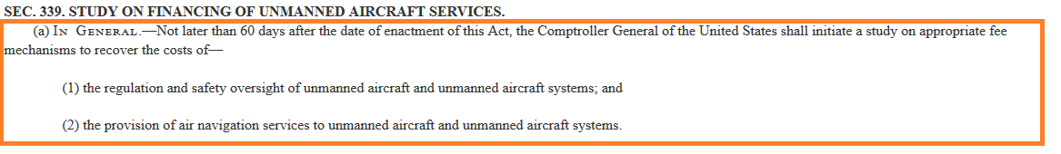
The 2018 FAA Reauthorization Bill also proposes new ways of financing a “safety oversight” mechanism and an air navigation system. This Bill proposes that the Controller General of United States conduct a study to gauge whether it is appropriate to levy an additional fee on drone pilots.
This purpose of this fee is to facilitate safe drone operators. Is an additional fee really justified? Let us dive deep and look at the statistics. At present there are about 70,000 Part 107 registered pilots and 800,000 registered drones. However, the total number of unregistered drones in United States is far greater.
Now, if an additional fee is levied, registered Part 107 pilots shall be the ones who will have to bear this additional financial burden. It is likely that this fee shall be on the form of a tax. (In order to introduce an additional tax, the FAA needs to get an okay from the Congress.)
There is no denying the good intentions behind the proposed introduction of this additional fee – Building the infrastructure (read UTM) for safe flight.
But, why should registered pilots be the only ones footing the cost of this infrastructure? And considering FAA’s mammoth 16 billion dollar plus budget, isn’t this fee nothing but a drop in the ocean?
Sure. It is admirable that the federal government is attempted to regulate drone laws. Many state and local bodies are planning on introducing regulations. However, new drone laws and regulations are often introduced without conducting a proper study. Often local regulators have a poor understanding of how the drone industry works. Without knowing what you are regulating, can you really come up with sound regulations?
Will the 2018 FAA Reauthorization Bill Help Amazon Prime Take Flight?
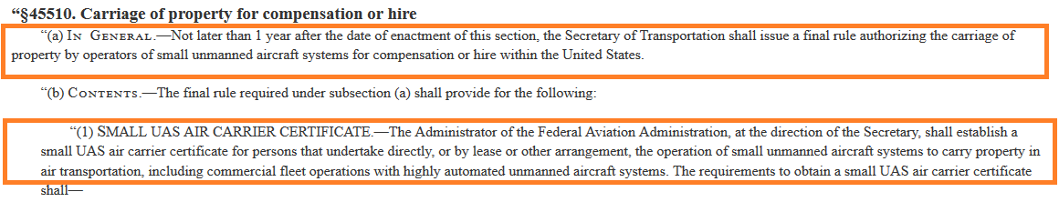
Section 45510 of the 2018 FAA Reauthorization Bill is clearly structured to permit drone delivery operations (Read Amazon Prime) to finally take flight. This Bill also proposes the requirement of air carrier certificate to carry property for compensation or hire. So, will this air carrier certificate create an entry barrier for the small guy? And will drone delivery operations become the sole domain of larger, organized players?
An air carrier certificate might mean the introduction of risk based guidelines. A payload limit is likely as well. (Delivering small packages via UAS is environmentally friendly and is commercially viable also)
Difficulty in flying BVLOS (Beyond Visual Line of Sight) and flying over people means that the future of drone deliveries is in a state of flux. Sour equations between Bezos and Trump are not helping the cause of drone deliveries as well. Check out my Medium Article, “Amazon Drone Delivery – Dream or Reality” to learn more about Drone Delivery Operations.
Will Sharing Samples of Approved Waivers Help Expand Drone Operations?
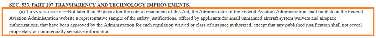
In its bid to make the system more transparent, the 2018 FAA Reauthorization Bill proposes the sharing of approved Part 107 waivers. This could prove to be beneficial to the UAV pilot. Right now the FAA does not have a systemic approach for granting waivers. Sharing an approved waiver will level the playing field. Currently the approval rates for Part 107 waivers are abysmal. Sharing samples of approved waivers should help address this problem, and hence help expand drone operations. This is another snapshot which highlights the FAA’s willingness to grant more waivers.
Conclusion
The 2018 FAA Reauthorization Bill has its shares of pros and cons. The proposed levy of additional fees on drone pilots does not make sense. Considering the huge capital requirements for UTM, this is but a drop in the ocean. So, while the intent is noble, there is a need to come up with an alternative funding solution.
Likewise, there needs to be more clarity with regards to the issuance of an air carrier certificate. Proposed requirements for a carrier certificate should not result in drone deliveries being the sole domain of larger players. And lastly, sharing approved waivers is a step in the right direction. It could result in greater transparency, and help expand drone operations.
Check out our Medium page for more such content
Do not forget to subscribe and Listen to Ask Drone U, the #1 drone podcast
Connect with a vibrant drone community by becoming a Drone U member
How to Make Data Driven Decisions in Agricultural Drone Mapping
Understanding NDVI Mapping, False NDVI and Importance of Radiometrically Calibrated Data….
World population is expected to touch a mammoth 9 billion by 2050. This rise in population means that we have to look for newer and more efficient ways to feed the planet. World Resources Institute estimates a 23% increase in livestock needs between 2006 and 2050. Whereas, beef and mutton requirements will increase by 30%.
This population rise will place greater demands on agriculture. Greater demand for meat will necessitate planting more seeds to feed cattle. There is a need to increase agricultural yields and use resources in the most efficient ways possible. Of course, we have been aggressively addressing this need. According to World Bank, percentage of population employed in agriculture has decreased from 43.28% in 1991 to 26.48% in 2017. Agricultural output has seen a tremendous rise in this same time-frame. This can be attributed to significant technological advances.
Drones can play a huge role in bringing about more efficient farming practices. Using drones it is possible to implement variable rate technology (which results in the optimum allocation of resources). PWC predicts a market size of 34.2 billion for commercial drone applications in agriculture. This is second only to infrastructure.
In this blog post I discuss NDVI mapping. How do you use NDVI mapping to assess plant health. I also discuss False NDVI and lay out the reasons for absolutely avoiding it. How can you pick the right camera sensor for agricultural drone mapping? What is the importance of using radiometrically calibrated data? These are some of the questions that I dive into. Read on.
How Does NDVI Mapping Work?
NDVI is Normalized Differentiation Vegetation Index.
The human eye sees all plants as green. That does not mean that all wavelengths are being absorbed. Some wavelengths that cannot be seen by the human eye are being reflected. So if you are a UAV pilot taking up NDVI mapping jobs, you need a sensor capable of making this differentiation. You need to determine the precise amount of light that is being reflected (more on this later).
For this, you will have to use a camera that can make this differentiation and hence, weed out the unhealthy plants from the healthy ones. Subsequently you can make actionable insights that will help the farmer allocate his resources in the most efficient way possible. If you use a camera that is not built to understand light, you might end up making wrong recommendations to a farmer.
Folks who use a non-IR cameras offer, what is popularly known as “False NDVI” services. Using a normal camera for assessing plant health is a bad idea. Using False NDVI, you are unable to separate red and near infrared light. This leads to wrong data and incorrect decisions which ultimately proves detrimental to crop health.
Why Ndvi Mapping Is so Useful for Farmers
Let us attempt to understand why NDVI mapping is critical for decision making in agriculture.
NDVI = (NIR – Red) / (NIR + Red)
So, we see all plants as green. However, along with green light, plants also reflect Near Infra-Red light. As you can determine from the above formula, NIR value is directly proportional to NDVI value.
Healthier the plant, higher the NIR value. Vice versa a dead or diseased plant will have a lower NIR value. NDVI value for plants ranges between 0.1 and 1. Non plant surfaces have a high red value and their NDVI falls between 0 and -1.
Using NDVI mapping you can created a color coded map that clearly shows diseased areas. Thus data driven decisions can be made quickly. And wastage of resources can also be avoided
How to Pick the Right Camera Sensor for Agricultural Drone Mapping
Parrot Sequoia and MicaSense RedEdge-M manufacture sensors that are purpose built for agricultural applications.
The Parrot Sequoia+ comes with a sunshine sensor as well as a multi spectral sensor. Because the amount of reflected light from crops tends to vary quite a bit, mapping results are prone to distortion. To address this potential issue, a sunshine sensor is fitted on top of the drone. This sensor records sunlight in the same spectral bands as the multispectral sensor.
The multispectral sensor mounted on the bottom of the drone in four spectral bands – red, green, the red edge and near infrared.
When using a drone for agricultural applications, it is imperative that your camera is radiometrically calibrated. This permits you to make empirical judgements that can benefit the farmer. Why is this necessary?
Your drone camera measures “at sensor irradiance”. While the camera output is in the form of a Digital number or DN. In most cameras, mapping of irradiance to DN is not known. And this mapping or correlation tends to change with change in camera settings. Radiometric calibration should be performed for each band, for different camera settings and optics. It is critical that this mapping is utilized while performing vegetation indexation. If you do not use radiometrically calibrated data, you will end up supplying data which is computed off raw DN’s – inaccurate data with disastrous consequences.
Should You Use a Fixed Wing Drone for Agricultural Mapping?
You might need a fixed wing drone for agricultural mapping if you wish to cover larger tracts of land. A fixed wing drone can fly at greater speed. But you need to be careful while making this transition.
The faster you fly, the more you will have to spend on your drone camera. Flying at higher speed means that you need a camera with a fast shutter speed. Avoid using ND filters at high speed – this will result in blurry images. If you attempt to stitch together images with a high amount of blur, you will end up with a shoddy product.
Conclusion
You need to thoroughly understand the nuances of agricultural drone mapping before venturing into this field. Do not attempt to offer “False NDVI” mapping services. This is just a recipe for disaster. And ensure that you are equipped with the right drone and camera before you think of taking up agricultural jobs. If you plan on taking up larger jobs, it is better to opt for a fixed wing plane with a high end camera. Through drone agricultural mapping, you can, in your own little way help bring about food security.
Check out our Medium page for more such content
Do not forget to subscribe and Listen to Ask Drone U, the #1 drone podcast
Connect with a vibrant drone community by becoming a Drone U member


More on Hot Topics

