Drones in Construction – How Can They Help You Manage Time and Cost
How Drones are being used for construction site monitoring, volumetric assessments and creation of timelapses
Steve Jobs maniacal quest for perfection is one of the reasons behind Apple’s success. This philosophy has certainly permeated into Apple’s DNA. This was evident when Apple fired DPR Construction and Skanska, lead contractors for their prestigious Apple “Spaceship” campus. DPR and Skanska were not able to match up to Apple’s exacting standards. Now, DPR and Skanska are no novices – both have managed multi-billion dollar construction projects.
“Inability to match up to a client’s demands results in ballooning costs and expensive project delays. And if the differences cannot be ironed out, construction litigation”
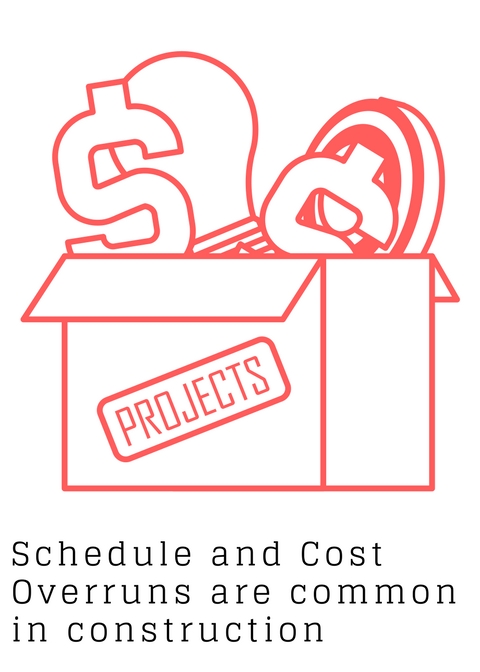
The Central Artery/Tunnel Project, popularly known as “The Big Dig” is perhaps, the most ill executed construction project in recent times. Originally estimated to cost $2.8 billion, project cost ballooned to $14.6 billion. Likewise the first capital expansion (North Terminal) at the Miami International Airport saw significant cost overruns and construction claims to the tune of millions of dollars – A massive waste of tax payer’s money. I agree that construction management is an extremely broad and complicated field. However drones can certainly help better manage these ever increasing client requirements.
“According to McKinsey, construction is among the least digitized among all industries. Maybe that is the reason that large infrastructure projects typically take 20% longer to finish”
In this blog post, I present some strong uses cases for drones in construction – site monitoring, quantity estimation and creating timelapses. Are drones cheaper and better than traditional surveying methods? How can drones help monitor a construction site? Why should you consider providing a time-lapse video as an up-sell to the builder? What are some FAA rules that are prohibiting the usage of drones in construction? Read on to find out.
How using drones for monitoring construction sites can facilitate better communication
McKinsey estimates that the construction industry loses $3 trillion annually. Design changes, scheduling mistakes and poor construction management practices can be attributed to this astonishing figure. Construction projects involve numerous stakeholders – owner, contractor, project manager, architects, site supervisor, structural engineer and more. The success of a construction project hinges on the ability of all these stakeholders to seamlessly communicate accurate data to each other.
Yes, photography can be used to monitor the construction progress. And with the advent of smart phones, this has become more prevalent. The problem, however arises when the project managers do not have a protocol in place to preserve this evidence. So, this is, at best a makeshift process.
Drones can address this problem by procuring accurate, real time data. Drones can be used to reach hard to reach areas also. This would be particularly advantageous while drilling an oil field, for instance. The project manager can comfortably view construction progress remotely from the comfort his/her site office. Using drones we can simplify the data collection process and also produce more accurate construction progression reports.
Using drones for accurate quantity estimations on construction sites
Let us explore a use case for estimating quantities and costs in construction. Let us say that you are a contractor planning on taking up an excavation + fine grading job for a large 10 acre site. What are your options? You can, of course, opt for a traditional approach by hiring a manned surveying team. Once you get this data, you can digitize it and compute take-offs using one of the many software available in the market. Using a manned surveying team is fast becoming an outdated concept – they take an insanely high amount of time to procure and process the data.
You should strongly consider using drones in construction for estimating quantities. If you hire an experienced drone pilot who has the right equipment to back him up, you can get survey grade data quickly and without breaking your bank. Coming up with the right client deliverable, however can be a challenge. Often clients want to run their own measurements. In order to do so, you will have to create a 3D point cloud with a mesh overlay. And you will need advanced mapping skills to do so. You can use Solid Works or Auto Cad viewer to view this mesh overlay. This depends on which tool the client is using.
Sophisticated clients use highly expensive GPS blade control technologies or machine control cost systems to do the actual excavation and grading work. They rely on RTK positioning. Machine control systems are manufactured by Trimble, Leica or Topcon.
“Accurate quantity estimations are critical – you need to know the amount of work involved. Using a combination of drones and GPS blade control can enable you to accurately estimate your project profitability”
Some of the biggest mining companies in the world were able to estimate their stockpiles inventories to 2-5% accuracies. Refer this link to learn how using photogrammetry and Pix4D, you can achieve this high level of accuracy for random shapes like stockpiles also.
Marketing Tip – Shoot a Great construction hyper lapse with your drone
Shooting a Contruction Hyperlapse can work to your advantage. You are not really putting in any extra effort since you are taking advantage of the time that you have on the site. A well shot and well edited hyperlapse is of great value to the client – It greatly helps market the property.
Editing a timelapse is tricky. Bear in mind that every day of your shoot is going to be different. Because the sun light is different in every image, the exposure values are different. If you attempt to stitch together images with varying exposure, you will end up with a shoddy product. To counter this, you can consider shooting on slightly overcast days.
Factors inhibiting the usage of drones in construction
Bear in mind that you might need permits if you are shooting an infrastructure project. If you do not factor in cost of the permits as well the opportunity cost (time taken to procure permits can be significant), you might end up losing money.
High rejection rates for Part 107 waivers is another factor deterring the usage of drones in construction. This makes it difficult to monitor large construction job sites. Lifting the line of sight restriction, for instance will make UAS operations cheaper – the need to reposition the equipment will be negated.
Another factor inhibiting the usage of drones is the highly prohibitive cost of LiDAR. Using photogrammetry is not advisable for topographic mapping of a tract of land covered with dense vegetation. You need LiDAR equipped drone for this. Using LiDAR enables you to cut through the dense vegetation and give you an accurate depiction of earth’s line.
Conclusion
Drones can be a cost effective and accurate way of preventing scheduling and cost overruns for construction projects. Annual leakages estimated at $3 trillion and extremely low levels of digitization means that the construction industry is ripe for the rapid adoption of UAV technology. Better FAA drone rules and more affordable technology will go a long way in increasing the usage of drones in construction.
Check out our Medium page for more such content
Do not forget to subscribe and Listen to Ask Drone U, the #1 drone podcast
Connect with a vibrant drone community by becoming a Drone U member
Drones in the Oil and Gas Industry – What Is the Reason Behind Their Rising Usage?
How drone usage is resulting in better data, improved safety and reduced costs
The oil and gas industry holds immense potential for skilled UAS pilots with high end equipment. Oil and gas companies do not have skilled personnel to conduct these aerial inspection jobs. So, drone services are typically contracted out to drone service companies.
Reduced human intervention, accurate risk assessment and significant cost savings renders drones as the technology of choice for this industry. However, you need to be acutely aware of the high skill and huge capital requirement before you think of venturing into this field.
In this blog post, I consider the various ways in which drones can be used in the oil and gas industry. I also discuss some drone and cameras which are being used for oil and gas inspections. Do you need a fixed wing plane to conduct oil and gas inspections? Do you need a thermal camera? Or, would an EO camera suffice? Read on to find out.
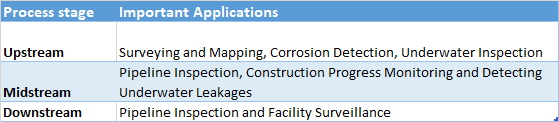
Drone Applications in the Oil and Gas Industry
I have divided drone applications into 3 buckets: upstream, midstream and downstream. Please refer the below table:
 Drone Applications in the Oil and Gas Industry
“The Impact of Drones comes in the form of speed, risk mitigation and savings”
Drones have applications at every stage of oil and gas exploration. The first stage is surveying. Traditional surveying methods can often take too long. This can result in project delays and ballooning costs. You can collect accurate survey grade data at a much faster rate using drones. Hard to reach areas are easier to access. This can result in significant time and cost savings. Once construction commences, work progress can also be monitored with ease. The project manager can monitor progress in real time from the comfort of his site office.
Pipeline connections run for hundreds of miles between the oil rig and the refinery. Wear and tear resulting from hostile weather conditions or poor construction render regular inspections a must. Drones can be used to spot gas or oil leakages. Corrosion and heat spots can also be detected. This helps prevent leakages and hence, mitigate risk.
At the downstream stage, drones are being used to prevent a facility shut down. For instance, refineries burn off waste gas to produce more useful material. Inspecting such flame stacks is required by industrial regulations. Needless to say, this task is fraught with risk. By using drones, we can remove human intervention and also produce far more accurate data.
Drones and Cameras for the Oil and Gas industry
As I pointed our earlier, there are many potential applications of drones in the oil and gas industry. It is important to accurately assess your client requirements and your deliverable to zero in on the right equipment for the job. Let us discuss some options.
Because the DJI Matrice series offers greater flight time and larger payload capacity, it is being used by many catering to the oil and gas sector. You can also fly an EO camera and thermal camera at the same time, if required. You can fly the FLIR XT 640 camera which is compatible with Matrice 100, 200 and 600.Or, you might have to go really high end depending on your application.
 Advantages of using a Fixed wing airplane for oil and gas
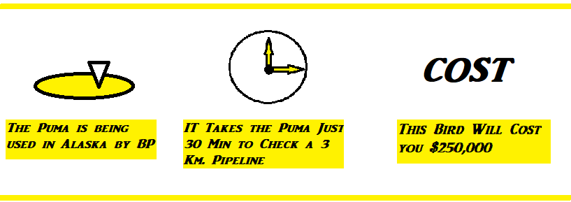
In 2014, BP became the first company to receive permission from the FAA to conduct commercial UAS operations over US land. This is for their Prudhoe Bay oilfield on Alaska’s North Slope. BP is flying the Puma AE UAV, a fixed wing airplane. Equipped with LiDAR, this fixed Twin airplane can check a 3 km pipeline in 30 minutes. Using traditional means would take 7 days to complete this same task.
The cost of Puma AE UAV? $250,000.
Recently the Silent Falcon was used to conduct oil and gas inspections in New Mexico. The purpose – visual inspection and detection of leaks. The falcon is a magnificent bird with a wingspan of 4.4 m and flying range of up to 15 km. And it is not cheap as well. This UAV comes with a hefty $250,000-$300,000 price tag.
Photogrammetry can be useful for monitoring construction progress. You can also detect spills and leakages using an EO camera. But if you wish to detect hot spots and other areas of potential risk, you will need a thermal camera. You can also detect leakages in underground pipes using a thermal camera. The surrounding area would heat up due to this leakage.
Conclusion
The oil and gas industry is a high margin, high industry. You need high grade equipment and a skilled organization to take up these jobs. If you are able to create these capabilities, the potential is immense. Sky-Futures, a company inspecting oil and gas rigs recently managed to raise $5.7 million from interested investors.
Do you have the financial and technical capabilities to venture into this field? Would you enjoy working in remote and lonely locations? Do you have a way of marketing your services to oil and gas companies? These are the questions that you need to ask yourself before you venture into this lucrative but complicated industry.
Check out our Medium page for more such content
Do not forget to subscribe and Listen to Ask Drone U, the #1 drone podcast
Connect with a vibrant drone community by becoming a Drone U member
How to Break into and Find Lucrative Opportunities Within the Drone Industry
Introduction
As per FAA’s 2017 Administrator’s Fact Book, the total number of UAS registrations are fast approaching a million. 70,000 remote pilot certificates were issued in 2017. So while there is no denying the steady demand for UAS services, supply of pilots is more or less keeping up with this demand. This has resulted in an intensely competitive environment and downward pricing pressure on drone services. So, in this scenario it is important for UAS pilots to have a sound business strategy in place.
In this blog post, I provide various tips to break into the drone industry and then gradually build up a steady and profitable drone business. Which drone jobs should beginners go after? Should you take up drone jobs through websites? Which are the most lucrative drone jobs? Read on to find out.
How to Break into the Drone Industry
Broadly speaking, drone jobs fall in one of the two categories:
- Volume-based, low margin jobs
- High Margin jobs
There are many folks who take the volume based approach and are able to make a good living. However, this is significantly more hard work. Sure. If you are a new entrant in the drone industry, you SHOULD target the low-hanging fruit. For beginners, taking up easy, real estate jobs is a great way of learning industry processes and beefing up skill-sets.
However, treat this as a stepping stone to bigger, better and more value added work. Consider this. Why make $25 an hour when you have the opportunity to make $350 an hour?
Is it wise to work for drone pilots to work for a company or as a contractor?
Websites such as DroneBase and Uplift have a ton of simple real estate jobs. While you can get a steady stream of work, you will not be able to make much money off these jobs. These companies/websites are protecting their own margins. And, the demand-supply mismatch is also quite skewed in favor of these organizations. It is easy for them to find folks willing to take up these low paying jobs.
Moreover they have strict contracts in place. For instance, pilots are often forbidden from handing out their business cards to companies while working as a vendor. However, once the job is over, you CAN get in touch with these clients.
Companies and corporations are hiring drone pilots for as low as $35,000. So at best, you should treat this phase of your career as a paid internship – a stepping stone to bigger and better things.
So, while you can consider working for a company or as a contractor initially, it would be wise to eventually set up your own independent drone business. You need to be more than “just a drone pilot” in order to run a successful drone business. You need to have the skills to fly in bad weather. You should be able to handle any maintenance issues. Remember – good pilots have a system in place and they follow it to the T.
How to make the most money with your drone
At a later stage, once you have built your skill-set, it would help to classify job types as follows:
- High maintenance, High margin jobs
- High maintenance, Low margin jobs
- Low maintenance, High margin jobs
- Low maintenance, Low margin jobs
So, typically you would be starting out with a low maintenance, low margin job. Like shooting photos for realtors. Or, maybe a wedding shoot. The most lucrative job type? The low maintenance, high margin jobs. You need to be an extremely good pilot to take up these jobs. These are the jobs that can be shot with entry level equipment and pay really well. For instance, power-line inspections. A Phantom 4 Pro is sufficient for this job. And you will need to buy a spectrometer. But when you consider the ROI, it is an extremely attractive proposition.Bear in mind that power-line inspections are incredibly difficult. And if you go wrong, the repercussions are huge.
Which are some of the other lucrative drone pilot jobs? Shooting action sports will also pay you really well. Likewise, luxury hotels and resorts can be a lucrative market too. If you stay in Texas or Iowa, you might have a windmill farm close by. Windmill inspections is another segment that you can consider. Typically, you can earn $350-$400 per inspection.
You need high grade equipment to execute the high maintenance, high margin jobs. So, if you need to map large tracts of land, you might have to opt for a fixed wing drone equipped with LiDAR. Entry level equipment for such jobs will set you back by $25k – $30k. And well, sky is the limit.
Conclusion
You can certainly make a great living as a drone pilot. But you need to strategize and channelize your energies in the right directions. Always aim for the difficult jobs which call for greater creativity and a higher skill set. Once you have built up your skill set, have confidence in your ability and the value that you provide. And learn to articulate your value proposition to your clients and prospects.
Running a drone business can be extremely rewarding. But you need to be creative, dynamic and persistently hard working to reap these rewards.
Equipment for Starting a Commercial Drone Business
According to estimates, rising demand from commercial and civil sectors is likely to propel the drone business to a $100 billion opportunity by 2020. As this industry grows by leaps and bounds, drone equipment has become cheaper and better. So, what is the basic equipment for starting a drone business? In this blog post I discuss your options for drones, cameras and accessories. Your most important equipment is of course, your drone. You choice of drone depends on the type of jobs that you plan on taking up. Your flying environment is another factor that affects your choice.
Are you planning on catering to the real estate sector? Do you want to shoot weddings? Do you plan on taking up mapping at a later stage? Or, maybe do pipeline inspections once you build up your skills? Do you need to fly in windy conditions? These are the questions that you need to ask before your make your equipment purchase.
DJI’s Phantom 4 Pro – The Best drone for the Money?
DJI’s Phantom 4 Pro is arguably, the most popular drone if we consider first time drone buyers. The Phantom 4 Pro is small in nature but very versatile. Because of its compact nature, the P4P is easy to travel with. It has the same 21.2 MP sensor that is present on the X5S camera which comes with the Inspire 2. For mappers, the ability to get into point of interest mode is a huge advantage.
What are some of the other big advantages? Presence of attitude mode is a huge benefit. You can control the drone better. It is easier to get buttery, smooth footage. The ability to shoot 4K is another huge plus.
Another huge consideration is cost. You can buy 3 Phantom 4 Pro’s for the money that you spend after an Inspire 2. You can also insure your P4P by enrolling into DJI Care Refresh for an affordable $300 per year. So, the P4P is ideal for folks entering in the drone business since it is cheap and easy to replace.
So, does the P4P have any serious limitation? Well, an inability to fly in windy conditions would be deterrent for some folks.
Inspire 2 – Is it worth it?
The Inspire 2 is ideal if you want to fly in cold conditions. Why? Because of features such as high altitude props and self-heating batteries.
Another factor that works in favor of the Inspire 2 is its build. What do I mean by that? Because most of the weight is distributed way below its lifting surface, the Inspire 2 flies like the pendulum. For the P4P, weight is distributed right below its lifting surface. This enables the Inspire 2 to snap into safe flight faster than an Inspire 1 or P4P.
Greater wind handling capacity, better payload capacity and more flight time are some more advantages of this bird. Longer flight time can be attributed to battery redundancy – you can fly with 2 batteries. Moreover, Inspire 2 batteries have a compact build and hence, are easier to travel with.
The Inspire 2 comes with dual compasses and dual IMU’s. For mapping applications, the Inspire 2 is a better alternative than the Inspire 1.
How does the Phantom 4 Pro compare to the Inspire 1 and Inspire 2?
Flight control on the Inspire 1 is superior as compared to Inspire 2 also. Another area where the Inspire 1 scores over its successor is durability. The Inspire 1 is likely to last you longer.
The fact that DJI Go 4 on the Inspire 2 changes settings every time you insert a battery is another disadvantage. This is to factor in the multiple updates. Because the Inspire 1 comes with the older App, settings are retained on this bird.
Another issue with the Inspire 2 is priority control. Roll and pitch are given priority over elevation and yaw. So, if elevation and pitch are hit at full forward, the Inspire 2 will prioritize pitch over elevation. So, if your rise over run will leave a lot to be desired.
However, going full elevation and full forward pitch on the Inspire 1 will result in a nice linear elevation. Rise over run is going to be perfect. So, it is likely that you will have to redo more shots in the Inspire 2 as compared to the Inspire 1. All in all, you will get a lore more flexibility and shots with the Inspire 1 as compared to the Inspire 2.
The Phantom 4 Pro is the best drone for the money. It gives you the best bang for the buck. If you are looking for flexibility and good flying capabilities, opt for the Inspire 1. As far as the Inspire 2 is concerned, you will get a powerful bird with multiple redundancies. You can fly in extremely windy conditions also. But be prepared to fork out a lot of money.
The best cameras for your drone business
Let us talk about cameras now. Owning a bigger bird like the Inspire 2 gives you the ability to fly bigger cameras. This is because of a higher payload capacity. For instance, the X5S is too big for the Inspire 1. You simply do not have the smoothness and control that you have when you fly an X3 camera. However, the Inspire 2 flies the X5S just fine.
If you are looking for a good entry level camera which can shoot 4K, the Sony A6300 is a great option. This camera gives excellent results in low light as well. An ability to shoot great Slo Mo footage is another advantage. You can buy the full kit for around $2,000. The only difference between the A6300 and its successor, A6500 is the presence of touch screen.
If you need a camera with good zoom capabilities for your Inspire 2, you will have to opt for the Z30. And at $10,000, the Z30 is not exactly cheap. For search and rescue, the M100 with Z30 is an alternative. If you wish to fly weddings, you can consider opting for the 12 MP Zenmuse Z3. Because flying over people is not permitted, the only workaround is to get a camera with good zoom capabilities.
If you are planning on taking up industrial inspection jobs, you might have to opt for the M600 with a Ronin and a Canon 50 MP camera.
And do not forget these important accessories….
Apart from your drone and camera, you will also have to invest in some accessories. Buying a high quality professional case will ensure that your bird and camera are well-protected. Go Professional Cases are a great option for high quality custom cases. Wear a hardhat and vest while you are out on the field. Always carry some spare batteries and props while on a job. Using a landing pad will help prevent unexpected damage to your drone.
Conclusion
It is critical that you careful evaluate your requirements and consider your budget before purchasing equipment. What are my client requirements? Do I have the necessary skills to execute a job? Do I need to fly in windy conditions? Can I build a sustainable stream of work to justify this purchase? These are the important questions that you should ask yourself before purchasing your equipment.
If you do not budget constraints, you can consider going high end and purchasing a larger bird and better camera with superior capabilities. This will certainly give you the ability to do more value added work.
How to Navigate the FAADroneZone
The FAA has rolled out a fancy new website, FAADroneZone to consolidate its UAS operations and information hub. Pilots can now check on airspace authorizations, register aircraft and report accidents all on one cloud-based application.
While this may seem like a major step forward for frustrated pilots who struggle to hear any word on certificates they’ve field for, it is a step in the right direction. Here are three things you need to know.
The FAADroneZone as much for the FAA as it is for the pilot
The FAA released its new portal to consolidate operations so that all of its UAS related filings could be managed in one place. This seems like a godsend for anyone working as a remote pilot. But it’s also equally important for the administrators.
The government agency was forced to react to a dynamic and rapid-moving industry, and instead of planning out a framework that made sense, it had to piece together a method for users to request authorizations and waivers for certain Part 107 operations.
There’s more to come
The current Drone Zone is only a framework, and is a platform that makes future expansion possible. This gives hope to even more efficient ways for both the FAA and UAS operators to conduct business more efficiently. With safety in mind, this is imperative. Currently, the number of UAS enforcements do not reflect the number of violations that take place on a regular basis in the commercial UAS space.
The FAA DroneZone will assist other agencies
When an airspace authorization is submitted in airspace related to a military base, the Department of Defense (DoD) is involved in the approval process. This means that the Drone Zone portal is a resource for it as well. In addition, the National Transportation Safety board examines all accidents involving manned aircraft. If one ever crossed paths with a drone, the new portal would give the Department of Transportation ample resources to investigate the background of the aircraft in a one-stop shop.
As it stands, the Drone Zone is not exactly what those clamoring for more efficient authorizations and waivers are looking for, but it’s a step in the right direction.
Michael Jones is an FAA-licensed commercial UAS operator and chief pilot of California Aerial Media based in San Diego, California. With 20-plus flight hours in single-engine manned aircraft and hundreds more logged in UAS, aviation is one of his true passions. In addition, he is an award-winning author whose work has been featured on sites such as Yahoo!, MapQuest, About.com and Vox Media among many other publications.
Check out our Medium page for more such content
Do not forget to subscribe and Listen to Ask Drone U, the #1 drone podcast
Connect with a vibrant drone community by becoming a Drone U member
5 Key Safety Tips for Professional UAS Operators
Working as a commercial UAS pilot is an adventure that will take you to many new places. Unfortunately, those places can sometimes be dangerous and unfamiliar. Even seemingly nice neighborhoods and communities can yield some sticky situations due to interactions with the people who live and work there.
Here are five ways a drone pilot can stay safe out in the field.
-
Know your surroundings
When working in an unfamiliar area, it’s imperative that you become familiar with your surroundings, and understand the best way to make a quick exit in case of an emergency. Always back into a parking spot whenever possible. And carry only the gear necessary in order to make yourself as mobile as possible.
-
Look the part
One challenge commercial UAS operators face is the fact that the general public gets nervous whenever a drone is in the air. What’s worse is that once you are discovered as the pilot, you become a target for unwarranted criticism, hostility and at the very least, curiosity. Each of these elements can put you in an unsafe position, so it’s important to look like a professional.
You’ll carry much more credence if you’re in uniform that looks official. A safety reflective vest is perhaps one of the best tools for accomplishing this effect. In addition, utilize cones to cordon off your areas of operation. This will make it clear to the public that you are not out for a playful afternoon, but instead are a working pro.
-
Be civil with others
When you do get into a confrontation of any type, treat everyone with courtesy and respect. Have empathy as if you didn’t understand what was happening as you watched a drone fly overhead. Media coverage of UAS operations tend to focus on what’s negative. Instead, be a beacon of light and treat others nicely. You’ll usually get that same respect in return and avoid a potential hostile situation.
In a hostile situation, carrying the Drone Pilot Field Kit will help you immensely. Carrying this kit will help convince hostile folks that you are well within your legal boundaries.
-
Use the buddy system
If an area makes you uncomfortable or uneasy for any reason, bring a colleague if at all possible. This way, the Visual observer can keep an eye out on your drone and surrounding environment as you pilot the aircraft. If there’s any sign of danger, then it will be far easier to avoid it with another set of eyes.
In fact a bigger production house will pay you a separate labor rate. This is meant to cover your expenses for hiring a VO. And, even if you are not being reimbursed for your VO expenses, hiring a VO shall not cost you more than 10% of what you make.
-
Have a communication plan
Let others know where you are, and make it easy to contact someone should things escalate quickly. Always make sure your cell phone battery is charged and you have it within reach. Plan to check in with someone who knows where you are at regular intervals. At the very least, get in and get out.
Conclusion
Adopting the above common sense measures will go a long way in ensuring safe flight. Public perception will often be against you. But, being methodical will help you deal with this hostility.
Think of the worst situation that you can get yourself into. Ask yourself, “Which are the tools that will help me deal with such situations?” How can I prepare myself mentally to deal with such situations? And remember to always, always be civil even with the most hostile folks. Following the above tips will certainly help your cause of building a sustainable drone business.
Michael Jones is an FAA-licensed commercial UAS operator and chief pilot of California Aerial Media based in San Diego, California. With 20-plus flight hours in single-engine manned aircraft and hundreds more logged in UAS, aviation is one of his true passions. In addition, he is an award-winning author whose work has been featured on sites such as Yahoo!, MapQuest, About.com and Vox Media among many other publications.
The Uniform Law Commission And The NAS
As U.S. based drone pilots and operators, we are able to enjoy responsible flights in just about the entirety of the National Airspace System (NAS).
For now.
If the current Uniform Law Commission’s (ULC) committee working on the “TORT LAW RELATING TO DRONES ACT” has its way, we could very likely lose 25% of that airspace.
And a very familiar name (who is not a friend to drone owners) has a very prominent position on that committee. And he is there wearing his Pepperdine University Law Professor hat instead of his AirMap Co-founder hat. We are speaking of none other than Mr. Gregory McNeal. This author finds it very interesting that Mr. McNeal is there under the Pepperdine banner and not the AirMap banner. Maybe it’s because AirMap stands to make quite a bit of money if this Act passes and he doesn’t want to appear to have a vested financial interest in the outcome of that act. But that’s purely conjecture.
More on that in a bit.
Some of you may be familiar with AirMap’s previous skirmish with the UAS community when it came to light that they were supporting Senator Feinstein’s Drone Federalism Act (SB1272, 2017). AirMap’s hired lobbyists not only supported the bill financially, they actively lobbied other legislators to vote for it. At least that’s the presumption, given emails sent to some in the UAS community by Senators who don’t agree with Ms. Feinstein’s bill. SB1272 text can be found here.
That Act, if passed, would give control of the first 200’ of the NAS over to local legislators. That act currently sits in the Senate’s Committee on Commerce, Science, and Transportation. It’s been there since May of 2017, and given Senator Feinstein’s fall from grace within her party, it’s unlikely to be advanced out of committee. This is a very lucky break for drone owners, whether they fly under 101/336 or 107 rules. If passed, it could have given political subdivisions the ability to shut down commercial and hobby drone operations in “their” airspace. That would have effectively killed the commercial drone business in those locales.
Luckily that act now seems to be stuck in bill purgatory. And we as a community should do all in our power to make sure it stays there.
So let’s talk about how SB1272 coincides with the ULC Committee’s work on the tort law act.
How passage of the Tort Law Act will severely limit our airspace
Section 501 of Tort Law Relating To Drones Act is titled AERIAL TRESPASS USING AN UNMANNED AIRCRAFT.
Until this point in our history, there has not been an easily defined legal criteria for a charge of Aerial Trespass. There have been a number of court cases that define it in certain instances, but those are very limiting, and can’t really be used to give a standardized legal definition in other cases. The Tort Law Relating To Drones Act, as currently written , will put into play a very easily defined legal definition of Aerial Trespass.
It states very clearly what that definition would be: “(a) A person operating an unmanned aircraft is liable to an individual for trespass, if, without consent, the person causes the unmanned aircraft to enter into the immediate reaches of the airspace above the land of another.”
On it’s surface, this seems unobjectionable, but in order to understand the magnitude of what this would do to the hobby and commercial drone communities, we need to look up “immediate reaches”. We don’t have to go far to find that definition. The authors of this Act were kind enough to provide that for us.
Under Section 102. Definitions, they include “(5) Immediate Reaches”. This is defined as the airspace from ground level to at least [100] feet above the surface, or where surface improvements are present, the airspace at least [100] feet above those surface improvements.”
Think about that. And that’s “at least”. Which means cities and states have the ability to increase it if they want.
If you are flying in an urban area, you would not be allowed to fly over any residence or property at an altitude of 100’ or less (above any improvements) without the fear of being cited for Aerial Trespass.
Now again, on the surface, this may not sound too limiting. But let’s put a real world drone spin on it.
If you use a drone for real estate photography and videography, you find yourself routinely flying below 100’ above improvements on adjoining property. Insurance and inspection flights routinely fall under that same demand. Neither of those UAS disciplines can effectively do their jobs if they are limited to being 100’ or above adjoining property improvements.
And those are just two examples. There are plenty more.
Current aerial trespass doctrine is, “Flight by an aircraft in the air space above the land of another is trespass if (1) “[the aircraft} enters into the immediate reaches of the air space next to the land, and (2) [it] interferes substantially with the other’s use and enjoyment of the land.” The ULC committee feels this definition is problematic because “there is no existing right to exclude aircraft from flying above one’s land without showing interference with use and enjoyment of the land.”
They also are trying to make it sound like they are doing the UAS communities a favor because “this will likely prove problematic as it will require a fact-specific showing related to each overflight before an unmanned aircraft could be excludable, leading to uncertainty and lack of uniformity.”
The committee feels if there is a legal definition of 100’ as “immediate reach”, it will make our jobs easier because we’ll have the uncertainty of where we’re allowed to fly removed from the equation.
This can’t be further from the truth, and smacks of behind the scenes activity with zero input from the people this will directly affect. It appears Mr. McNeal does have a Remote Pilot Certificate (at least someone with his name does), but apparently none of the other representatives do. There are two members with names too common to check, so that is also a possibility. But if Mr. McNeal is the only one “representing” UAS owners, we’re screwed.
While I commend Mr. McNeal for getting his 107RPC, I’d like to see someone on that committee who uses their 107RPC to make money with, not someone who uses it to make money from. There is s difference.
Why does the history of Mr. McNeal seem to suggest that he wants to drastically limit where drone owners can fly? And we’re not even bringing up www.noflyzone.org. Do a bit of research on that failure. But it was his first attempt at restricting our rightful access to the NAS.
To answer that questions, we need to look no further than the company that Mr. McNeal founded with Mr. Ben Marcus: AirMap.
How Airmap stands to gain at the expense of the entire drone community
AirMap is a company that has developed an app that allows UAS operators and pilots to see if they are in a safe area to fly. Very commendable. And their product is awesome. It’s the backbone of DJI’s GEO System. I don’t use it (I use Skyward, and KittyHawk once it comes on line), but those who do seem to like it very much.
But behind that is AirMap’s desire to work with states and localities to implement Unmanned Aircraft System Traffic Management (UTM). More info here.
UTM is a great idea, and in practice will make the skies safer. However, if done incorrectly, or with undue influence from company’s that will directly benefit from its implementation, it can and probably will lead to a pay to play system. There you will have to subscribe to a service before you can fly in certain airspaces. In other words, pay the subscription or not fly there. Even though we have that right currently.
AirMap already has their foot in the door in Kansas.
If McNeal and Marcus end up being the chosen UTM provider for the other 49 states, they stand to make a ton of money. And there is nothing wrong with that. It’s the American Dream. It shouldn’t be at the expense of an entire industry.
When they stand to make that money on the backs of an industry they publicly profess support for, their words becomes very disingenuous.
You have to ask yourself why a company would actively be trying to make it harder for UAS owners to fly in the U.S. Especially if that company is supposedly working with us, in order to gain quicker access to the NAS in restricted areas. Are you working for us, or against us AirMap?
These actions seem to speak volumes about the seemingly true intent of their business model. It’s about making money, not keeping the NAS safe, or tenant/homeowner privacy.
Given the track record of the founders of AirMap, I strongly suggest that UAS owners, both 101/336 & 107, keep a very close eye on this committee’s work. If it continues down this path, keep your Congress Critters informed of what will happen if the Uniform Law Commission’s Tort Law Relating To Drones Act is put into law.
In Conclusion
To sum it up, there is no reason for this committee to even be meeting. There are plenty of laws already on the books that would address these issues. And there is already SCOTUS law in place to protect homeowners and tenant privacy. The only viable reason for this law to is create a “pay to fly” system. And that flies (pun intended) in the face of our freedoms as UAS owners. This is NOT a safety issue at all.
It is imperative that the entire UAS Community keep a close eye on this committee and let them know that their plans will drastically affect our ability to enjoy our hobby, as well as perform our jobs.
If you would like to be added to the email list keeping interested folks informed, please email, and ask Ms. Grelle to add you to the TORT LAW RELATING TO DRONES ACT list.
~Vic Moss (Owner, Moss Photography)
Check out our Medium page for more such content
Do not forget to subscribe and Listen to Ask Drone U, the #1 drone podcast
Connect with a vibrant drone community by becoming a Drone U member
Drone U In-Person Mapping Instruction: A Comprehensive Course on Mapping and Modeling with sUAS
The trend of utilizing small Unmanned Aerial Systems (sUAS) for mapping and modeling of real world features is on the rise. This technology is being integrated across a vast number of commercial/industrial sectors. As integration becomes more prolific, the demand for training increases.
In this article I take a look at the ways sUAS operators utilize this technology to help fulfill demands across a variety of commercial sectors. So, where exactly is this technology being used? Using drone mapping in surveying (for creating accurate maps) and construction are not the only uses. Though these aforementioned uses are prolific and growing, the ways we utilize data in other areas is increasing and not apparently obvious. For instance, did you know that a sUAS can be used to map/model tropical resorts and coral reefs? Some other creative applications include mapping/modeling MLB stadiums and PGA golf courses.
Let us take a closer look at the final deliverables across these various applications. This will help us understand the approach that we at Drone U take when offering and teaching our mapping courses.
What Makes Drone U an Awesome Value Proposition?
![]()
There are a variety of different sUAS schools out there that that can teach you about data acquisition and processing. So, what sets Drone U apart? Our course is taught by the industry’s best with solid, real world experience.
Our goal is to offer a comprehensive course that covers all aspects of mapping and modeling with sUAS from acquisition, through processing and all the way into deliverables. With the latter area we go into great detail on how to market and price your services. Before we dive in to the various aspects of the sUAS mapping training course at Drone U we’ll begin by reviewing the various aspects of sUAS mapping.
How to Zero in on the Right Acquisition Technique for Producing GREAT Data
The most critical part of data collection is the acquisition technique. It’s very simple – without good data you cannot produce good results. You can make your data better through advanced processing techniques in Pix4D Mapper (P4DM). But you CANNOT get good results from bad data.
So, which acquisition technique should you use? To determine this, you should consider the type of deliverables that your client is looking for. We can break down deliverables into two basic categories – 2D (maps) and 3D (models). For 2D maps the common deliverables produced are orthomosaics, Digital Surface Models (DTM), contour data and Google KML maps. And point clouds and 3D meshes are the common deliverables for 3D output. Point clouds are the initial product that all other files and deliverables are based on.
To control the geospatial placement of the map/model in the real world, Ground Control Points (GCP) are utilized to tie a point in the mapped area into the local/world coordinate system using GPS data. During processing GCPs are imported in to the project. This not only helps properly scale the map/model but it also increases the absolute accuracy by orders of magnitude. In our course we cover various different GCP and GPS types as well as techniques for importation into the project.
How can Drone U Help you Refine your Processing Techniques?
Once all data is acquired, a processing engine is used to reconstruct the area that was mapped in both 3D and 2D. At Drone U we use P4DM which is an industry standard, scalable application developed by Pix4D. In the course we go into great detail into all steps and associated parameters within each of these steps. For instance, with complex models like a baseball stadium we will use three or four different data acquisition techniques. These include standard or double grid mapping missions, inner and outer orbital missions, and free flight.
Generally speaking, the processing engine cannot process all of the data together at once. So sub-projects are required. To ensure proper merging of the sub-projects, Manual Tie Points (MTPs) are added to each of the projects. Apart from tying the sub-projects together into one large project, these MTP’s are also used to help clean up certain areas of the project. This is achieved by manually telling P4DM how to better match areas with less data or increased noise (these two being mutually inclusive).
Practical Insights that will Help you Build a Successful Drone Business
The last piece of the course is arguably, the most valuable. Here, you will get a chance to look at the various different file types that we produce with P4DM. You will also learn how these relate to client deliverables. We have a long list of how these maps and models can be used across different business sectors. And this list continues to grow as we recognize new ideas. We devote a good amount of time to help you understand this aspect. Additionally, we also explore how you can effectively market and price your work. In this piece of the course, you will receive practical business insights to turn your passion to profit.
Upcoming Drone U Offerings
Drone U is offering a number of upcoming trainings. Our next course is in Houston, Texas. If you are interested in being a part of a fun and informative experience, sign up here.
Do not hesitate to contact us for information on any current or upcoming classes. At Drone U, we also offer customized private courses for strategic corporate partners. If your company or corporation is interested in integrating sUAS mapping and modeling in-house, we can build a course to address your specific needs. Email us! We look forward to hearing from you.
~Doug La Farge (CEO, DT Aerial Photography LLC)
Check out our Medium page for more such content
Do not forget to subscribe and Listen to Ask Drone U, the #1 drone podcast
Connect with a vibrant drone community by becoming a Drone U member
How to Select the Right Mapping Application for Your Drone Business
Mapping and modelling is a lucrative sector for drone pilots. Along with good mapping skills you MUST learn how to provide a killer client deliverable. So, how do you generate useful and actionable maps? That is right – by choosing the right mapping software. So, which is the right mapping application for your drone business?
A wide variety of data platforms are available today. Pix4D, PrecisionHawk, MapsMadeEasy, PhotoScan and DroneDeploy are some of the popular options. We go through the pros and cons of each tool. Read on and learn to zero in on the right mapping software for your drone business.
Reviewing Pix4D: Capabilities and Limitations
Pix4D is the gold standard of mapping applications. You can create point clouds, object files, DSM’s, DTM’s and more using Pix4D. You can even upload your Pix4D projects onto the cloud. If you are doing cross hatching missions with a gimbal tilt, Pix4D yields great results.
Pix4D capture has one big limitation: its inability to fly bigger missions. Because you can use one battery, you will have to opt for alternative software while flying larger missions like mining or NDVI.
On bigger missions, the Yuneec H520 is a better option. Yuneec H520 comes with its own DataPilot system. Unlike Pix4D, you can continue to work on larger missions. Moreover, the Yuneec has superb wind handling capacity. Also, the JPEG’s produced through Yuneec’s DataPilot system have less tonal contrast and more sharpening.
Another drawback is the sub optimal client delivery mechanism. In Pix4D, you have to take a longer route and download an OBJ file to Sketchfab. Or, you can download an LAS file to point cloud to showcase to clients
Is DroneDeploy the Right Mapping Application for You? Not Always…
DroneDeploy is a cloud based tool that has its uses. DroneDeploy uses Pix4D’s cloud engine. It is a great option if you are planning on doing NDVI or volumetric measurements. Unlike Pix4D, DroneDeploy has an excellent client delivery mechanism.
A limitation of using this tool is that you can process no more than 2500 images. Thus, this application is not suitable for larger modelling projects. The quality of your map/model is going to be sub-par if you rely solely on DroneDeploy.
Pix4D and DroneDeploy Alternatives
PhotoScan by Agisoft is a great alternative to Pix4D. It has a cheap entry level option and is, by far the biggest competition to Pix4D. You can do basic photogrammetry using this application. You can also create a point cloud and 3D models. This software also comes with Fisheye camera support. PhotoScan is a great tool if you wish to wet your feet and understand how image acquisition works.
For larger and high-level missions, you can opt for Precision Hawk’s Lancaster drone. The Lancaster has the ability to fly larger missions. You can also use multispectral and hyperspectral sensors. They have an online client portal, an excellent way of helping the client visualize data. Note that there is no delivery mechanism for tools like MapsMadeEasy and DataPilot. The huge initial investment of $25,000 can be a deal breaker for many.
MapsMadeEasy is an efficient and cost effective solution. This application can be used on cross hatching missions with variable gimbal tilt. The Terrain Awareness feature comes in handy when mapping areas with large elevational changes.
Desktop vs. Cloud Mapping Application
We would tilt in favor of desktop based software. Cloud based software like DroneDeploy and SiteScan have their uses. But desktop based software is the go to solution if you wish to process voluminous data.
An inability to add in manual tie points is another disadvantage of cloud based software. Remember that having manual tie points increases the accuracy of your drone model. Another advantage of using desktop based software like Pix4D is the ability to make camera movements. The smoothness of camera movement depends on your computer power. This is not possible in cloud based tools.
Cost Comparison of Mapping Applications
Most mapping applications offer a monthly package. You can get a discount by opting for the annual package as well. The only option is MapsMadeEasy where you can avail a “Pay as you Go” option.
Most software offer free trials as well. For instance, Pix4D offers a 2 week free trial whereas PhotoScan offers 4 weeks free. Please refer the following cost comparison spreadsheet for your reference:
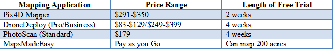
Cost comparison of popular drone mapping applications
Wrap Up
- Carefully evaluate pros and cons to determine a mapping application suitable for your business. Try out different acquisition styles: vertical, oblique, nadir and run them through the software. This is a great way of determining software capability and hence, suitability.
- Make sure that you take advantage of the free trials offered by various vendors. This is a great way of familiarizing yourself with the application.
- A desktop based application has greater capabilities as compared to a cloud based application.
- You need a dedicated computer for modelling and mapping. Running a mapping application is taxing on your computer processor. If you have a powerful computer, you can have more done in the trial phase.
Check out “The Ultimate Comprehensive Guide to Drone Mapping, Acquisition & Processing Software“.
Become a Drone U Member.
Do not forget to subscribe and listen to Ask Drone U, the #1 drone podcast on iTunes!
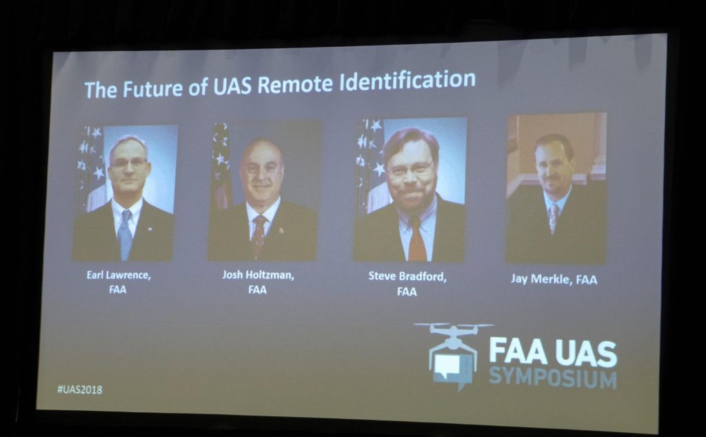
FAA UAS Symposium 2018
The FAA Is Further Behind in UAS Regulation Formulation but Is Open to Solutions…Sort Of
Discussing Remote ID, UTM, BVLOS Operations and Complex Waivers
The FAA has long struggled with catching up to new technologies. In the past, the federal agency has had more time to make decisions on rolling out regulations due to the pace of technology. Now, the pace of technology is so fast, the FAA is struggling to keep up. And the data actually shows us that we are further behind than we ever expected.
This past week I attended the FAA UAS Symposium 2018, the FAA’s conference to discuss the direction of the industry and help pilots understand the current state of the drone world. This conference showed us that while the FAA is really struggling to keep up with the technology as it grows…it is clear that the attitude of the agency has changed dramatically. But it has changed for the betterment of the industry. In the past, prior administrations would essentially give the impression of “let us figure it out, we got this.” This conference had a very different tone, the FAA really branded the concept that they’re willing to listen to the UAS community and want feedback from market players to advance the drone market as we know it today.
The only problem with the “we’re listening,” rhetoric is that the FAA could potentially be listening to the wrong audience. The FAA has prioritized the words and recommendations of the much larger companies rather than the small businesses. The small businesses that actually operate in the national airspace system, the guys who are owners and pilots. They’re not lawyers and strategists. In essence, the FAA’s decision to hear out the big whales makes sense as these larger companies have interests to develop systems that can vastly grow and scale their drone business in the market as we know it. They’ll save millions of dollars, create new jobs and increase efficiency. These aerial systems will also take significant infrastructure, example BNSF railroad creating control stations along their railroads for takeoffs and landings of fixed wing, BVLOS aircraft. (BVLOS: beyond visual line of sight).
Albeit the argument makes sense, it is necessary to beg the question, “Why not listen to the small business operators?”. Why not listen to operators that have real world experience in the field? The little guys represent about 95% of the 75,000 licensed drone pilots in the United States. The major players have the time and money to be patient and figure out how to implement autonomous, often times, long range operations with drones.
The big players can spend time and money to have an ear with the FAA, they have spent significant money just to have lobbyists pound pavement in Washington, albeit with little success.
(CNN took 2 years to acquire a “flight over people exemption,” spending hundreds of thousands of dollars to a max height of 21 feet and are required to use a tethered drone) wow……
Since 2016, when Part 107 was implemented, these large businesses have been hustling to waive certain sections of the law. If they can acquire an exemption from the FAA to operate beyond visual line site, or fly over people for news… then they can solve significant problems and offer new solutions to their clients & customers.
The only issue is that these large companies have time and money, what about the startups that would like to solve problems for other companies that are often unwilling to explore new solutions? Well, the FAA has successfully setup an environment where startups are often started with a pathway to failure if their operations fall into a waiverable category. They’ll be waiting years to complete simple operations that take place in other countries, all over the world, everyday. At what point is the FAA breaking its Congressional requirement to provide a pathway for integration of drones in the NAS?
Major Themes:
This conference covered a few major themes which would have a significant impact on the industry as a whole. One major theme is pushing Remote Identification on all UAS. Remote identification would be a requirement to all future operations. Remote ID would be used to broadcast a drone’s position so other aircraft and law enforcement have an idea of who’s flying what and where.
The FAA believes that Remote ID would provide a few simple solutions which could then multiply other solutions on the FAA’s end, and allow for more operations. Remote ID could be the system that allows for further growth in drone integration, and the safety of the National Airspace. In the eyes of the FAA, remote ID would allow for law enforcement to identify drones and their operators. In addition, it would allow all aircraft to view each other’s position in the NAS. It would also provide a way for remote pilots to always know the location of their vehicle, in the unlikely event of an accident.
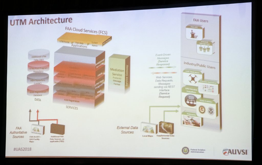
Remote ID would also become the first system to be implemented to advance the new UTM, or universal traffic management system that could be the quintessential key allow these larger autonomous operations of drones. Think amazon delivering packages, flying railroads for inspections, and mapping roads for autonomous cars. The FAA called UTM the “system of systems” to allow for autonomous operations, BVLOS operations, flight over people operations, and other unique operations that help businesses acquire data and solve problems.
During the 2018 FAA symposium, the FAA discussed the real need for Remote Identification or Remote ID on drones
Earl Lawrence did an astounding job of being open to solutions for remote ID. He and the other FAA officials made it abundantly clear that they wish to find a solution to remote ID in a cheap and efficient way, that wouldn’t add additional weight to existing drone systems. In addition to this pro-business mindset, the FAA stated that the only solution to this system would have to be a performance based standard. With performance based standards, if the technology accelerates, the system scales with it. That is commendable. Many of the whales (larger drone companies) offered systems and potentially theories of how remote ID could be implemented. Project Wing, a subsidiary of Google, offered a 5 step solution that would seem pretty simple. DJI, the world’s largest manufacturer of drones has a solution of its own. Currently, a majority of the systems they sell today could actually broadcast remote ID and even turn the data into a “TCASS like,” system. The current aircraft offered by DJI have the computing power to even communicate with one another. Does that mean DJI could flip a switch and boom problem solved?
For those aviators out there who aren’t familiar with TCASS, this system communicates position information to other planes and helicopters. This system also tells southwest airlines if another plane is on the same trajectory and the flight controller will automatically adjust its path to avoid collision. If DJI’s existing systems can already promote Remote ID, why not use them? It’s easy to believe that pilots are weary of their privacy and who sees the data. The FAA even said, on multiple occasions that they are getting into the data business. So who owns the data and who will have access to it? Many people are afraid remote ID would infringe on privacy, while others see it as a pathway to complex operations, as we can “see” who’s flying and where.
Drones have to be integrated into the national airspace system in a manner that allows for scalability for autonomous operations
Do you notice if common theme here? Businesses are investing millions of dollars to figure out what the government should have already figured out, but the fact that the FAA is proposing these regulations and asking for feedback is outstanding. . Think about it, DJI released a Remote ID system late last year in Washington D.C. They also displayed a system (Aeroscope) for law enforcement to view the remote ID of any drone. This expensive system works well in determining rogue drones from authorized flights. Although any tech savvy millennial would tell you to spend $150 on a large wifi antenna and kismet to acquire the same data….
Many industry leaders I spoke with believe that remote id is the key to widespread access to exemptions and new opportunities.
Waivers and Exemptions (aka the same thing and the true gateway to expand operations)
In the eyes of the FAA, Remote ID could open the door to the system of granting waivers more easily and efficiently. Therefore allowing for many more operations that would require specific regulations to be waived. Under part 107, drone operators have to stay line of sight, below 400 feet and cannot be flown over people. While there are more regulations than just that, I’m limiting the discussion to those for the sake of keeping this article short. The information below detail just how many people have applied for specific regulations to be waived, and how many individuals have been successful in obtaining these waivers or exemptions. These exemptions would allow pilots to offer more services, and more easily scale those services.
Looking at the rates of approval versus denial is pathetic. The number of BVLOS exemptions is 14. Why is that a problem? Drones are good at doing a few things, flying low and slow. We can get better detail, better photos, information and accuracy from the sky than traditional helicopters, at a cheaper rate. This means we can canvas property, and create topographical maps, orthomosaics, and point clouds that offer unprecedented data.
Even Intel showed off their photogrammetry and 3D modeling services, and honestly it can be done much faster than what they displayed. (Only something you would know if you’ve flown hundreds of mapping missions) This data has many different uses from the US geological survey, to ensuring you actually own the property you say you own when selling a house!
Under Part 107 regulations, drones can only fly “line of sight.” Which if you have perfect vision, you’re not going to fly more than 2,250 feet away from yourself. Under most operations, that is plenty of space to fly for shooting real estate, mapping golf courses (barely), or filming small productions for corporations and feature films. The problem is that in order to scale these operations, a drone operator needs to be able to fly significantly further than VLOS in order to compete with helicopters. There are dozens of federal contracts asking for photogrammetry and aerial photography services, but are truly inoperable for drones. This is directly attributable to the need to stay within VLOS. It also takes way too many personnel to fly the mission with a drone. If I wanted to map the entire coastline of Florida with a drone in order to more accurately measure erosion, it would take much too long since each flight is limited to 2250’ in any direction. Why not just fly a helicopter? Right now there may not be another option, even though helicopters offer a decreased level of data and accuracy. If a drone pilot can fly that mission BVLOS, it would be safer and the data could be more accurate. But current BVLOS restrictions prevent this. The technology is there, but the regulations needlessly prevent the operation.
As mentioned at the conference this week, BNSF is part of the pathfinder program of the FAA, testing their BVLOS operations in an attempt to gather data on the operations, and gain insights into BVLOS successes and failures. Obviously the FAA had to start somewhere to acquire data to make data-based-decisions on BVLOS operations, but it may be plausible they are not exploring other avenues in order to acquire data and make better decisions.
BNSF railroad explained this week that pilots who fly these BVLOS drones have a fixed wing pilot instrument rating: A certificate that takes about $10k in order to acquire a pilot’s license. It also requires hours of work, additional financial resources, training and testing in order to acquire an instrument rating. For those of you who are not familiar with the differences between Part 61 pilots (fixed wing, Cessna pilots) and Part 107 pilots, it is a difference of about $9,850 in price. Part 107 (Drone Pilots) can take a test, pay the feds $150 and start flying drones for money.
For the FAA to impose an instrument rating requirement so operators can fly a drone BVLOS seems absurd. It’s a archaic approach to an quickly evolving technology. It is easy to understand the train of thought, pilots will be flying fixed wing drones long distances and need to understand how to fly off of their telemetry data only. Why not require telemetry based training on drones to do the same thing? Without this data, how would we know how the average drone pilot can handle these operations? How would we know a pass/fail rate of a regular drone pilot taking advanced training to operate in BVLOS operations?
In order to scale this industry and allow companies to truly take advantage of these flying platforms (a reference from my book Livin’ the Drone Life) we need companies to be able to quickly acquire exemptions in order to fly beyond visual line of sight. We need companies to have a system to acquire exemptions to fly over people.
While the FAA plans to unveil the system to acquire a flight over people waiver in early May, it will require significant equipment costs, i.e. a ballistic parachute system.
Without a streamline system to make decisions based on performance and safety, pilots are struggling and the FAA isn’t moving fast enough. Is it fair the administration could be afraid of making a mistake and have blood on their hands? Simply put, the FAA is operating from a negative leveraged position. They are more afraid of failing and the risk involved therein, than providing a way to capture more data and make decisions more intelligently to move forward.
This argument is made with the understanding that there are roughly over 8 million drones buzzing the skies of the United States. Of which, there have been one confirmed crash with a helicopter, and zero confirmed crashes with planes. All the while, manned aircraft has dozens of crashes and accidents on a daily basis. Drones are inherently safe, but the risk mitigation policy of the FAA is leaning too far towards indecisiveness for them to effectively acquire data in order to make decisions and advance the market as a whole.
Hobby Pilots & 336 may be about to end
During one of our recent episodes of Ask Drone U, we detailed the findings from our FOIA request on enforcements against illegal drone pilots. The FAA is absolutely taking a compliance standard of enforcement which emerged from the days of FAA agents harassing would be pilots. But this stance may actually hurt the UAV industry, and the ability for rulemaking with credibility.
I believe the FAA has devised a plan to squelch most rogue operations that occur with hobbyists . Defining problematic hobbyists: We’re talking about someone who gets a drone and becomes a photographer or videographer. He goes to Best Buy or Amazon, buys a drone, and flies it in restricted airspace to get photos, and caused harm to a helicopter. (Case in point, last year’s Phantom vs. Blackhawk incident).
There were many inferences that Congress may be revisiting section 336, which provides hobbyists the rights to fly free of major rules. It seems they may have something up their sleeve. This will cause the lobbying arm of the AMA go into full force. While I believe more enforcements are needed, it probably won’t occur until the new rules are unveiled. Section 336 of the FMRA of 2012 may have had good intentions, but it basically ended up tying the hands of the FAA. Changes to the 336 regulations with stricter rules to hobbyists could potentially benefit commercial drone operators. Especially if the FAA provides a better means of enforcement for LEO’s
This is the very agency that has the knowledge and ability to craft reasonable hobby rules that would ensure the multitude of new drone owners know and abide by safety regulations. Instead it emboldened Congress to start crafting drone rules via legislation that have the very real possibility of crippling this industry (i.e. Feinstein’s Drone Federalism Act). Congress doesn’t have the knowledge base to craft such legislation, and can only produce knee jerk regulations in order to appease their constituents. Giving that ability back to the FAA, and keeping an eye on the rule-making process, is the best way ensure hobbyists understand the consequences of reckless flight. Crafting reasonable hobby regulations, educating new drone owners about those rules, and then enforcing them when necessary, is the most effective way to ensure the safety of the NAS. And who is better equipped to do that than those people?
Between the lack of waivers and the lack of movement in figuring out a system to handle waivers, the FAA has found themselves largely behind the 8-ball. So much so that they could have put themselves in a positioned themselves in dangerous territory.
Overall, it’s refreshing to see the FAA recognizing its missteps and asking for help. It’s easy to be concerned about who seems to have the most influence in offering that help. It seems to me that this process may end up producing a pay to play system, and pushing the small operator too far out in the margins to create a viable business plan.
The big players have some great ideas, and the money and legislative muscle to move this industry forward. But the vast majority of this industry is comprised of small operators and companies. And we have some pretty good ideas too.
How about adding a small market panel to next year’s symposium? Making it more affordable for one or two person outfits would be a nice option as well.. Better yet, maybe even a working panel of small operators? After all, we are the vast majority of the drones in the sky, and most definitely the ones that are in the public eye the most. Part of the process is public perception of drones. And who would be better at educating the public than those of us flying in front of the public’s eye?
Listen to the little guys too, keep making progress and let’s progress this industry as a team!
–Paul
Check Out our podcast for further details on the conference. Http://askdroneU.com
Listen to it on iTunes:


More on Hot Topics